Featured Quizzes
User Quizzes
Create Quiz
Data and Charts
Badges and Games
About JetPunk
JetPunk Shop
Dark Mode
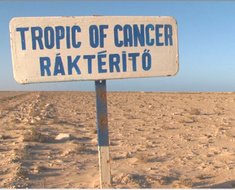
Tropic of Cancer Countries
The Tropic of Cancer is a line of latitude about 23 degrees north of the equator, and is one of the five major lines of latitude, along with the Equator, Arctic and Antarctic circles and Tropic of Capricorn. Can you name the countries whose land mass it passes through?
The Tropic of Cancer is a fluctuating line - only nations that always touch the line are included; countries are listed from west to east
Additional research: buck1017
Rate:
Featured Quiz
Last updated: June 2, 2024
You have not attempted this quiz yet.
More quiz info >>
| First submitted | July 16, 2014 |
| Times taken | 42,387 |
| Average score | 76.5% |
| Rating | 4.93 |
3:00
Enter answer here
0
/ 17 guessed
Time Used
00:00
Best Time
00:00
The quiz is paused. You have remaining.
Scoring
You scored / = %
This beats or equals
% of test takers
also scored 100%
The average score is
Your high score is
Your fastest time is
Keep scrolling down for answers and more stats ...
|
|
|
New and Popular
Save Your Progress

Copyright H Brothers Inc, 2008–2024
Contact Us | Go To Top | View Mobile Site
On a more serious note, by a country JetPunk means a sovereign state. That means that whether the government has control of the country is more important than recognition by other countries. I don't know the exact details of how the sovereignty works in that area of the world, but I'm guessing it's something to do with whether the Western Sahara has an active government that doesn't have to bow to the will of Morocco and enforces its own laws.
However, I don't think there is a consistent criteria for what makes a country in jetpunk. Taiwan, a country recognized by fewer states than Western Sahara, not recognized by the US and a non-member of the UN is counted, and Kosovo, a country recognized by fewer than Palestine and another non-member of the UN is counted while Palestine, a UN observer member like the Vatican and recognized by more than a hundred countries is excluded.
If jetpunk did not care about international recognition and only cared about de facto control, then countries like Palestine, Abkhazia and Somaliland should be counted. If jetpunk followed either US recognition or recognition, why is Taiwan here?
I raised this question multiple times but I don't think it was ever answered
Also 'a mix of international recognition and control of territory' seems like no standard at all and still doesn't explain the exclusion of Palestine and inclusion of Taiwan. Palestine is recognized by more than 70% of UN member states and controls 45% of its claimed land and is excluded, Taiwan controls less than 1% of what it claims (entirety of China, de jure).
According to your logic, Syria does not have control over its territory but is counted as a country. If so, then Western Sahara controlling only 20% of what it claims shouldn't be a problem for you. Regarding recognition, yes Western Sahara is recognized by only 84 UN member states, but that still is more than states recognizing Taiwan.
Look, as long as Taiwan is included and Palestine is excluded, I don't think any standard can explain Jetpunk's recognition of countries.
The most northern point is just on the Tropic and border is just considered as part of a country.
https://en.wikipedia.org/wiki/23rd_parallel_north
Currently it is 23.4° but it is not fixed in time. It oscillates between 22.1 and 24.5 on a 41,000-year cycle. So it has nothing to do with the seasons. See wiki
I was thinking about something in Asia or the Pacific but the Bahamas didn't even cross my mind :D