Featured Quizzes
User Quizzes
Create Quiz
Data and Charts
Badges and Games
About JetPunk
JetPunk Shop
Dark Mode
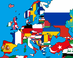
Colour in the Flag Map by Guessing Cities
There are some incomplete flag maps below. To fill them in, guess the largest city within each colour area.
Using citypopulation.de as a source and Wikipedia as a secondary source
Population is by urban area!
Rate:
Featured Quiz
Last updated: August 31, 2020
You have not attempted this quiz yet.
More quiz info >>
| First submitted | April 27, 2020 |
| Times taken | 45,359 |
| Average score | 58.8% |
| Rating | 4.94 |
4:00
Enter city here
0
/ 17 guessed
Time Used
00:00
Best Time
00:00
The quiz is paused. You have remaining.
Scoring
You scored / = %
This beats or equals
% of test takers
also scored 100%
The average score is
Your high score is
Your fastest time is
Keep scrolling down for answers and more stats ...
|
|
|
|
|
|
||||||||||||||||||||||||||||||||||||||||||||||||||||||||||||||||||||||||||||||||||||||||||||
New and Popular
Save Your Progress
Colour in the Flag Map by Guessing Cities
Quiz series by Jiaozira
Copyright H Brothers Inc, 2008–2024
Contact Us | Go To Top | View Mobile Site
It's either inconsistent, or incorrect.
Thanks a lot!
And great work in looking for the most suitable flag/cities combination, I think that maybe there is room for some more countries to be added (like Belgium, Poland, Belarus, Argentina)
I have a couple of suggestions:
1) could you please add in the description that you're using "city proper", I had a hard time thinking of urban areas (e.g.: Naples is bigger than Rome, The Hague is bigger than Amsterdam, etc.)
2) Is it possible to have "Ahrus" as an alternative spelling for Aahrus? I'm always confused, as the Danish name is Åhrus, so there's only one "A".
The map of the Netherlands is not on point though
Thanks
(Sorry if I'm wrong).
It'd be interesting to see a dot on the map once we've found a city.
India was a funny case because in theory the tricolour is perfect for such a regional and highly populated country... and then I had to figure out what to do with the chakra haha.