The 36 Provinces of Canada Map Quiz

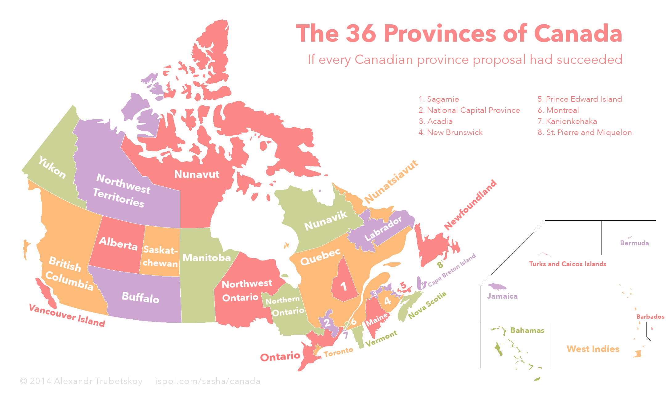
Throughout Canada's history, There have been many proposed provinces and territories. While some have gone through, others have not. If all proposals had succeeded, Canada would have at least 36 provinces and territories. Fill in the map by matching the name of each province or territory.
Based on this map
Quiz by Jiaozira
Rate:
Last updated: August 2, 2017
You have not attempted this quiz yet.
First submittedAugust 2, 2017
Times taken1,895
Average score61.1%
Rating4.75
Report this quizReport
6:00
0
 guessed
36 remaining
The quiz is paused. You have remaining.
Scoring
You scored / = %
This beats or equals % of test takers also scored 100%
The average score is
Your high score is
Your fastest time is
Keep scrolling down for answers and more stats ...
This Province is:
Select Province
Acadia
Alberta
Bahamas
Barbados
Bermuda
British Columbia
Buffalo
Cape Breton Island
Jamaica
Kanienkehaka
Labrador
Maine
Manitoba
Montreal
National Capital
New Brunswick
Newfoundland
Northern Ontario
Northwest Ontario
Northwest Territories
Nova Scotia
Nunatsiavut
Nunavik
Nunavut
Ontario
Prince Edward Island
Quebec
Sagamie
Saskatchewan
St. Pierre and Miquelon
Toronto
Turks and Caicos
Vancouver Island
Vermont
West Indies
Yukon
+8
Level 70
Aug 2, 2017
General notes: most of these proposals are non-existent today, however Northern Ontario, Labrador, Vancouver Island, Bermuda, Turks and Caicos, Nunavik and Nunatsiavut are all serious contenders for new Canadian provinces today. Buffalo was a planned province that was replaced with Alberta and Saskatchewan. Kanienkehaka would have either become a province or an independent country if Quebec succeeded from Canada and would have been for the Mohawk people. Belize would have been a part of a West Indies province, but I could not show it on the map due to limited space. Also, Nunavik and Nunatsiavut are Inuit majority areas that would be territories much like Nunavut. This was a fun quiz to make, I hope you enjoyed it!
+2
Level 76
Aug 2, 2017
This is amazing and so interesting (though Jamaica is just plain weird). A couple of more minutes would help, but I still nominate this one for a star.
+5
Level 70
Aug 2, 2017
Thanks! There was talk of Jamaica joining Canada, but that was long before it's independence, when various North American colonies were joining newly independent Canada. Also, I added two minutes.
+2
Level 56
Oct 5, 2020
Great work! (Also, sorry if you found it annoying that I'm commenting on many of your quizzes :)
+3
Level 70
Oct 5, 2020
Not at all, I quite appreciate your comments! I always make time to reply to comments on my quizzes. Thanks for the kind words, this quiz was a joy to create :D
+2
Level 63
Sep 28, 2021
I know it’s sort of hard to include since all of it’s territory is now part of some other province/territory, but why was the Keewatin District not included?
+4
Level 70
Sep 28, 2021
Keewatin was a territory from 1876-1905, before it was returned to the Northwest Territory. Since it is a former territory and not a proposed territory it isn't eligible to join the quiz. Thanks for asking!
+3
Level 77
Mar 13, 2023
This is super interesting. I wish I could see an explanation for every one that you have added. Also, you could include Red River as a proposed province. I believe that was put forward by the Metis Provisional Government. Yes, it did become Manitoba, but I believe the original proposition was for it to be called Red River. I might be wrong...
+2
Level 70
Mar 13, 2023
If you want a detailed explanation for (most of these), there is a very comprehensive Wikipedia article which explains the history behind some of these. When I first made the quiz, the article was more or less the same as my source map, but the Wikipedia article changed over time.

None of these movements are exactly active today, with the exception of increased Indigenous self-governance. As for Saguenay-Lac-Saint-Jean I believe it was separated due to cultural differences from the southern regions of Quebec.

I believe the Red River represented a colony of Britain, and Manitoba was the propsosed province as a solution to the rebellion (although I slept through some of my Canadian history classes, I could be mistaken).

+2
Level 61
Mar 13, 2023
spotlighted it! :D

Its there in the main page today

+1
Level 70
Mar 13, 2023
Thanks for the support! It's a pleasant surprise to have my quiz on the front page :)
+2
Level 88
Mar 22, 2023
Fascinating map, thanks!
+2
Level 61
Apr 4, 2024
Is that......Jamaica?

Also I'd love to have a quiz where you guess the answers, rather than click them

+1
Level 70
Apr 5, 2024
You exposed the Canadian plan to invade somewhere warm and force them to drink Tim Hortons :)

I agree that fill-in-the-answer is typically better than click quizzes. One reason I haven't done that with this quiz is that many names are difficult to type like Kanienkehaka, and other names like National Capital and Sagamie are merely proposed by the person who made the original map.

+2
Level 61
Apr 7, 2024
True, I'd probably play it religiously because I love quizzes like that

I'd also love more of these "Proposed states" quizzes for different countries (if any more info exists) I would be an avengers level threat if i knew how to make a custom svg.

+1
Level 70
Apr 7, 2024
Another fun idea could be a flag version, where you have to guess the flag of each new 'province'.

There's a Wikipedia page detailing proposed states, provinces and voivodeships in the US, Australia, India, Canada and Poland, it's a very interesting read, although some of the proposals are a little outlandish.

United States

Australia

India

Canada

Poland

+2
Level 79
Apr 13, 2024
This is more on the original map to be honest, but I'm having a bit of trouble finding any sources referring to either Sagamie or Saguenay as a proposed province, serious or unserious. Have you had any better luck?
+1
Level 70
Apr 13, 2024
Honestly, no. Not in French nor English. I know that the region has a distinct culture and regional identity compared to the rest of Quebec but I can't find any reference to succession, and I'm curious where the original map creators got this from.