Featured Quizzes
User Quizzes
Create Quiz
Data and Charts
Badges and Games
About JetPunk
JetPunk Shop
Dark Mode
Vancouver Island Cities on the Map
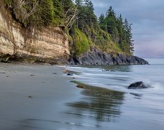
Vancouver Island. Covered in lush temperate rainforests, picturesque seaside towns battered by the tall waves that surfers chase. Home to Cathedral Grove old-growth forest, filming location of the latest Jurassic Park film and Della Falls, one of the tallest waterfalls in Canada. Vancouver Island is one of the most rewarding places in Canada to visit as a tourist, and one of the most desirable places to live (especially around Victoria where the climate is among the most mild in Canada).
There are 36 cities, towns, villages and districts in the region, how many can you name?
Including islands considered to be part of the Vancouver Island region, but excluding the mainland portions of Mount Waddington and Strathcona Regional Districts.
Rate:
Last updated: August 4, 2021
You have not attempted this quiz yet.
More quiz info >>
| First submitted | August 4, 2021 |
| Times taken | 80 |
| Average score | 50.0% | Report this quiz | Report |
5:30
Enter settlement here
0
/ 36 guessed
Time Used
00:00
Best Time
00:00
The quiz is paused. You have remaining.
Scoring
You scored / = %
This beats or equals
% of test takers
also scored 100%
The average score is
Your high score is
Your fastest time is
Keep scrolling down for answers and more stats ...
|
|
|
||||||||||||||||||||||||||||||||||||||||||||||||||||||||||||||||||||||||||||||||||
New and Popular
Save Your Progress
British Columbia Map Quizzes
Quiz series by Jiaozira
Copyright H Brothers Inc, 2008–2024
Contact Us | Go To Top | View Mobile Site
The Spanish were some of the first Europeans to visit the island. Thus, there are several Spanish-language placenames. These names are not pronounced anything like the original Spanish, however (Zeballos is pronounced '/zɛˈbɑːloʊs/' or 'ze-bah-los' for example).