Featured Quizzes
User Quizzes
Create Quiz
Data and Charts
Badges and Games
About JetPunk
JetPunk Shop
Dark Mode
Pixelated World Map
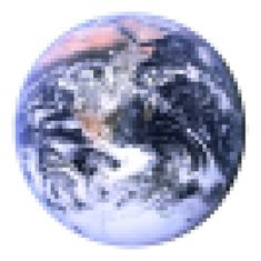
The World has been pixelated! Only pixels with at least 50% land have survived! Each pixel can only be guessed by the country which has the most area inside it!
There are no answer boxes on purpose! The pixel grid is your only resource to name all the countries!
Rate:
Featured Quiz
Last updated: March 21, 2021
You have not attempted this quiz yet.
More quiz info >>
| First submitted | June 25, 2019 |
| Times taken | 109,125 |
| Average score | 92.4% |
| Rating | 5.00 |
7:00
Enter country here
0
/ 1129 guessed
Time Used
00:00
Best Time
00:00
The quiz is paused. You have remaining.
Scoring
You scored / = %
This beats or equals
% of test takers
also scored 100%
The average score is
Your high score is
Your fastest time is
Keep scrolling down for answers and more stats ...
|
New and Popular
Save Your Progress
Pixelated Maps
Quiz series by Stewart
...
Copyright H Brothers Inc, 2008–2024
Contact Us | Go To Top | View Mobile Site
Time constraints always makes me act differently. Instead of just typing all and typing them in order I go quite random all over the map haha, when it takes longer than a split second to name a country in the area I was working on i instantly go somewhere else. So it's like, cambodia, laos...morocco, algeria, egypt... saudia arabia etc.
The time set for this is exactly right in my opinion. No mad dash, but didnt have time to rack my brain over which two I had missed. Which I still might not have thought of with 2 whole more minutes haha. (unless the was an alphabetical list, which indeed I agree should be left out on this quiz)
I suppose that is the point of a pixelated map; if you're looking for accuracy, more traditional maps are the way to go
Scoring
You scored 879/1129 = 78%
This beats or equals 8.3% of test takers
The average score is 1054
Your high score is 879
⬜️⬜️⬜️⬜️⬜️⬛️⬜️⬜️⬜️⬜️⬜️
⬜️⬜️⬜️⬜️⬜️⬛️⬜️⬜️⬜️⬜️⬜️
⬜️⬜️⬜️⬜️⬜️⬛️⬜️⬜️⬜️⬜️⬜️
Just a T
With Africa is where all my other ones were, simply cause didn't have enough time, I swore I wrote Sierra Leone, Gabon and Mozambique, but imagine just typing error.
AMAZING quiz tho
GREAT QUIZ!