Featured Quizzes
User Quizzes
Create Quiz
Data and Charts
Badges and Games
About JetPunk
JetPunk Shop
Dark Mode

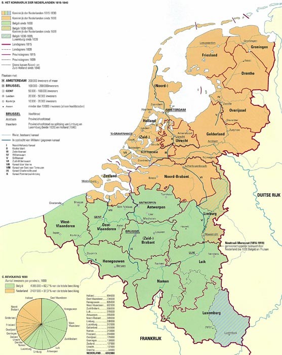
Provinces of the Netherlands in 1816 (with a Map)
Can you name the provinces that made up the United Kingdom of the Netherlands in 1816?
According to this map.
Rate:
Last updated: January 4, 2021
You have not attempted this quiz yet.
More quiz info >>
| First submitted | January 4, 2021 |
| Times taken | 1,758 |
| Average score | 63.2% |
| Rating | 4.69 | Report this quiz | Report |
3:00
Enter answer here
0
/ 19 guessed
Time Used
00:00
Best Time
00:00
The quiz is paused. You have remaining.
Scoring
You scored / = %
This beats or equals
% of test takers
also scored 100%
The average score is
Your high score is
Your fastest time is
Keep scrolling down for answers and more stats ...
| |
|
|
ThatOnePunk
+5
Level 68
Jan 5, 2021
Geweldige quiz! ;)
Dekkie
+3
Level 55
Jan 5, 2021
Dank je wel!
eliasnice
+1
Level 38
Sep 9, 2023
Wait, are you Dutch? I didn't know that!
Jiaozira
+4
Level 70
Jan 26, 2021
I'm a big fan of all your historical regional quizzes as a history major. It's also neat seeing how much territory the Netherlands has conquered from the sea since the 1800s. Thanks for the fun quizzes!
Dekkie
+5
Level 55
Jan 26, 2021
Haha, thanks. You're very welcome.
LuigiDood227
+4
Level 64
Apr 6, 2022
Accept West and East Flanders with just Flanders? It appears Stupid Flanders messes people up a lot.
New and Popular
Save Your Progress
Historical Subdivision Map Quizzes
Quiz series by Dekkie
...
Copyright H Brothers Inc, 2008–2024
Contact Us | Go To Top | View Mobile Site