Exploring Canada's Provinces - #2 Western Canada
Last updated: Saturday December 11th, 2021
Report this blog
Right where we left off...
Last entry I was ranting about Central Canada, comprised of Ontario and Quebec. Originally, I planned to include every province and territory in one blog - but rather predictably I hit the word limit within five provinces.
We pick up where we left off last time, the naturally stunning region of Western Canada. Sit back, grab a delicious Nanaimo Bar and enjoy the ride! Be sure to skip around with the quick links up above, there are four provinces to cover and lots of details to include :)
Western Canada
Close to a third of Canada lives in this land of exceptionally straight borders.
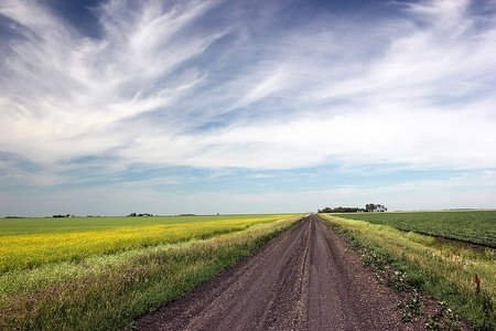
Western Canada is a land where nature is overpowering, be it endless prairies reaching for the horizon, tall mountains towering above valleys of spruce or the roar of the vast Pacific as it smashes against dramatic, rocky coastlines.
In terms of European settlement, Western Canada is sort of a "New Canada", and in much of the region you'd be hard done to find a building built prior to the 20th Century. In addition, all of the fastest growing census metropolitan areas as well as the two provinces who receive the most interprovincial migrants can be found here. Economically the region is known for resource-extraction and tourism.
• Alberta
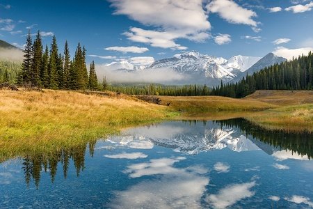
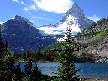
Alberta is the powerhouse of the Prairies, where I will begin this Western Canadian tour. Mountains burst up from the flatlands in the west of the province with little buffer in-between, and this is crucial to Alberta's tourism industry. Banff, Jasper and Waterton Lakes National Parks continue to enchant visitors to this corner of the globe, yet the majority of the province is not mountains, but prairie, forest or badlands.
While the extension of Alberta's arable lands far north into the Peace Country (around 56°N, the northernmost in Canada) has historically supported more people than its eastern two brothers, Alberta's secret lies in the oil and gas industry. The Athabasca Oil Sands ensure that Canada has the fourth largest proven reserves of petroleum after Saudi Arabia and Venezuela, however the sheer importance of oil to Alberta means that the economy is viable to shakeups. Alberta typically attracts the highest number of interprovincial migrants, but during periods of low oil prices these numbers can quickly turn into an exodus (i.e. 2014-15, 2020-21). Fossil fuels extraction's role in Albertan politics makes it one of the most distinctive provinces politically, and this often puts Alberta at odds with other provinces (such as disagreements over the building of pipelines to transport said fossil fuels). This is a controversial topic, and the causes are complex.
Even more controversial is the hockey divide between the Calgary Flames and the Edmonton Oilers, and since 2018 you can even get personalised Flames or Oilers licence plates for your car, dramatically increasing the risk of getting keyed depending which part of the province you visit.
Aside from the most common British Isles-French-Indigenous blend which forms the baseline for Canadian provinces demographically/culturally, Alberta has large amounts of German and Ukrainian heritage, among with other smaller groups. Ukrainians are a large minority on the Canadian Prairies, and Canada has the third largest Ukrainian population in the world after Ukraine and Russia. Some Ukrainian Canadians continue to speak their language after generations, despite the divergence between Canadian Ukrainian culture with that back in Ukraine. Similarly, the German language is kept alive in Alberta, both High and Low German dialects, through the Hutterite and Mennonite populations respectively.
Alberta's Ukrainian heritage greatly affects its love for pierogis (a kind of Central/Eastern European dumpling), while the prime ranchland gives it a major reputation for beef. If you visit, be sure to try the steak. Ranchland culture, such as rodeos, Western wear, line dancing and country music is dominant in the rural areas of the province, and rodeos. Rodeos are quite popular amongst the Indigenous population, a group who makes up a higher percentage of the population in the Prairie Provinces, such as the Tsuut'ina First Nations Festival (Blackfoot). Canadian raising can be strong in Alberta's accent, although this varies from person to person and is not unique to the province by any means.
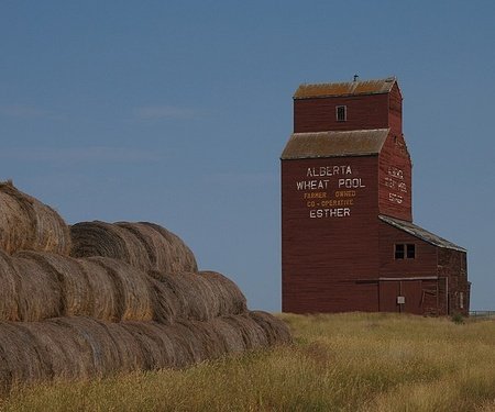
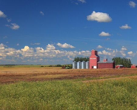
Alberta has a reputation for being the "Texas of Canada", (although this doesn't necessarily mean that Texas is the American state most similar to Alberta, that would have to be Montana). Stereotypes include farmer-type men in cowboy hats and plaid shirts driving pickup trucks. In British Columbia, people joke about the bad drivers who invade the province every summer and don't know how to drive the mountain roads. Alberta is probably the first province mentioned, where the stereotypes are directed towards the rural population, rather than just the biggest city. Grain elevators are a staple of the Albertan countryside, dotting the skylines of small towns, although sadly many have been demolished since their heyday.

Alberta is often split into around six regions, based off of informal cultural and geographical divisions. (Sorry if the quality is a little lower on the map).
Southern Alberta - Hey! This is where I'm from. Southern Alberta is a mostly semi-arid region with farmland, hoodoos and mountains. Different religious groups define the region, such as Dutch Reform (north of Lethbridge), American Mormons (they colonised the southern area of the region) and Hutterites, who live in organised colonies with three different divisions based off of strictness. Hutterites are often compared to the Amish of America, although they don't refuse all modern technology. Cardston is home to an important, historical Mormon temple and that population tends to hold close ties to Utah. Dinosaur fossils and badlands are a staple of the northern region near Drumheller.
Calgary Region - I will talk about this in a moment.
Central Alberta - Moving north, the bare, dry prairie turns into Aspen Parkland in Alberta's most densely populated (non-urban based) region. The Calgary-Edmonton Corridor forms the spine of the region, which including the two largest cities comprises over three million people. Ukrainian Canadians are a larger presence here.
Edmonton Region - I will talk about this in a moment.
Alberta's Rockies - Home to 90% of photos taken in Alberta (not a real fact), plus Banff and Jasper. Most of the region is either a national or provincial park, although it does not contain the southernmost of the Canadian Rockies. Few people live in this tourist-dominated region, and most communities outside of Canmore are strictly resort towns. Kananaskis Country is an often under looked part of the region, holding plenty of 3000-metre-tall mountains, (despite the relatively shorter stature of most Canadian mountains, it should be noted that the overall elevation of the valleys surrounding them is typically lower, meaning that they may have a greater prominence than you might expect).
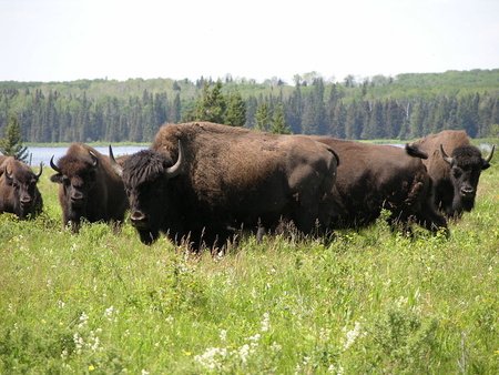
Northern Alberta - This is where loads of that oil I mentioned comes from. Northern Alberta is pushed further north, compared to the other north/south divisions of Canadian provinces mainly due to the receding of the Canadian Shield (which only skims Alberta) as well as the greater reach of agricultural land. Despite this, Northern Alberta contains exceptionally fertile land in the Peace Country, which is shared with British Columbia. The rest of Northern Alberta is defined by Athabasca Country and Wood Buffalo National Park (the largest in Canada home to wood bison). Many Mennonites, especially more conservative denominations, call Northern Alberta home, meaning communities such as La Crête, are primarily German-speaking.
Some important cities include:
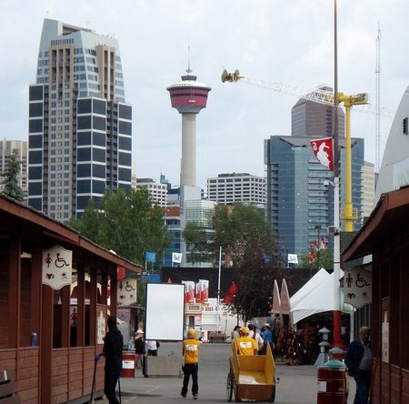
Calgary - If Alberta is the Canadian equivalent of Texas, then Calgary would be our version of Houston. Fueled by oil money, the skyline is expansive and includes such delights as the Calgary Tower (190 m) and The Bow (236 m), named after the Bow River, which weaves throughout the city. In the summer, the famous rodeo/exhibition called the Calgary Stampede comes to town. Although Calgary's sprawl can be a nuisance, this is remedied by its proximity to some of the most beautiful mountains and nature in Alberta. If you love the mountains, yet need to live in a large city, Calgary easily becomes a world class option for you.
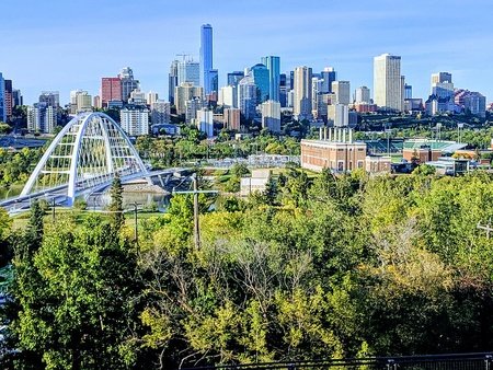
Edmonton - Calgary's more northern cousin, and the capital of the province. Edmonton is Canada's most northerly major city, and therefore it serves as an economic gateway to exploits both in Northern Alberta and even further north into the Territories. Winters infamously plunge to -30°C throughout the winter. Edmonton is known for the West Edmonton Mall, one the world's largest shopping mall, hosting an indoor roller coaster and waterpark, among other attractions.
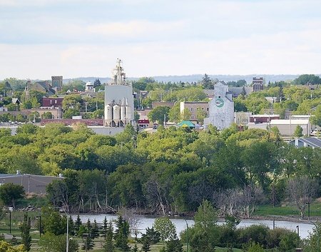
Lethbridge - A regional centre for Southern Alberta, Lethbridge is split in two by the wide Oldman River Valley, and the interesting coulee formations created by erosion. This image is made complete by the largest railway structure in Canada, the Lethbridge Viaduct (known locally as the High Level Bridge), at 95 metres tall (311 feet) and 1.6 kilometres long (1 mile). Warm Chinook winds batter the poor city, especially during the winter, with gusts up to 100 km/h being all too common. On the bright side, Chinook winds can easily raise temperatures up to the 10-20°C during the wintertime, and at least it gives locals something to complain about.
Red Deer - Located midway between Calgary and Edmonton and in the heart of the aspen parkland, Red Deer is around the same size as Lethbridge with a similar focus on agriculture. The Alberta Sports Hall of Fame is located here, after a period of continuously moving between Alberta's largest cities. While the city itself is fairly average, geographically, it is close to a number of large, popular freshwater lakes, such as Sylvan Lake.
Grande Prairie - Once a small, overlooked town, a gas field was discovered here leading to Grande Prairie ballooning to become one of Alberta's largest cities, and the regional centre of the Peace Country. Its economy is fairly diversified today, however, unlike its other northern cousin. This is in large part due to the vast farmlands which surrounds the city in an otherwise forested, depopulated area.
Fort McMurray - Legally an urban service area, this city on the Athabasca River is an oil boomtown just south of the Athabasca Tar Sands. During years where the price of oil is high, the city is full of money and jobs, attracting thousands from other provinces, especially opportunity-poor Newfoundland. So many people come from Newfoundland, that the city is nicknamed "St. John's North", or "the second largest city in Newfoundland". In 2016, a catastrophic fire tore through the city, destroying 2400 buildings and causing the evacuation of 88,000 people.
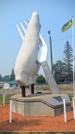
Medicine Hat - A small city on the South Saskatchewan River, Medicine Hat is known for the Medalta Potteries, an old ceramics factory turned museum, and the Saamis Tepee, the worlds tallest tipi made of metal frame. This Southern Albertan city is placed in a gentle valley and its exceptionally sunny climate welcomes many seniors/retirees.
Canmore - Set in the grandiose Bow Valley, this mountain town is overlooked by the signature Three Sisters mountain peak(s). Canmore is magnet for adventure tourism and related sports in Alberta, and the Canmore Nordic Centre, previously a setting for the 1988 Winter Olympic Games, hosts superb skiing and mountain biking trails. Close to Banff National Park, the tourism industry rubs off greatly on Canmore, without completely turning this former mining centre into a resort town.

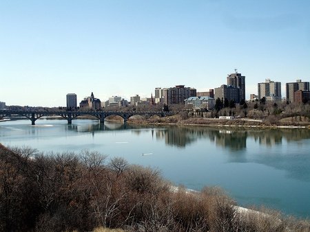
• Saskatchewan
Saskatchewan is notorious for being the easiest Canadian province to spell, and for its tall mountains which frighten even seasoned mountaineers.
Jokes aside, the province is essentially a large, mostly flat landmass with grasslands in the south and the Canadian Shield/vast forests and lakes in the north. In some ways, Saskatchewan resembles Alberta - just on a much smaller scale - and the province has strong oil and gas revenue along with its world class potash and uranium mining. Despite these economic pros, Saskatchewan has struggled to grow its population, with the population growing by around 20-25% from 1930-2021. During the same time period, Alberta has multiplied its population six times.
Much of what I've written about Alberta can be duplicated here, but I'll try my best to highlight unique aspects of the province. For example, Saskatchewan is the only province in Canada, where the predominant ancestry is German. Saskatchewan is one of the Western provinces where block settlements were practised, meaning immigrant groups from specific ethno-cultural backgrounds would occupy specific parcels of land (dispersed in order to prevent widespread ethnic fragmentation). These included the more common immigrants to Canada, people of German, Scandinavian and Ukrainian stock, but also Hungarians (Esterhazy), Jewish people (Edenbridge), English Canadians involved in the temperance movement (Saskatoon) and African-Americans (Maidstone). You can read more here should you wish. There are also bilingual English/French towns, like Gravelbourg and Redvers.
Despite what I've said above, there are still unique phenomenon that give Saskatchewan a sense of regional identity. Once again, sports come in handy, and the province is the stronghold of the Canadian Football League. Canadian football originally derives from rugby, but in its present form is very similar to American football. Saskatchewanians famously defend their only CFL team, the Saskatchewan Roughriders, and their green and white colours are iconic in the province. Saskatchewan is sort of a holdout for the CFL, while the NFL competes for the attention of football-lovers elsewhere in the country. Aside from sports, the word bunnyhug is an unfortunate Saskatchewan word used to refer to a hoodie. If you ever hear someone talking about bunnyhugs, there is a hard chance they are from Saskatchewan. Corner Gas, a sitcom set at a gas station in the fictional town of Dog River, popularised an image of life in rural Saskatchewan and became quite well known across the Prairies.
National stereotypes about Saskatchewan are few, probably due to its lower relevance. However, being from Alberta I know some of our jokes about Saskatchewan too. For starters, jokes about how incredibly flat the province is are abundant, usually in the form of "when a Saskatchewan man's wife leaves him, he can watch her walk off for three days...". Some variations replace "wife" with "dog". Manitoba is flatter than Saskatchewan but the joke still sticks. Other stereotypes are that the people are typically farmer-type hicks/drink and drive. More positive stereotypes are that people from Saskatchewan are incredibly friendly. Albertans also love to complain about the quality of the roads in Saskatchewan.

On to regions. Maybe it is due to a lack of natural divisions, but from all the searching I've done it seems Saskatchewan is best divided into two regions. Some maps reference a "Central Saskatchewan" but I cannot find evidence that Saskatchewanians would use that term. Also, the borders of Northern Saskatchewan seem relatively fluid, sometimes incorporating Prince Albert, even stretching to the North Saskatchewan River, but for the purposes of this blog we'll draw the line at the Northern Saskatchewan Administration District.
Southern Saskatchewan - 97% of Saskatchewan's one million people live here, and this is the Saskatchewan everyone talks about. If anyone ever complains about Saskatchewan being "flat and boring", be sure to show them the rolling, forested Cypress Hills (the tallest point between the Rockies and Quebec), the buttes of Grasslands National Park or the sweeping Qu'Apelle Valley.
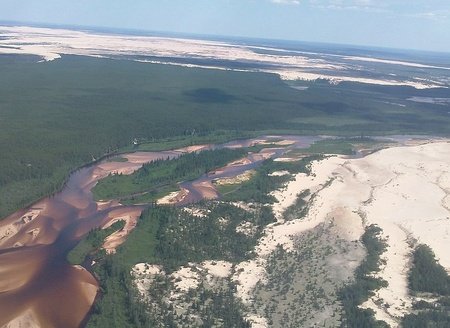
Northern Saskatchewan - Northern Saskatchewan is quite different from the stereotypical image of Saskatchewan, an image of endless farmers' fields. Quite the contrary, the northern half of the province is made up of vast forests and beautiful lakes. Around 86% of the population is Indigenous, especially Cree. Mining is big here, although mining settlements are so remote, that if a mine closes then the town is condemned, such as what happened to Uranium City. What boomed to be one of the largest cities in the region during the 1950s collapsed after the 1980s into a glorified ghost town of 73 people, with no regular road access to the rest of Canada. Across the shores of Athabasca Lake from this settlement lies the impressive Athabasca Sand Dunes, a reminder of the geographical diversity of the province.
Since there are only two regions, I will include double the photos :)
Some important cities include:
Regina - One thing that sets this city apart from some of the other Prairie cities of similar size, is that the land Regina is built on is flat without much in the way of natural features. Only a small creek ran through the townsite, later dammed and turned into Wascana Lake. Although the lake is not directly by the city-centre, some of the most interesting sites in Regina are located along its shores, including the legislation building (Regina is a provincial capital), science and arts centres and lovely parkland.
Saskatoon - Saskatchewan is, like Alberta, dominated by two cities with comparable populations. Nine bridges cross the South Saskatchewan River as it slices through the urban core, giving the city the nickname "Paris of the Prairies". The elegant, Châteauesque Delta Bessborough hotel adorns the skyline and adds much needed character to what could easily be 'just another Prairie city'. Saskatoon is known for its post-secondary institutions, and has a somewhat young, quickly growing population.
Prince Albert - Saskatchewan's "Gateway to the North", as it is the northernmost major centre in the province. Prince Albert is in a transition area between the prairies to the south, and forests to the north, with a very cold climate in winter bordering on subarctic. Prince Albert's best years are behind it, and likely have been since Saskatoon was chosen as the site for the transcontinental railway, although the city continues to reinvent itself and is resilient indeed.
Moose Jaw - About 45 minutes west of Regina, Moose Jaw is much more interesting than just the name. Below the iconic clock tower/city hall, even the streets themselves, lies a vast tunnel network. Today you can take a tour of the tunnels, guided by actors in period dress. These tunnels are known to have had a connection to rum-running and illegal trade of alcohol into the United States during American Prohibition, however unproven myths of Chinese Canadians living in the tunnels and Al Capone himself visiting the site during that era still cloud discussion and excite tourists.
Lloydminster - Created as a British utopian society in 1903, the original settlers who built this town placed it on the line of 110° west longitude. However, just two years later, the provinces of Alberta and Saskatchewan were carved out of the Northwest Territories, divided by the 110° west longitude. This line bisects the city on 50th Avenue, as marked by tall red pillars. Lloydminster is officially a single city, and since Canada is a Federation where different provinces can have different rules and regulation (bad explanation, sorry), this creates a really interesting scenario. Alberta famously has no Provincial Sales Tax, while Saskatchewan does. All of Lloydminister is therefore exempt from the PST to avoid disadvantaging businesses on the Saskatchewan side. Alberta also uses Daylight Savings Time, unlike Saskatchewan, and therefore the entire city practises DST in line with Alberta. Divisions in the city are still seen in other matters, such as telephone numbers and postal codes.

• Manitoba
"Have you been to Manitoba? Do you know anyone from Manitoba? No? Well then, how can you be sure that Manitoba exists?"
Manitoba is a province that takes up a great amount of space, geographically, yet occupies a very small place in the average Canadian's imagination. Manitoba jokes are made even more interesting by the fact that Manitoba is in the centre of Canada, if we are going by width not height, if you are driving across the country you physically cannot avoid Manitoba and the province's capital, Winnipeg, is a fairly large city by Canadian standards.
I can not give you a perfectly sound reason why this presumption exists, but if you held me at goosepoint and demanded an answer, I'd reckon a guess it is exactly because Manitoba is in the middle of the country, making it somewhat isolated from Canada's largest population centres besides maybe Regina and Thunder Bay. Although flying is expensive in Canada, it is generally more convenient than driving, and so this eliminates the need to pass through Manitoba. Even if you do drive, if you are travelling from B.C. or Alberta to Southern Ontario or beyond, it has traditionally been quicker to drive through the United States, avoiding Manitoba altogether (COVID has changed this). Even if you make the drive, Manitoba blends in all too well with the other Prairie Provinces.
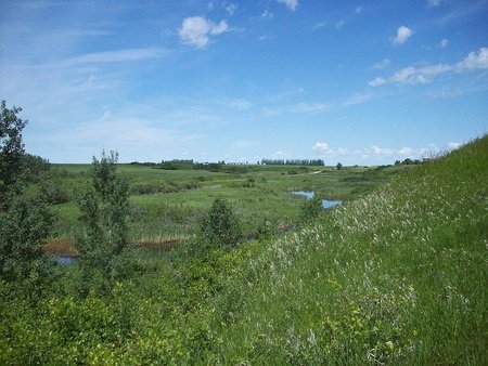
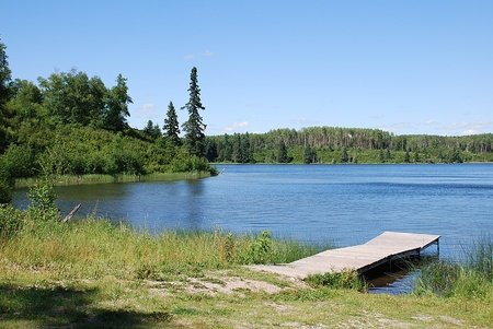
I find this to be a major shame, Manitoba has a lot going on, and is truly fascinating once you become familiar with it. Known as the Land of 100,000 Lakes, and Lake Winnipeg, the 11th largest freshwater lake in the word, along with surrounding lakes define much of the province. These lakes, which are relatively shallow, are an excellent place to visit during the summer (although on a sadder note they contribute to a very large bug population in the warmer months). Manitoba's prairies have higher tree cover than much of the rest of the Prairie Region, as we move away from the arid Palliser's Triangle in Alberta/Saskatchewan, and said prairies become forest much further south
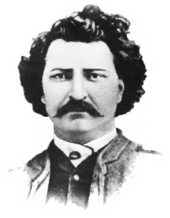
Manitoba is home to some of the earliest European settlements in the West, alongside the fertile banks of the Red River. It is here that the mixed European/Aboriginal Métis culture was born, and if you attended a Canadian public school you will probably remember learning about Louis Riel, who led an armed rebellion and won recognition for Métis identify during a period of threats to Francophone culture and Catholicism in the region (1880s). Métis are often associated with the French language, although other Métis people are descended from mixed Scottish/Aboriginal heritage.
In general, Manitoba has the highest proportion of Indigenous people, compared to any other province in Canada (territories not included). Out of all provinces, Manitoba has the highest percentage of its population crammed into a single city (>50%, the exact number may vary depending on how you measure Winnipeg's population). The province also has a very large Icelandic-Canadian population, along with the other usual European heritage groups found in other parts of the Prairies.
Stereotypes about Manitoba are scarce, other than the joke that they may or may not exist, bar for generic and tired, hick-related images. Like I mentioned, I really don't believe the average Canadian thinks too much about Manitoba.

Unlike Saskatchewan, Manitoba has several regions to talk about!
Winnipeg - I'll cover it in a moment ;)
Eastman - Eastman is prime Red River Country, featuring historic, sometimes Francophone towns (such as Saint-Malo). The land close to the Red River is interesting, in that it is divided into long strips of land - colonial French-style - giving more people access to the riverside. This is contrary to typical English land divisions, which are divided into square acres.
Central Plains Region - Manitoba, and this area in particular, is the centre for Canada's Mennonite population. This religious group, who arrived in Canada from the Russian Empire (and later USSR), are famed for being great farmers, and Mennonite sausages are a specialty of this region.
Westman - Mainly prairies. One area of note is the International Peace Gardens on the American Border. Canadians and Americans can mingle here in these beautiful gardens situated right on the international border.
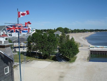
Interlake Region - The holiday region of Manitoba. Some of the provinces best beaches can be found along the southern shores of Lake Winnipeg and Lake Manitoba. Gimli is the centre of the historic "New Iceland" area and just under 30% of the town is of Icelandic heritage. As a tourist centre, they like to celebrate this heritage via flags, re-enactments of Norse battles and a very large Viking statue.
Parkland Region - Arguably home to some of Manitoba's most beautiful sites, Parkland Region contains Riding Mountain National Park (home to a wild bison reserve and a gorgeous lake) and Duck Mountain Provincial Park, where Manitoba's highest point is located. The region has a strong Ukrainian-Canadian heritage.
Northern Manitoba - Sometimes called "Nor-Man" in keeping with some of Manitoba's other regions, this vast, sparsely-populated territory is home to 7.3% of Manitoba, despite occupying well over half of the province's land. Originally part of the Northwest Territories, this mining and tourist-centric region was annexed to Manitoba in 1912, making the province the only one in the Prairies to have a coastline. Speaking of which, Churchill, on the Hudson's Bay, is a historic Hudson's Bay Company Fort turned town where tourists can view some of Manitoba's large polar bear population. No roads lead to Churchill, although Via Rail operates a train route to this remote settlement. Northern Manitoba is largely covered by the Canadian Shield, making settlement here difficult and unnecessary bar resource-towns. A perfect example of the difficulties faced by building on some of this terrain can be seen in the town of Flin Flon, on the Saskatchewan border. In some areas of Flin Flon, sewage/water pipes cannot even be placed underground, and instead are channelled via 'sewage boxes', which also double as sidewalks.
Apologies if some of these descriptions were short, perhaps my own ignorance of Manitoba is showing, too. I will try to give each of the towns a proper spotlight!
Some important cities include:
Winnipeg - The star of the show, Winnipeg (sometimes disparagingly known as Winterpeg) was built at the meeting of the Red and Assiniboine Rivers. This traditionally working class city contains cutting edge monuments, such as the Esplanade Riel Footbridge and the Museum for Human Rights, among older sites including the ruins of Saint Boniface Cathedral and the Exchange District. Winnipeg's reputation as "Canada's murder capital" may strike fear into visitors trying to navigate the city's straight, exceptionally long residential streets, but in reality there are many smaller northern/prairie cities who steal that title. Winnipeg has both large Aboriginal and Filipino communities, at around 10% of the population each (in fact when the Philippines restaurant chain, Jollibee, entered the Canadian market, they chose Winnipeg to open their first establishment).
Brandon - On the lazy Assiniboine river lies Brandon, a city serving 180,000 people in Western Manitoba. Brandon is primarily a trade, rail and transport hub, although the TransCanada Highway only just skims the top of the city.
Portage la Prairie - Called Portage for short, this community was once the centre of Louis Riel's failed, unrecognised state, the 'Republic of Manitobah', founded in 1867. Portage, located between Brandon and Winnipeg, is unique in that it was built around a natural oxbow lake (formed when a meandering portion of a river gets cut off, leading to a distinctive, U-shaped lake). The cityscape, itself curves around the lake, known as Crescent Lake.
Steinbach - Originally founded by Low German-speaking Mennonites from Russia, these Mennonites organised the community into strips alongside the Steinbach Creek, a system known as Strassendorf. This system ended in 1910, although the town continued to speak their dialect of Plautdietsch and several waves of Mennonite refugees from the USSR strengthened the town's numbers. Today, the town still has a strong Mennonite presence, with 22% of the population being native German speakers. This is celebrated by the Mennonite Heritage Living History Museum just outside of town.
Dauphin - This hub for the Parkland Region is also a centre for Canada's Ukrainian population, holding a National Ukrainian Festival and boating beautiful Ukrainian Catholic church buildings which dominate the cityscape, along with the historic railway station. In 2016, only 8.3% of the population spoke Ukrainian as a mother tongue, however.
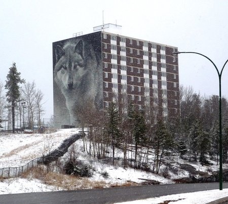
Thompson - Founded in 1956 as a mining town, Thompson now serves as a centre for all of Northern Manitoba, as it has amassed a population of more than 10,000 people. Thompson has been losing people in recent years, however, perhaps due to its brutal climate, remote location and/or high crime rate. Despite this, it is in a great location for outdoor enthusiasts, (or introverts). The Spirit Way mural, painted on the city's tallest building, is a symbol of the community.

• British Columbia
When you visit B.C. for the first time, you will quickly realise just how much of an understatement their licence plate motto "beautiful British Columbia" is! Majestic mountains line both the eastern part of the province but also the western via the Coast Mountains, leaving the middle a large, hilly plateau covered in lavish lakes. Every valley in British Columbia is a different experience, some are brilliant green like the Swiss Alps, others hot, dry and sunny as if they were bordering California.
Unlike the rest of Western Canada, which is considered part of its own region - the Prairies - British Columbia is sometimes categorised all alone, or grouped into the Pacific Northwest (especially when comparing it to the U.S.), although the difference between the B.C. Interior and the Coast is large enough that you could easily break British Columbia into two when talking about it. The differences can be seen, for example, in its economy, which strays from some of the typical agriculture and natural gas industries which dominate the Prairies, leaning further towards forestry, mining, tourism and cinematography (although the former two still exist in corners of the province!)
Once among the most remote of Britain's possessions, British Columbia is today Canada's most culturally/ethnically diverse province. British Columbia is best known for having a high Chinese population, many of whom came from Hong Kong before 1997, although in the present day more Chinese immigration comes from Mainland China. The Chinese community has a long history in B.C., and Chinese labourers where crucial in building the Transcontinental Railway during the 1880's. British Columbia also has a rising Indian population (mostly Punjabi), along with a large Indigenous community and different European communities.
One aspect I associate with a broader "B.C. culture" is an outright embrace of the outdoors. British Columbians are almost always surrounded by natural activities, be it hiking, mountain biking, camping, canoeing, snowboarding, sometimes even surfing! 94% of BC is Crown Land (belonging to the monarch) and is open to public use and wild camping.
Coastal BC has historically been very resource-wealthy, and this gave First Nations people time and capital to create beautiful artwork and elaborate totem poles (another symbol of the region as a whole). Wildlife can be considered a symbol of the province, especially the formidable bears who call the mountains home and may even be spotted in residential areas. In a rare act of compassion with the bears, the British Columbia government has requested that all hikers travel in groups, in order to make sure the bear gets a full course meal when he catches you. A rare subspecies of black bear, completely white and known as the Kermode bear (or spirit bear) is considered the provincial mammal of B.C.
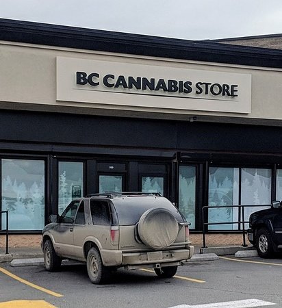
Stereotypes about British Columbia are abundant. I'd say they come in three flavours, on one hand you have either the image of bearded lumberjacks living out in the sticks, and on the other hand you find the much more popular stereotypes of either laid-back stoners or yoga-loving hippies/hipsters. The latter two are often, but not always, intertwined. Although this is very exaggerated, like all stereotypes, somewhat humourously a quarter of British Columbians reported having taken marijuana in the past month (during 2020), the second highest in the country, and the Lululemon brand of yoga gear is one of the largest corperations to come out of the province.
Another popular joke is about the out-of-control housing prices. It is said that any good British Columbian cringes a little inside whenever the Barenaked Ladies song If I Had $1000000 comes on the radio, under the sheer depression of knowing that they could only get a toolshed in someone's backyard for that amount. However, real estate in British Columbia in reasonable in many parts of the province, at least for now.
Unfortunately, nowadays British Columbia is turning into a sort of natural disaster magnet, with bad wildfire seasons becoming all too common. As I'm writing this, a massive flood has taken out vital connections between Vancouver and the rest of the country, and earlier this summer a scorching heat wave killed hundreds of vulnerable people. Hopefully the province will stop making headlines in 2022, it has been a very rough year for B.C.

For British Columbia, I had the opposite problem as I did with Saskatchewan - there are too many regions! If you can to see them all, you can read this list, which I believe to be quite comprehensive. Some listed are minor regions, while others are historical and not terribly relevant anymore. In the end, I had to make grouping based both on my own knowledge but more importantly looking at several maps online. Sorry about any inconsistencies!
Lower Mainland - Normally, only the bottom two Regional Districts on the map are included under this name, comprising 60% of B.C.'s population and a mere fraction of its area. Often times the phrase 'Lower Mainland' is synonymous with 'Fraser Valley', although unlike the former the latter extends across into Washington State. In the Fraser Valley, you can find prime agricultural land on the flat delta of the Fraser River as it snakes from Hope into Metro Vancouver on the coast. Here (around Chilliwack area) you can also find the Bible Belt of British Columbia. Moving north you can find excellent skiing country in Whistler, home of the 2010 Winter Olympics. Even further north is the Sunshine Coast, home to very attractive, yet also expensive communities. Despite being on the mainland, these communities are only accessible by ferry.
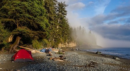
Vancouver Island - Famously home to Canada's most mild climate, making it a very appealing place to move to in a country where people start thinking about winter in August. Much of the south of the island has a Warm-Mediterranean climate, and more temperate palm trees (Chinese windmill palm) have been introduced to the island. Old-growth rainforest can be found on the western half of the island, towards the famous surfing and hippy paradise of Tofino, although most of the hippies have either gone extinct or have been outpriced from the area. Vancouver Island has an interesting sense of identity, perhaps stemming from its former status as a separate colony from the mainland, and when I was there I saw multiple Vancouver Island flags (an imagined version of what a colonial flag for the island might have looked like). I also saw quite a few Japanese (left-hand drive) import cars.
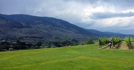
Okanagan - Yet another expensive part of B.C., the Okanagan is centred around a dry and sunny valley home to vineyards and the large Okanagan Lake (where you can find the terrifying Ogopogo lake monster). Osoyoos next to the U.S. border has a claim to being Canada's only desert, but in actuality it isn't technically a desert despite how arid it may be. A lot of Albertan (especially Calgarian) money goes into this region, and it seems like every year the wealthier half of Alberta's senior population ends up retiring to this valley.
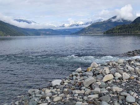
The Kootenays - This well-defined region with slightly less defined borders is one of British Columbia's most beautiful regions. Several mountain ranges, such as the Rockies, the Purcells, the Selkirks and the Monashees tower above a number of valleys, each with its own flavour. The Rocky Mountain Trench, a massive scar stretching down the whole of B.C., bisects this region where it becomes the drier Columbia Valley with Cranbrook and surrounding grassland areas. Meanwhile the Kootenay and Columbia Rivers loop around the region, with the crown jewel that is Kootenay Lake in the centre. In the north Revelstoke and Golden are lovely places to enjoy the heights of British Columbia's many mountains. Certain towns in the south, including Castlegar and Grand Forks, have a large amount of Russian Doukhobor heritage.
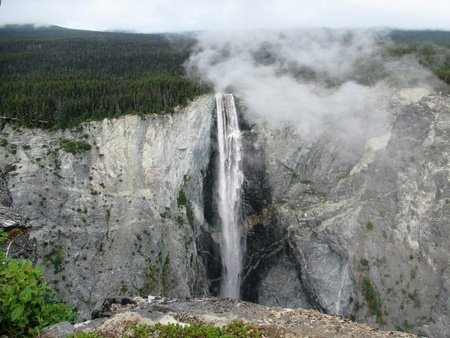
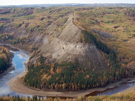
Thompson Country - The rainshadow from the Coastal Mountains leaves the Thompson and Nicola River valleys very dry and arid, however this landscape quickly turns into greenery as you move away from said valleys. Wells Gray Provincial Park houses the massive Helmcken falls, tumbling into a vast gorge, which, at 141 metres tall, are one of the highest in the country when total uninterrupted drop is considered.
Cariboo Country - North of the Fraser Canyon, this vast plateau staged a massive gold rush in the 1860s, which has left behind the famous preserved ghost town of Barkerville. Going north towards Quesnel (pronounced kwi-NEL), grassy areas are replaced by vast forests, and the nearby Bowron Lakes host a spectacular view of this landscape via a canoe circuit. Further west, the road to Bella Coola on the coast was built by volunteers and is incredibly dodgy. This narrow, dirt road is big enough for just one vehicle in areas and lacks a guardrail between you and the ground hundreds of metres below. A true legend for daring motorists.
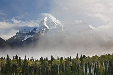
Northern Interior - Mount Robson guards the entrance to this foreboding, yet surprisingly flat region and it is here that the source of the mighty Fraser River can be found. Moving west, mountains reappear in the Alpine, idealic town of Smithers, close to the gate to the Coastal Region. Forestry is a huge industry here. In the Bulkley Valley, there is a culture of ranching and mining. Williston Lake resevoir, near Mackenzie, is the seventh largest resevoir in the world by volume.
Peace Country - Separated from the rest of the province by the Rocky Mountains, you would be mistaken for confusing this region with Alberta. It even has its own oil and gas towns, and the region near Fort St. John consists of Prairies. The beauty of the mountains is never far, however, and Kinuseo Falls near Tumbler Ridge is a highlight. The Alaska Highway begins in Dawson Creek.
Northern Coast - The misty Coast Mountains line the path to the Pacific, an absolutely stunning sight to behold. Just off the coast you can find Haida Gwaii, a unique archipelago home to the Haida people, comprising about half of the modern population, whose ancient longhouse villages once dominated the islands.

Some important cities include:
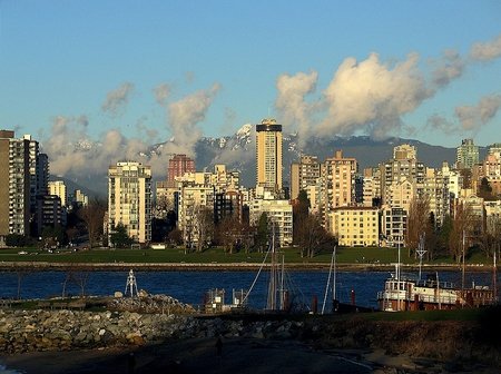
Vancouver - Made distinct by its dense city-centre (by Canadian standards), Vancouver is a place where property values give people headaches. Vancouver proper is quite small, but the greater metro area is a behemoth, spreading out over the entire Fraser Delta (around 2.5 million people) and bordering with the U.S. Gastown is a notorious tourist trap, a pedestrian-friendly street with an interesting mix of old and newer buildings, and a gimmicky 'antique' steam clock built in 1977 to disguise a vent. Vancouver is never far from nature, be it the vast, urban Stanley Park, the infamous 70 metres tall Capilano Suspension bridge or vast mountains and lakes north of town.
Victoria - B.C.'s capital, and perhaps the most temperate place in the country. Victoria is best known for its Victorian colonial architecture, such as Hatley Castle or Craigdarroch Castle. Victoria uses this to create a sort of 'British feel', helping to attract even more tourists. Like Vancouver, only a minority of Victoria lives in the city proper, and the larger urban area population figure balloons by four times. Victoria is a retirement hotspot, having the third highest proportion of seniors (65+) of any city in the country. Victoria is famously for the "newly weds and nearly deads".
Nanaimo - Once a resource-town, Nanaimo, just a short ferry-hop away from Vancouver, has become extensively redeveloped in recent years. The home of the very rich/sweet Nanaimo Bar, this city has become very expensive and desirable, especially for Vancouverites dreaming of owning a detached house. The Old City Quarter is dotted by colourful wooden buildings, leading to the historic harbour area.
Kelowna - Kelowna is the centre of the Okanagan, and the heart of its wine/fruit industries. This sprawling city extends from the lakefront to luxurious estates higher in the mountains, although after so much sprawl there is more incentive to build up rather than out. Kelowna is one of the fastest growing cities in Canada, due to a favourable location/climate, and it also has one of the oldest populations in the country.
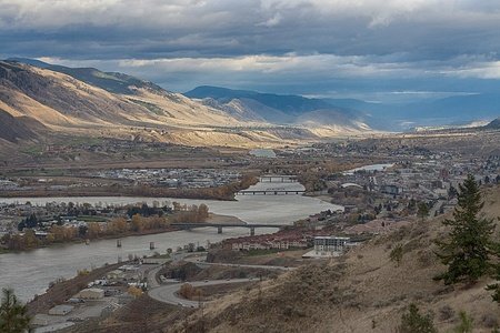
Kamloops - This is where the North/South Thompson Rivers connect, creating an interesting cityscape in the Thompson Valley. Kamloops has a semi-arid, almost desert like climate, which can get very hot in the summertime. The city is notable for having a large amount of golf courses, being quite long/spread-out and also having a constant risk of burning down.
Nelson - The gem of the Kootenays. Nelson has been quite good at preserving its history, and today boasts a preserved, granite city-centre, as well as a functional (albeit gimmicky) vintage tram which runs from the Big Orange Bridge to the Walmart parking lot. Nelson is a very 'artsy' city, originally fueled by large influxes of American draft-dodgers from the Vietnam War. You can find plenty of organic food in Nelson, if that's your thing.
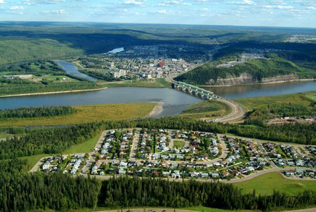
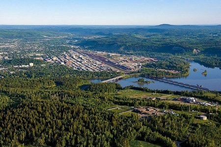
Prince George - Easily the centre of Northern B.C., nicknamed the "Spruce Capital", or PG for short. Prince George is a transportation hub situated on the banks of the Nechako River, where it meets with the Fraser River. The steep cutbanks on the Nechako River are a landmark of the city, and formerly hosted an even called the Sandblast competition, where people could race anything-with-wheels down said banks. It was cancelled after a nasty sofa accident in 2003 sent five people to hospital. Prince George is based on the forestry industry, as the towering Mr. PG icon proudly shows, although the pulp mills in the city leave an unfortunate odour lingering over the lower elevation "Bowl" section of town.
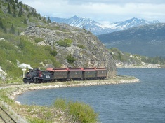
Prince Rupert - While not a hub for the region, like many other cities on this list, Prince Rupert is still a vital port city. It is actually located on an island (Kaien Island), with the actual urban area crammed into the north of said island. This princely city has struggled in recent decades with the decline of its resource-based economy, however heavy industry is promising to reinvent the town, as well as the tourist industry. Prince Rupert is located in an exceptionally beautiful area, with natural splendour and wildlife (including whales) to be seen. Cruise ships often dock here en route to Alaska.

I'm so close to running out of characters, so I am going to have to end this blog pretty quick. Next blog I'll be looking at Atlantic Canada :)
The Discovery Channel even did a segment on the notoious 2003 accident, and looking at the footage it's a minor miracle that no one was seriously hurt.I'm a little amazed that such an event was organised in the first place, but a part of me is also a little sad it had to be cancelled.
Actually, curious about this Sandblast accident. What was exactly?
Asking myself if I’ll be the first to comment on all your blogs (well, you comment first, but...) lolIn Prince George, BC they used to hold a competition called Sandblast, where they raced down the steep cutbanks on skis or bicycles. Then in 2000, someone had the bright idea to add a furniture category to the race. In 2003, three friends attatched bicycle wheels rather than skis to the bottom of a couch, but they veered off course and took out two girls in the audience, before tumbling head-over-heels down the rest of the hill. One girl got a concussion in the process, and they cancelled the games after this. It's such a bizarre story that I had to include it.
Why don’t a connection with Minas Gerais, I made three blogs about it lolAnd yes, although if you remove one of the “a” of Saamis, you receive Samis, that are the people from Lapland lol. And I can’t say Moose Jaw without want to vomit or burp. Salmon Arm? What?
And wow, what a strange and sad story. It looks it was a cool competition until this episode.