Brazilian National Parks - Pictures and Info! #Part 2
Last updated: Sunday April 18th, 2021
Report this blog
- Catimbau National Park
- Cavernas do Peruaçu National Park
- Chapada das Mesas National Park
- Chapada Diamantina National Park
- Chapada dos Guimarães National Park
- Chapada dos Veadeiros National Park
- Descobrimento National Park
- Emas National Park
- Furna Feia National Park
- Grande Sertão Veredas National Park
- Guaricana National Park
- Iguaçu National Park
- Ilha Grande National Park
- Itatiaia National Park
- Jamanxim National Park
- Jaú National Park
You asked for more. You all were very supportive. I’m very grateful for this. I really thought this series would be horrible. You don’t think two times for answer, that I should continue. Thanks a lot! So, I will continue the series! Let's go?
Catimbau National Park
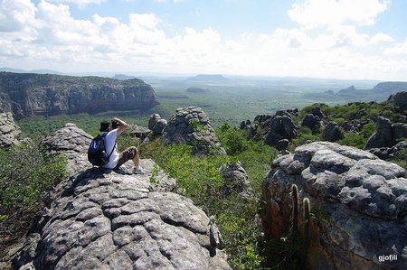
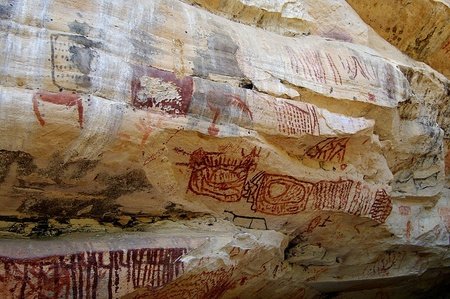
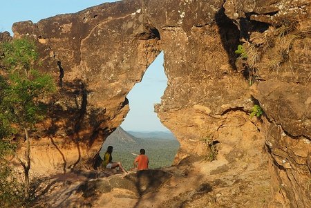
The Catimbau National Park, also known as Catimbau Valley, is a Brazilian national park in the state of Pernambuco. Created on August 22, 2002, it covers the municipalities of Buíque, Ibimirim, Sertânia and Tupanatinga, between Agreste and Sertão Pernambuco. The park is the second in the state (the first is that of Fernando de Noronha). Catimbau preserves one of the last areas of the Caatinga. It is formed by soft top mountains, it is believed that the name Catimbau comes from "hill that has lost its top", however the most accepted version among those who study the etymology of the word "catimbau" is that it comes from the term "catimbó" ", ritual performed by shamans and prayers with indigenous ancestry. The rituals with dances and prayers were performed to cure the most diverse diseases of the physical body and the spirit, so the term "Catimbau" today means "Pray and Cure", more precisely.
Between the mountains are steep slopes and open valleys. It is a region of intense erosion. The geological formations are composed of sandstones of different colors and types that date back more than 100 million years. It has about two thousand caves and 28 cemetery caves. The unit also features records of cave paintings and artifacts from prehistoric occupation dating back at least 6,000 years. There are more than 42 archaeological sites cataloged in the Catimbau Valley. As a result, Catimbau is considered the second largest archaeological park in Brazil, second only to Serra da Capivara National Park, in Piauí. One of the most important archaeological sites is Alcobaça, located on a rocky wall in the shape of an amphitheater. The cave paintings in this locality were made by different ethnic groups from different eras, showing diversity in painting techniques and style. Within the park there are several visit points, including Pedra Furada. It is believed that thousands of years ago the place where Pedra Furada is located was covered by the ocean and that the stone was pierced from the erosion caused by wind and rainwater. Catimbau Valley has elevations with an altitude of 900 meters.
Cavernas do Peruaçu National Park
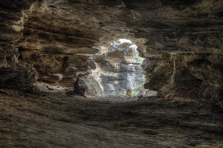
The Cavernas do Peruaçu National Park is a conservation unit created in 1999 whose main objective is to protect this valuable geological and archaeological heritage in this region. With an area of 56 448.32 ha, it is located approximately 45 km from the municipality of Januária and 15 km from Itacarambi, in the northern region of Minas Gerais. With easy access, paved roads and in good condition it is possible to reach your headquarters. It houses more than 140 caves, more than 80 archaeological sites and cave paintings, in addition to the indigenous Xakriabás tribe. It was created in 1999; and it is in the Peruaçu Valley, a region with human evidence that dates back 11 thousand years ago. It is also from this period, the registration of paintings in the local caves and caves.
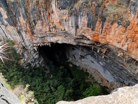
The origin dates back millions of years, even when part of Brazil was submerged by the waters of an inland sea and that with the elevation of the Earth's level made this water dry. This process left entire large limestone massifs that today shelter thousands of caves scattered throughout Brazil. The Peruaçu River, one of the tributaries of the São Francisco River, had its natural course closed by one of these massifs and over time the erosive action of the waters was sculpting the limestone, in search of a way out. The action of time has resulted in a set of caves, many of which are still virgin, which have attracted cavers in search of caves not yet cataloged. Public visitation must be done with great care not to damage the speleothems that took millions of years to form. The park is not open for tourist visits, only for research with authorization from ICMBIO.
Chapada das Mesas National Park
Created in 2005, the Chapada das Mesas National Park is composed of buritizais forests, hinterlands, red plateau relief, composing a set of curious rock formations, canyons, caves and waterfalls. The most outstanding waterfalls are São Romão and Cachoeira da Prata, São Romão has the largest volume of water in the region. These waterfalls are still poorly explored, due to the difficulty of traveling to them, which has to be done with the help of local guides and by trucks with 4x4 traction. Other attractions are trekking to Morro das Figuras (with rock inscriptions) and ecological trails, such as Morro do Chapéu. Pedra Caída is a private complex of 12,000 ha managed by the company PIPES, its interior has a variety of waterfalls. The main one, called a sanctuary, falls from a height of 46 meters.
Chapada Diamantina National Park
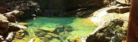
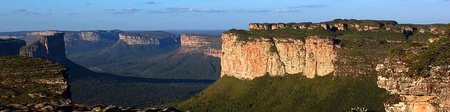
Chapada Diamantina is a region of mountains, protected in the category of national park, located in the center of the Brazilian state of Bahia, where almost all rivers of the Paraguaçu, Jacuípe and Rio de Contas basins are born. These streams of water spring up in the summits and slide across the relief in beautiful streams, plummet into bubbling waterfalls and form transparent natural pools. The national park is managed by the Chico Mendes Institute for Biodiversity Conservation (ICMBio). The highest altitudes of the Northeast Region of Brazil are located in the region: Pico do Barbado, with 2033 meters, Pico do Itobira and Pico das Almas. The geographic formation is part of the set of mountains and plateaus of the East and Southeast of the Brazilian relief and constitutes an extension of the Serra do Espinhaço, therefore, it is a crystalline shield formed in the Precambrian.
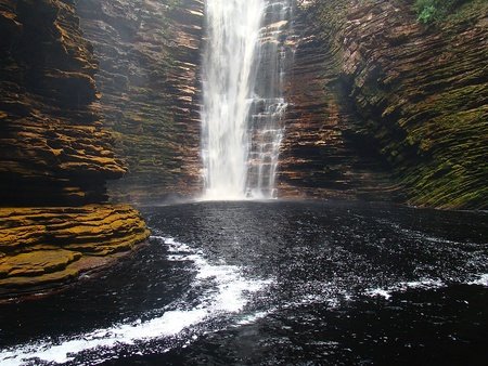
The national park was created on September 16, 1985 by a federal decree, with an area of 152 thousand hectares in the Chapada Diamantina region, distributed by the municipalities of Andaraí, Ibicoara, Iramaia, Itaetê, Lençóis, Mucugê and Palmeiras. It is administered by the Chico Mendes Institute for Biodiversity Conservation (ICMBio). The conscious ecological tourism gives to Chapada Diamantina the best characteristics of a leisure center that preserves nature. Access is via multiple entries without accurate visitation records. Even so, ICMBio claims that Fumaça Waterfall and Aleixos Trail, where there is access control, exceed 25 thousand and 15 thousand annual visitors, respectively. Also noteworthy are the visits to the Pati Trail and towards the Sossego Waterfall. The park is classified as a protected area category II (national park) by the IUCN and aims to preserve natural ecosystems of great ecological relevance and scenic beauty, enabling scientific research, environmental education, outdoor leisure and ecotourism. The main problems with the park's administration are forest fires, land tenure regularization and visitor control, since they endanger the biological diversity, tourist attraction and water supply of Salvador through the Paraguaçu River.
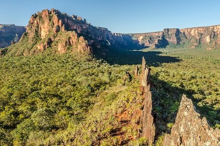
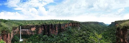
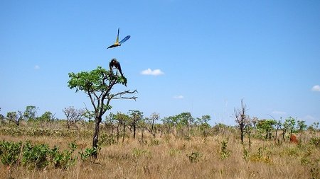
Chapada dos Guimarães National Park
Chapada dos Veadeiros National Park
The Chapada dos Veadeiros National Park is a Brazilian conservation unit with integral protection to nature located in the central-west region of the state of Goiás, in Chapada dos Veadeiros. Until the end of May 2017, the park covered an area of 65 514 ha of cerrado altitude, of which approximately 60% are in Cavalcante and the remaining 40% in Alto Paraíso de Goiás. The park was created through Decree No. 49,875 , issued by the then President of the Republic, Juscelino Kubitschek, on January 11, 1961. In December 2001 the park was included in the list of World Heritage by UNESCO. Currently, its administration is in charge of the Chico Mendes Institute for Biodiversity Conservation (ICMBio).
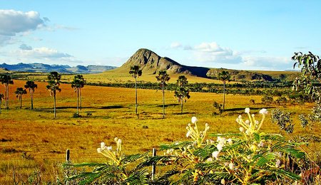
Chapada dos Veadeiros is an important drainage dispersion center, with most of its rivers excavating "V" shaped valleys. The main one is the Preto River, a tributary of the Tocantins River, which forms several waterfalls along its course, with two waterfalls respectively 80 and 120 m high. Among the species of fauna that inhabit the park, about 50 are classified as rare, endemic or at risk of extinction in the area. With regard to flora, 1 476 species of plants have already been identified in the park, out of the 6 429 that exist in the savanna biome. Access to the park is through the São Jorge Village, which is connected to the city of Alto Paraíso de Goiás by a 36 km paved road. Guides to accompany visitors to the park can be found in the village near the entrance to the park, at the Tourist Assistance Center (CAT) in São Jorge. Visiting the park, accompanied by guides, is, however, optional. Among the main attractions of the park are the two jumps of the Preto River, respectively 80 and 120 m high, the canyons of the Preto River, waterfalls in rocky walls of a narrowing of the river, and the Carioquinhas Waterfalls, a formation of natural pools ideal for light baths and whirlpools. In addition to the trails of the park itself, there are several tourist attractions in private lands, around the park. They include:
- Vale da Lua: gray rock formations sculpted by the São Miguel river, which have a "lunar" aspect.
- Almécegas Waterfalls: Two waterfalls, one 50 meters and the other 15 meters, in which water flows down steep rocks. Near the center of Alto Paraíso de Goiás.
- Raizama: set of waterfalls ideal for canyoning and abseiling.
- Thermal waters: natural pools with water at about 38º C of temperature.
- Abismo Waterfall and Mirante da Janela: waterfall overlooking a valley and a viewpoint with rock formation that resembles a window, overlooking Saltos I and II.
Descobrimento National Park
The Descobrimento National Park is one of the Brazilian national parks and together with the Monte Pascoal and Pau Brasil National Park, an ecological corridor of the Atlantic Forest Reserves of the Costa do Descobrimento. It was created on April 20, 1999, close to the celebrations of the 500th anniversary of Brazil, in an attempt to preserve remnants of Atlantic forest in the south of Bahia and still has no infrastructure to be open to visitors. It is administered by the Chico Mendes Institute for Biodiversity Conservation (ICMBio). With 21,213 hectares close to the Cahy River in a humid tropical climate and hot and humid forest, it mainly preserves specimens of redwood, jaguar and harpy (Harpia harpija), which are endangered species. There is also a great historical and cultural wealth that exists on the Descobrimento Coast: place of arrival of the Cabral fleet and vestiges of the ancestors of the Pataxó Indians. It is an integral protection unit, in the municipality of Prado, and has a strong potential for ecotourism. Mostly flat, the park's territory is composed of sandy-clayey soils, with a sandy texture, covered by the Atlantic Rainforest.
Emas National Park
The Emas National Park is a Brazilian conservation unit for integral protection of nature located in the southwest region of the state of Goiás. The park covers an area of 132,000 ha, distributed among the municipalities of Mineiros, Chapadão do Céu, and part of Costa Rica (Mato Grosso do Sul). Created through Decree No. 49,874, issued in 1980 by the then President of the Republic, Juscelino Kubitschek, its limits were later revised by Decree 70,375, of April 6, 1972. The park preserves the various springs of the Jacuba and Formoso rivers, tributaries of the river Paranaíba, from the Paraná River basin. Access to the park can be done through Serranópolis, Chapadão do Céu, or Mineiros. It is currently managed by the Chico Mendes Institute for Biodiversity Conservation (ICMBio).
The UC region is characterized by the Tropical Climate, which includes almost all of the Midwest Region, with a hot climate, ranging from humid to semi-arid, with up to five months of drought. According to the Köppen-Geiger classification, the region fits into the AW type, characteristic of tropical humid climates, with two well-defined seasons: dry, in winter, and humid, in summer. The annual precipitation varies between 1,200 and 3,000 mm, and the duration of the dry period, between 5 and 6 months. The total annual rainfall varies from 2,000 to 3,000 mm in the north of Mato Grosso, decreasing to the West and South, where this value reaches levels around 1,500 mm in the West of Goiás and 1,250 mm in the Pantanal. The hydrographic network of the PNE's area of influence is made up of the Paranaíba River basins, one of the tributaries of the Paraná River, the Araguaia / Tocantins River Basin and the Paraguay River Basin.
Furna Feia National Park
Grande Sertão Veredas National Park
The Grande Sertão Veredas National Park is located on the border of the states of Minas Gerais and Bahia, with headquarters located in the municipality of Chapada Gaúcha (Minas Gerais). It has an area of 231,668 ha. The park's perimeter is 282,341,956 meters. It is administered by the Chico Mendes Institute for Biodiversity Conservation (ICMBio). The name of the park is a tribute to João Guimarães Rosa, one of the greatest writers of Brazilian literature, whose masterpiece was The Devil to Pay in the Backlands (Grande Sertão: Veredas), where he highlights the struggle of the countryside people.
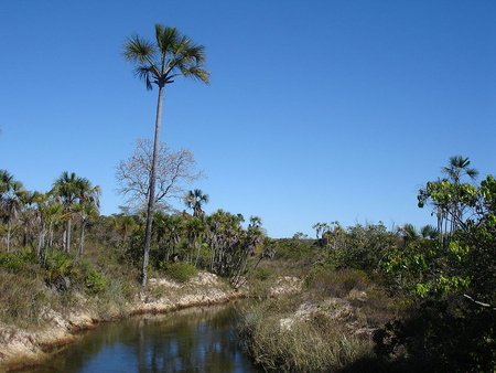
The park preserves part of the plateau called Chapadão Central, which divides the basins of the São Francisco and Tocantins rivers. The vegetation is dominated by the cerrado, making the park the largest in the country with this predominance. There is gallery forest on the banks of the rivers, where many moriche palms can be found. The golden trumpet tree is also common. Among the birds, the presence of greater rheas stands out. The presence of the giant anteater, maned wolf and pampas deer is also noted. That said, hunting, the presence of coal and the constant deforestation characterize the main problems of the park.
Guaricana National Park
The Guaricana National Park is a Brazilian national park located in Paraná, between the municipalities of São José dos Pinhais, Guaratuba, and Morretes. Created in 2014 to protect remnants of the Atlantic Forest in Serra do Mar. It has 49 286.87 hectares and is managed by ICMBio. Even though it is not fully implemented, it already has an intense visitation.
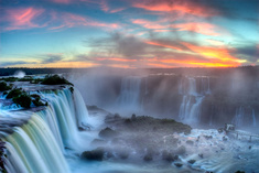
Iguaçu National Park
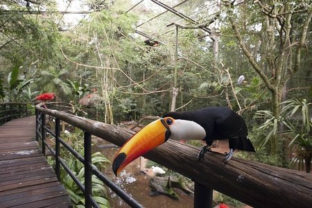
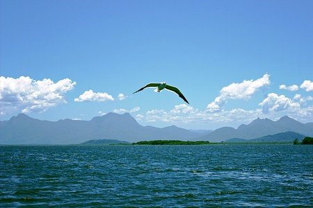
Iguaçu National Park is a Brazilian protected area, belonging to the Conservation Units group. It is located in the extreme west of Paraná, 17 km from the city center of Foz do Iguaçu and only 5 km from the International Airport of Foz do Iguaçu. The National Park has a total area of 169,695.88 hectares, and it contains one of the most spectacular sets of waterfalls on Earth, the Iguaçu Falls. It is administered by the Chico Mendes Institute for Biodiversity Conservation (ICMBio). It is also one of the few conservation sites in the Atlantic Forest, which previously covered more than 1.3 million km² and is now reduced to just 7.3% of that total. Within the Atlantic Forest biome, the park preserves one of the largest stretches of original vegetation in the ecoregion of the Upper Paraná Atlantic Forest, now reduced to less than 5% of its original coverage in Brazil.
As for fauna biodiversity, 257 species of butterflies have now been registered, but it is estimated that there are about 800, mammals have been cataloged 45, amphibians 12, snakes 41, lizards 8, fish 18 and 200 species of birds (IBAMA). According to ICMBio, the Park covers 14 municipalities in Paraná: Capanema, Capitão Leônidas Marques, Santa Lucia, Lindoeste, Santa Tereza do Oeste, Diamante d'Oeste, Céu Azul, Matelândia, Ramilândia, Medianeira, Serranópolis do Iguaçu, São Miguel do Iguaçu, Santa Terezinha de Itaipu and Foz do Iguaçu. On November 17, 1986, it received the distinction, granted by UNESCO, of Natural Heritage of Humanity. Iguazu Falls, along with the Amazon Forest, is one of the 7 natural wonders.
In the year 1542, the Spaniard Alvar Nuñez, appointed Governor of Paraguay, was on his way to the city of Asunción, when he was faced with the grandeur of the Iguazu Falls. He was the first European to know the region, where only the Tupi-Guarani Indians lived at the time. It was in 1876, the engineer André Rebouças made the first proposal to Emperor D. Pedro II on the creation of the National Park. In 1916, Santos Dumont, when he visited the Iguaçu River Falls, was so impressed with its beauty that he pressured the then governor of Paraná, Afonso Camargo, with his prestige, to create a National Park there. The Iguaçu National Park preserves the lush vegetation of the subtropical jungle that surrounds the Falls Area: 2,000 species of plants and 400 of birds. It has two fundamental circuits called Inferior and Superior. In the Lower Circuit, the walkways will lead you to feel the waterfalls from the bottom, while the Upper Circuit will make you feel over the waterfall. Visitors also have a panoramic elevator. You will also be able to fly over Iguazu Falls from Helisul's helicopter, as well as take trips on a motorboat on the river. In addition to the lush waterfalls and their rainbows, you can discover other reasons of interest: the Visitors Center, the Martins Line, the Parque das Aves, the Poço Preto Trail, the Salto do Macuco, the Banana Plant Trail, Rafting, and Santos Dumont Square and Statue.

Ilha Grande National Park
The Ilha Grande National Park is a Brazilian conservation unit with integral protection for nature. Its territory covers the Grande, Peruzzi, Pavão and Bandeirantes Islands, in the Paraná River, divided by the municipalities of Alto Paraíso, Altônia, Guaíra, Icaraíma and São Jorge do Patrocínio, in Paraná, and Eldorado, Itaquiraí, Mundo Novo and Naviraí, in Mato Grosso do Sul. The Ilha Grande National Park was created through the decree without number issued by the Presidency of the Republic on September 30, 1997. Currently, the administration of the park is the responsibility of the Chico Mendes Institute for Biodiversity Conservation (ICMBio).
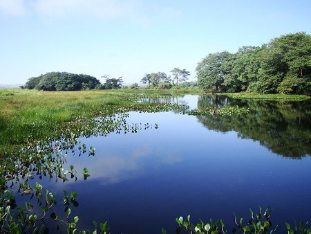
The park, with its 78.875 ha of area, covers all the islands and islets from the Itaipu Reservoir and the mouth of the Piquiri River to the mouth of the Amambai and Ivaí rivers, on the Paraná River, among which the largest are the Grande Islands, Peruzzi, Pavão and Bandeirantes. The area of the park also includes the floodplains and flood plains, located on the banks of the Paraná River, the lake and lagoon waters and their surroundings, and the Paredão das Araras. River waters intended for navigation are not part of the Ilha Grande National Park. The park is open to the public free of charge for visits during all days of the week. The park, in several places, has little beaches, a place of leisure, where you can even swim on the banks of the Paraná River. Another option is the boat ride on the Paraná River, passing through several locations on Ilha Grande.
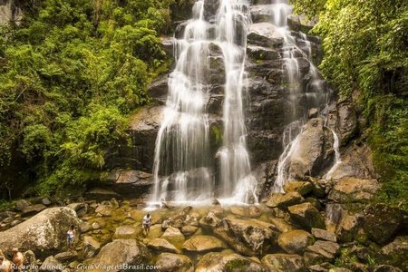
Itatiaia National Park
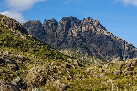
The Itatiaia National Park is a Brazilian conservation unit of integral nature protection located in the Itatiaia massif, in the Serra da Mantiqueira, between the states of Rio de Janeiro and Minas Gerais. Itatiaia is the oldest national park in Brazil, having been created on June 14, 1937, in an area of 11,943 ha, which before being acquired by the Federal Treasury in 1908, belonged to Visconde de Mauá. The name Itatiaia is of Tupi origin and means pointed cliff, pointed stone. Inside the park are some of the highest peaks in Brazil, bordering the 2 800 m altitude. The fauna and flora of the park are quite diverse, mainly due to the difference in altitude of its relief and the varied climate. Itatiaia is currently managed by the Chico Mendes Institute for Biodiversity Conservation (ICMBio). The BR-485, which runs through the park, has its culmination point at an altitude of 2,460 m inland and is thus considered the highest road in Brazil.
The park is located in the Itatiaia massif, in the Mantiqueira Mountains, with territory covering the municipalities of Alagoa, Bocaina de Minas and Itamonte, in Minas Gerais, and Itatiaia and Resende, in Rio de Janeiro. Itatiaia is in an alkaline complex, formed by syenites, foiaites, pulaskites, quartz-syenites, breccias and alkaline granite. Rock formations are considered rare, rarely found in the rest of the country, similar to granite, but in the case of syenite nepheline. Rocks of eruptive origin are also found. In the park, several rivers that form part of the hydrographic basins of the Paraíba do Sul and Rio Grande rivers are born. The hydrographic network is formed by rivers of crystalline waters, which form natural pools and waterfalls. On the plateau, there are several lakes, such as Lagoa Bonita or Lagoa Dourada, among other smaller ones, which can have their surface frozen during severe winters.
On the slope facing the Paraíba Valley, the Atlantic forest predominates with rich and exuberant fauna and flora, herbaceous and has the highest index of endemisms, that is, it is composed of species that only occur there, such as bromeliads and orchids, among others. It is one of only four locations where an endangered tree, the Buchenavia hoehneana, can be found. The fauna of the lower part is richer, providing more shelter for mammals, such as the paca, the coati and some larger species, such as the jaguar, wild pigs and white-lipped peccaries. With a great diversity of birds, such as the hummingbird, as well as green-billed toucans and guachos. The importance of Itatiaia for the conservation of bird species is great in view of the large frugivores and the species inhabiting the upper parts. According to the Köppen-Geiger climate classification, the park is under the influence of three climatic types: Csb (wet temperate climate with dry and temperate summer), Cwb (wet temperate climate with dry winter and temperate summer) and Cwa (wet temperate climate) with dry winter and hot summer). During the Brazilian winter, in the months of July and August, the temperature decreases too much and the rainfall too, leaving the weather dry and very cold. As a result, in a country with 92% of the area located in the tropical zone, phenomena such as frost on the fields and plants in the park can occur, as well as snowfall on the most severe days of the place. In August 2016, the Campo Belo Meteorological Station recorded a minimum of -13.3 ° C, being the second lowest temperature ever recorded in Brazil.
Jamanxim National Park
The Jamanxim National Park is a Brazilian national park located in Pará, next to the municipalities of Altamira and Novo Progresso. It protects forest areas in a region with high deforestation pressure, suffering from unregulated land tenure, land grabbing, deforestation and mining. There are many discussions and controversies about the creation of the national forest in 2006, which was done without previous studies and started to cover areas of livestock occupation that were installed in this region, at the encouragement of the military government with its policy of "integrating not to give up", since the 1960s, creating a conflict of interest between squatters and the Union.
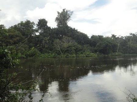
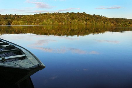
Jaú National Park
The Jaú National Park is a Brazilian conservation unit for integral protection of nature located in the state of Amazonas, with territory distributed by the municipalities of Barcelos and Novo Airão, in the middle of the Amazon rainforest. With an area of 2,367,333 ha, Jaú is the fourth largest forest reserve in Brazil and the third largest park in the world in intact tropical rainforest. Created through Decree No. 85,200, issued by the President of the Republic, João Figueiredo, on September 24, 1980, the park aims to preserve the natural ecosystems included against any alterations that distort them, intended for scientific, cultural, educational and recreational activities.
The Jaú National Park has attractions throughout the year. The periods of drought (usually between September and February) and flood (between March and August) in the Amazon provide different landscapes and experiences. The ideal is to be able to get to know the Amazon in its different cycles. During the dry season it is possible to visit the beaches, rapids, rocks, petroglyphs, while in the flood it is possible to enter the igapó forest and make water trails. The richness of the Tropical Forest (igapós, firm ground, campinaranas, meadowns, plains, moriche palms, among others) rapids, beaches and a large number of records of rock inscriptions and archaeological artifacts are the highlights of the park. The place is represented by a mass of vegetation, being composed by Dense Tropical Forest or Open Forests. On the Rio Negro, next to the Jaú river, the ruins of Airão Velho are located, which was the oldest settlement of Portuguese colonization on the Negro river and was an important trade center during the Rubber Cycle. One of the most extraordinary peculiarities of the Jaú National Park is the fact that this is the only Conservation Unit in Brazil that fully protects the basin of an extensive and voluminous river: that of the Jaú River, of approximately 450 km.
So, we finished the part 2. From Catimbau to Jaú, we saw amazing parks and places. And the part 3? What surprises we will see? Just seeing for discover! Liked? So stay open to the news here on my blog! Thank you very much for that minute of attention, and until the next post!
Crater lake is the best us np. Not biased at allOn a real note, nice blog :)Lençóis Maranhenses
Jericoacoara
Iguaçu
Anavilhanas
Aparados da Serra
Fernando de Noronha
Serra do Cipó
Serra dos Órgãos
Chapada Diamantina
Chapada dos Guimarães
Chapada dos Veadeiros
Brasília
Almost all of them. I can’t say all here, but these that I said looks amazing.