Brazilian National Parks - Pictures and Info! #Part 4
Last updated: Sunday September 12th, 2021
Report this blog
- Pico da Neblina National Park
- Restinga de Jurubatiba National Park
- Rio Novo National Park
- Saint Hilaire/Lange National Park
- São Joaquim National Park
- Sempre-Vivas National Park
- Serra da Bocaina National Park
- Serra da Bodoquena National Park
- Serra da Canastra National Park
- Serra da Capivara National Park
- Serra do Cipó National Park
- Serra das Confusões National Park
- Serra da Cutia National Park
- Serra das Lontras National Park
- Serra da Mocidade National Park
- Serra de Itabaiana National Park
So, part 4, and more 16 parks! I need to advice, that the final part (Part 5) will have just 11 parks, because due to maxium of characters (believe, it got more than 50k when I tried to do both parts together...), and the number of national parks in Brazil (73, prime number...), it didn't work. But let's start one more part!
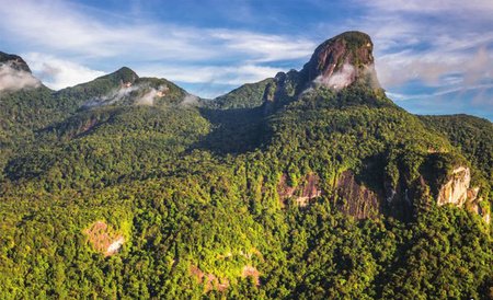
Pico da Neblina National Park
Pico da Neblina National Park is a Brazilian conservation unit for integral protection of nature located in the north of the state of Amazonas, close to the border with Venezuela. In this way, the Pico da Neblina National Park integrates, along with the national parks of Serra do Divisor, Cabo Orange, Tumucumaque Mountains and Monte Roraima, the set of National Parks bordering the Brazilian Amazon. Its territory is distributed among the municipalities of Santa Isabel do Rio Negro and São Gabriel da Cachoeira.
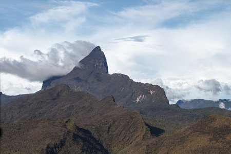
The Pico da Neblina National Park was created on World Environment Day, on June 5, 1979, by President João Figueiredo. The park houses the peaks of Neblina and 31 de Março, which, respectively with 2 993.78 and 2 972 m of altitude, are the two highest mountains in Brazil. With an area of 2,252,414.68 ha, equivalent to 22,524.15 km², its administration is currently under the Chico Mendes Institute for Biodiversity Conservation (ICMBio). The park was created in 1979, with the objective of preserving the untouched natural wealth of the region, in addition to protecting a representative sample of the Amazon ecosystem. The park is next to the Serranía de la Neblina National Park, in Venezuela, to the north. To the south, it is bounded by the Negro River. The park is in the geological province of Western Amazon and is on the northwest limit of the Guiana Shield. Crystalline rock formations of the Guianas plateau predominate, but there are also sedimentary rocks from the Roraima group. The land covers parts of the Roraima sedimentary plateau, the Amazonas-Orinoco plateau and the Rio Branco-Rio Negro pediplane. The average annual rainfall is 3,500 to 4,000 mm, with no pronounced wet or dry seasons. The average temperature is 26 ° C and varies from 9 to 40 ° C. At the highest points, temperatures can drop to 0 ° C.
It has a wide variety of plant formations with different endemic and rare plants. The first botanists who visited the park consider it to be one of the places with the greatest biodiversity and endemism on the planet, but detailed studies are lacking to confirm this. Vegetation types include campinarana and dense forest. Much of the park is also part of an indigenous territory. The north and east of the park cover part of the Yanomami Indigenous Land, which includes about 50% of the park. The park overlaps with the Rio Negro II Middle Indigenous Territory in the south. The west of the park contains 93.73% of the 257,000 hectares of the Balaio Indigenous Land, approved in 2009. The northwest overlaps the Cué-cué / Marabitanas Indigenous Land. There are 46 communities in the indigenous territories, including members of the ethnic groups yanomami, toucans, tuiúcas, desanos, baníuas, coripacos, carapanã, barés, tarianas, piratapuias, yepamasãs, cubeos and warekenas.
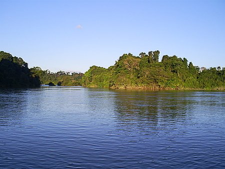
Restinga de Jurubatiba National Park
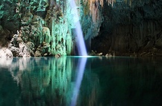
The Restinga da Jurubatiba National Park is the first National Park in Brazil to exclusively understand the restinga ecosystem, the least represented in the National System of Nature Conservation Units. Most researchers agree that Jurubatiba is the best preserved sandbank area in the country and is practically intact. It is located in the northern region of the state of Rio de Janeiro, in Brazil, covering the fluvial and marine plains of the coast of the municipalities of Quissamã, Carapebus and Macaé.
It comprises a strip of waterfront with an area of 14,860 ha and 44 km long along the beach, about 2 km wide at the west end, next to the Cabiúnas lagoon and 4.8 km wide at the east end (channel Ubatuba), with a perimeter of 123 km. Of the total area, 62.38% is in the municipality of Quissamã. It is administered by the Chico Mendes Institute for Biodiversity Conservation (ICMBio). "Jurubatiba" is a term of Tupi origin, meaning "gathering of jeribás", through the junction of jeri'wa (jeribá) and tyba (gathering). This sandbank, the largest in the country, was formed from the retreat of the sea during the Quaternary period. The successive juxtaposition of sandy deposits parallel to the coast created dunes between three and eight meters high, up to ten meters wide, giving rise to the sandy plain and at least eighteen lagoons. The soils are basically of the regossolo type, and saline and organic soils are also found. Summer is hot and rainy and winter is drier. The annual average temperature varies between 22 and 24 degrees centigrade and the annual precipitation between 1,000 and 1,350 millimeters. The lagoons have, in general, the elongated shape when more distant from the coast, which becomes rounded when the lagoons encounter dunes that dam their access to the sea. It is often the case that a very narrow lagoon or the elongated part of it is improperly called "river" by the inhabitants of the region. The Park includes vegetation formations that vary from the beach (creeping formation), through sparse shrubs, areas permanently or periodically flooded, to the high forests in the most distant places from the sea.
The lagoons have, in general, the elongated shape when more distant from the coast, which becomes rounded when the lagoons encounter dunes that dam their access to the sea. It is often the case that a very narrow lagoon or the elongated part of it is improperly called a river by the inhabitants of the region. The Park includes vegetation formations that vary from the beach (creeping formation), through sparse shrubs, areas permanently or periodically flooded, to the high forests in the most distant places from the sea. The Black Lagoon of Jurubatiba is one of the only places in the world where the micro-crustacean Diaptomus azureus is found, which according to UFRJ researchers, only has similar ones on the west coast of Africa, proving, therefore, that this continent has already been united with the coast of Brazil in remote times.
Rio Novo National Park
The Rio Novo National Park is a Brazilian national park located in Pará, close to the municipalities of Itaituba, Jacareanga, and Novo Progresso. It was created in 2006, and has 538 151.33 hectares. Like many parks in the Amazon region, it suffers from unregulated land tenure and illegal deforestation and mining. Still, much of the park is still covered with native vegetation.
Saint Hilaire/Lange National Park
The Saint-Hilaire / Lange National Park is located on the coast of the state of Paraná and covers the municipalities of Matinhos, Guaratuba, Morretes and Paranaguá. It occupies a stretch of Serra do Mar, known as Serra da Prata and has an area of 25 119.14 ha. It was created on May 23, 2001, by Federal Law 10.227, having been the first Brazilian National Park created by initiative of the National Congress. Its name is a tribute to the French naturalist Auguste de Saint-Hilaire and the biologist and environmentalist from Paraná, Roberto Ribas Lange. The Park's objective is to protect and conserve Atlantic Forest ecosystems existing in the area and to ensure the environmental stability of the resorts under its influence, as well as the quality of life of coastal populations. It is administered by the Chico Mendes Institute for Biodiversity Conservation (ICMBio).
The vegetation is represented by the Atlantic Forest, in its different physiognomies: Submontane Ombrophilous Forest, Montana Dense Ombrophilous Forest and Altomontana Ombrophilous Forest, in addition to the Vegetation Refuges (Campos de Altitude) and secondary vegetation found mainly in low-altitude regions where changes promoted by human activities were more frequent. Several endangered species are found at national and state level. It has a typical fauna of the Atlantic Forest of the Serra do Mar of southern Brazil, composed mainly of small and medium-sized species, adapted to the closed environment of the forest. Several endangered species are found, such as ocelot, jaguar, puma, jacutinga, purple-headed parrot, maria catarinense, maria-da-restinga and others that are in danger both at national and state level. This National Park has an Advisory Council, created in 2008 and formed by representatives of the four municipalities covered by the Unit, in addition to non-governmental organizations and state and federal government agencies operating in the region. The Park Management Plan is being prepared.
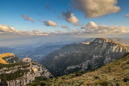
São Joaquim National Park
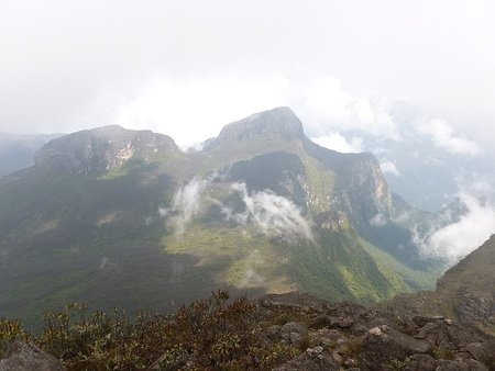
The São Joaquim National Park is a Brazilian conservation unit for integral protection of nature, located in the mountainous and southern regions of the state of Santa Catarina, with territory distributed by the municipalities of Bom Jardim da Serra, Grão-Pará, Lauro Müller, Orleans and Urubici. Created on July 6, 1961 by decree No. 50,922, the park's administration is currently in charge of the Chico Mendes Institute for Biodiversity Conservation (ICMBio).
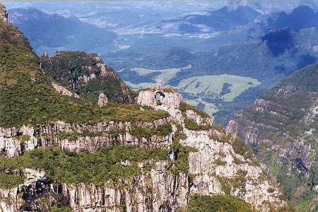
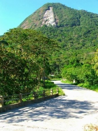
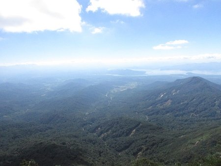
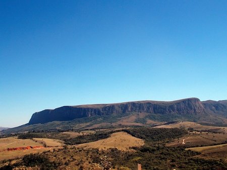
The park has 49 300 ha and is connected in the western portion to the Serra Furada state park. Together, both parks add up to 50 630 ha of protected area. The park is based on sandstone, resulting from the division of continents and Basalt, volcanic rocks dating from the Hauterivian period, approximately 133 million years old. The springs of the rivers that form the Canoas, Tubarão and Pelotas basins are located inside the park. In addition, there are important loading and unloading areas for the Guarani Aquifer. Of very irregular relief, with altitudes varying between 300 and 1,822 m, São Joaquim embraces from countryside landscapes to large furnas and slopes covered with native forest, with canyons. The highest altitudes are in the northeast of the park, with the summit at Morro da Igreja, measuring 1,822 m. The Campos de Santa Bárbara are located in the central part of the park and have altitudes of up to 1,650 m. The soil is predominantly stony. The park is inserted in the Atlantic Forest biome and, due to its wide scope, there are four types of plant formations: dense rain forest, mixed rain forest, altitude fields and cloud forests. Two species of birds are endemic to the park. The most well-known attractions of the São Joaquim national park are its summit and a rocky crevice, called Janela Furada or Pedra Furada, located in Morro da Igreja. The Furada Window is often confused with the Serra Furada, a sandstone crevice approximately 45 m high and 8 m wide, located a few kilometers away in the neighboring Serra Furada State Park. Another attraction of the park is the Canyon of Laranjeiras. The park is open to public visitation and there are no fees. Accompaniment by accredited guides is required to make trails within the Unit. Despite the park's name referring to the municipality of São Joaquim, access to the main attractions is from the municipalities of Bom Jardim da Serra and Urubici.
Sempre-Vivas National Park
The Sempre-Vivas National Park is located in Serra do Espinhaço at the watershed of the São Francisco and Jequitinhonha River basins, in northern Minas Gerais, Brazil, approximately 300 kilometers from Belo Horizonte. It covers four municipalities: Olhos-d'Água, Diamantina, Buenópolis and Bocaiúva. It was created through decree no. Of December 13, 2002 with the aim of ensuring the preservation of natural resources and biological diversity, as well as providing scientific research and the development of educational, recreational and eco tourism activities.
It has an area of 124,555 ha. It is administered by ICMBio. The conservation unit is located in a region of high historical and cultural importance, which led UNESCO to declare the municipality of Diamantina, a World Heritage Site. The name of the Park is a reference to the various species of “evergreens (sempre-vivas)”, small flowers typical of the region where it is located. Tourism is only allowed after authorization from its protection agencies. Access to the park is via the Inhaí district, which is 50 km from Diamantina. The site is home to a large concentration of springs from the tributaries of the Jequitinhonha River, with beautiful waterfalls. The physical landscape of the region is marked by extremely heterogeneous characteristics. The region has a semi-humid tropical climate with an average annual temperature of 20ºC and an average annual rainfall ranging from 1250 to 1500 mm. The Sempre-Vivas National Park has a great environmental heterogeneity, forming a complex mosaic of plant types, still in an excellent state of conservation. They have been recorded in the region of this dense forest from the bottom of the valley to the typical rupestrian fields of high altitudes. According to studies carried out in the Serra do Espinhaço region, about 70% of the evergreens, a group of euriocauláceas, in the world are concentrated in this mountain range. Serra do Espinhaço is also a region of great biological relevance. It was considered by the World Wildlife Fund (WWF) and the International Union for the Conservation of Nature (IUCN) as one of the centers of plant diversity in Brazil due to the high degree of endemism. The high degree of preservation of the region is even more evident with the presence of animal species threatened with extinction such as the jaguar and the puma, species that due to their high size and feeding habits need well-preserved areas with many food resources to survive. Among the birds, there is the presence of the red-and-green macaw and the blue-and-yellow macaw. There is also the presence of the ocelot, maned wolf, giant anteater, giant armadillo, catitu, otter, Pampas deer, among others.
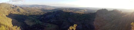
Serra da Bocaina National Park
The Serra da Bocaina National Park is located on the border between the states of Rio de Janeiro and São Paulo, in the southeastern region of Brazil. It is a segment of Serra do Mar. The Serra da Bocaina National Park was created by Federal Decree in 1971, comprising an area of approximately 134 thousand hectares and an expressive biodiversity.
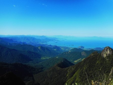
The creation of the park had the objective of implanting a shield of native vegetation, in the escarpments of Serra do Mar as protection of an eventual nuclear accident in the plants of Angra I and II. The headquarters of the park is in the city of São José do Barreiro, in the State of São Paulo. It is administered by the Chico Mendes Institute for Biodiversity Conservation (ICMBio). Among the fauna of the park are the jaguar, cougar, maned-sloth, buffy-tufted marmoset, and countless species of birds. The park offers a wide range of natural tourist attractions, such as Santo Isidro Waterfall, Posses Waterfall and more inside the park, Veados Waterfall. The entrance to the park also marks the beginning of the final stretch of the Gold Trail, with a length of approximately 73 kilometers, and ending at Mambucaba Beach, in Angra dos Reis. Its highest point is Pico do Tira o Chapéu, which reaches 2,088 meters above sea level, one of the highest points in the State of São Paulo.
Of the 156 species of non-flying mammals with distribution to the Atlantic Forest listed in 1996, there are 40 species in the park, 25% of which are threatened with extinction. The southern-muriqui, considered the largest primate in America, is still sought after by hunters in the areas around the Park and is very sensitive to changes in habitat. The forests located across the altitudinal gradient of the Serra da Bocaina favor the concentration of the vast majority of mammal species, such as the otter, the collared peccary, the white lipped peccary, the tapir, the felines such as the ocelot and puma, and canids such as the bush dog and maned wolf.
Serra da Bodoquena National Park
The Serra da Bodoquena National Park, created in November 2000, with 76,400 ha, is managed by the Chico Mendes Institute for Biodiversity Conservation (ICMBio). Bodoquena Mountain Range, located on the southwestern edge of the Pantanal Complex, in the state of Mato Grosso do Sul, is one of the most interesting ecosystems in the Pantanal. It is formed by the cities of Porto Murtinho, Bonito, Jardim, Miranda and Bodoquena.
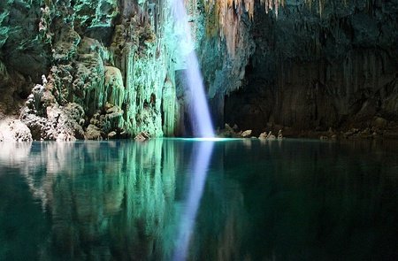
Protected species include the ancistrus, the jaguar and the puma (Puma concolor). The park belongs to the cerrado biome. It covers an area of 77,022 hectares, was created on September 21, 2000 and is managed by the Chico Mendes Institute for Biodiversity Conservation. Serra da Bodoquena is located in the Pantanal Biosphere Reserve, which also includes the national parks of the Pantanal, Chapada dos Guimarães and Emas, in addition to the state parks of the Serra de Santa Bárbara, Rio Taquari Springs and the Rio Negro Pantanal. Modern and ancient limestone tufts, the latter located in abandoned drainage channels, have excellent leaf molds, which, together with studies of carbon and oxygen isotopes, enable paleoclimatic and paleo-hydrological interpretations. In addition to this scientific interest, the limestone tufts form landscaped sets of unusual beauty, much sought after by tourists, reasons that imply the need to preserve these deposits and pay special attention to the quality of the water in their rivers, on which the continuity of the formation of these deposits. The rivers of the region are known for their very crystalline and bicarbonated waters, of brackish taste. Such transparency is due to the following factors: the source of the spring with very little turbidity, not acquiring clay in its movement, in the springs very pure limestone rocks avoid the presence of clay. This limestone present in the rivers that comes from such rocks present in the springs acts as a filter, depositing the impurities at the bottom, where rocks are in permanent dissolution and through fractures in the soil form caves, chasms and underground channels.
The tropical climate, with an average temperature ranging from 25 to 30 ° C in summer, from 15 to 20 ° C in winter, reaching 0 to 40 ° C. Summer is rainy, and dry winter are the two seasons present in the Planalto da Bodoquena. The average rainfall ranges from 1200 to 1500 mm per year and the dry period lasts 3 to 4 months with brief droughts from May to August.
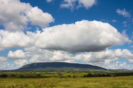
Serra da Canastra National Park
The Serra da Canastra National Park is one of the most important Brazilian national parks, created in 1972 through decree 70.355 of 1972. Within the park is located the historical source of the São Francisco River, in the municipality of São Roque de Minas. Provided with an initial area of 200 thousand hectares, the National Park only took place in an area of 71,525 ha and this until today is the cause of a lot of conflict in the region, due to the intention of IBAMA to expropriate the rest of the area originally planned.
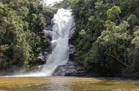
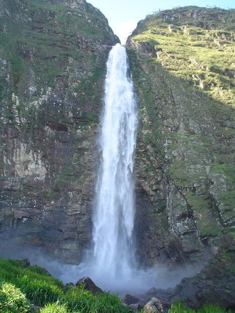
Serra da Canastra is between the municipalities of Capitólio, Delfinópolis, Sacramento, São João Batista do Glória, São Roque de Minas, and Vargem Bonita. It has the shape of a chest, hence the origin of the name, as canastra is a type of ancient chest. The Casca d'Anta waterfall, approximately 186 meters high, is one of the main attractions of the Park, coming out of a natural cut of the Serra of approximately 144 meters, that is, the height of the Serra reaches 330 meters. The São Francisco River rises 14 kilometers before its main fall. The Park protects a scenery of rare beauty, its transition vegetation between the "edge of the Atlantic Rainforest" and the "beginning of the Cerrado (Savanna)", with predominance of Campos de Altitude that shelter countless species of fauna and flora of the cerrado, such as the maned wolf, the giant anteater, the pampas deer, several hawks and endangered species such as the Brazilian merganser and the Giant armadillo. Water is the predominant factor in the park, whose springs, which number in the hundreds, arise due to the humidity that cold rock absorbs from the air, especially at night. The São Francisco River has its historical spring in the Serra da Canastra, more precisely in the municipality of São Roque de Minas and its first great waterfall, the Casca d'Anta, with 186 meters of height, is in the district of São José do Barreiro (MG), and it is accessed through ordinance 4 of the National Park, located in this district. In the park, is produced the famous Canastra Cheese, considered Brazilian intangible cultural heritage. Canastra Cheese, is made with raw cow's milk, and has a sharp, dense, and slightly spicy taste. It harmonizes with wines. There are many places for visit, like:
- Vale da Babilônia (Babylon Valley): Vale da Babilônia is a valley (as its name says) in the heart of the Serra da Canastra. From it, there are many viewpoints, which provide beautiful views of the mountains. The name is due to the stone walls, associated with the Walls of Babylon.
- Historical Spring of the São Francisco River: That's right! One of the main rivers in Brazil, and Latin America has its source in the Serra da Canastra, in the municipality of São Roque de Minas. The name "historic" is due to the fact that it was believed that the source of Velho Chico (popular name given to São Francisco) was at that point. Currently, the geographic source is 50km up, in the municipality of Medeiros. The spring was discovered shortly after the arrival of the Portuguese in Brazil. The expedition that passed through São Francisco was commanded by the famous Américo Vespúcio. In 2014, during a long drought, the spring dried up completely. Fortunately, almost 3 months later, with the return of the rainy season, the water started to sprout again.
- Casca d'Anta: Serra da Canastra is one of the places with the highest number of waterfalls in Brazil. Neither place worldwide they are in so many shapes and sizes. The Casca d'Anta, is the best known of them. It is the largest waterfall in the course of the São Francisco River, with 186 meters high, the equivalent of a building with more than 50 floors. The name of the waterfall comes from a native tree of the same name, with medicinal properties. Tapirs rub against it to heal wounds.
- Maria Concebida Complex: Another waterfall in the Serra, the Maria Concebida Complex is a group of jumps that form emerald-green crystalline wells. It is known as Caribe Mineiro (Minas Gerais Caribbean)
- Furnas HPP: The Furnas HPP is hydroelectric plant located in Rio Grande (Grande River/Great River), between the municipalities of São José da Barra and São João Batista do Glória, in the state of Minas Gerais. It has eight generating units with an installed total of 1,216 megawatts. At the time of its construction, which started in 1958, it became the largest work in Latin America in execution, for which the state company Furnas Centrais Elétricas was created for its management. The reservoir formed by the plant, known as Furnas lake, or popularly "Mar de Minas (Minas Sea)", currently baths 34 municipalities in Minas Gerais. It covers about 1 440 km², when at the maximum level of operation, south of Minas Gerais. The lake extends over two main arms, the first to the east of the dam, following the course of the Rio Grande, for 240 kilometers and the other, to the south, following the course of the Sapucaí River, extending for 170 kilometers. It has many branches, and its perimeter is about 3,500 kilometers.
- Capitólio: Capitólio is a Brazilian municipality in the state of Minas Gerais. According to the Brazilian Institute of Geography and Statistics (IBGE), its population was estimated at 8 663 inhabitants in 2020. Capitólio has become an important tourist destination in Minas Gerais, much sought after in recent years due to its beautiful waterfalls and rivers. transparent waters. The Furnas Canyon is the main attraction, with its stone walls invaded by the green waters of the Furnas Lake, formed by the own Furnas Hydroelectric Power Plant.
- Rio Grande (Grande River/Great River): Rio Grande is a watercourse that bathes the states of Minas Gerais and São Paulo. The river runs 1360km, making the border between Minas Gerais and São Paulo. By merging with the Paranaíba River, in São Paulo, they form the great and flowing Paraná River.
- Rolinho Waterfall: The Rolinho Waterfall is over 200 meters high. The crystalline waters at the foot of the attraction, are one of the preferred habitats of the highly threatened Brazilian Merganser. It is estimated that its population is 200 to 250 specimens, and the largest group, with 100 of them, is located in the park.
- Fundão Waterfall: The Fundão Waterfall is one of the most beautiful and exotic waterfall in the Serra da Canastra, its odd beauty is intact due to the difficulty of access, one of the main reasons for its preservation, having a small number of visitors collaborating with the reduction of the environmental impact around the same. Formed by the crystalline waters of the Santo Antônio River, which plummet strongly and can form waves in the well. The place receives sun almost all day. The difficulty of access is one of the reasons that make Fundão, a place that is still well preserved.
- Vento Waterfall (Wind Waterfall): The name refers to the spectacle provided by the waterfall: delicate due to the small volume of water and high (about 150 meters), it is moved by the wind, changing shape all the time. In addition, it varies from one to 3 branches depending on the time of year and the volume of water. It has good swimming pools. Difficult trail, little used, of about 4 hours (round trip). It should only be done in the company of an experienced local guide.
- Desemboque: The historic village of Desemboque belongs to the municipality of Sacramento and is located at the western end of the Serra da Canastra, close to gate 3 of the National Park. It is the oldest settlement in the region and a landmark of the entire colonization of central Brazil. Founded in 1743, it was the seat of the district and reached about 1,500 inhabitants at the height of the gold mining. From the time of the foundation, two well-preserved churches remain, where the ruling class and the slaves met. The most imposing and historic building is the Nossa Senhora do Desterro do Desemboque church, which began in 1743. Currently, the village has just over 20 houses and 100 residents. The place is also famous for being the birthplace of actor Lima Duarte.
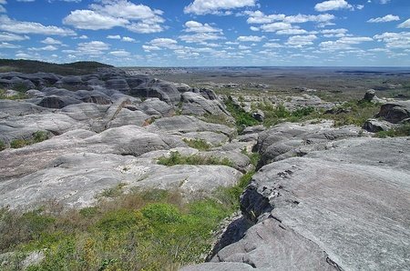
Serra da Capivara National Park
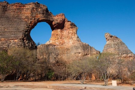
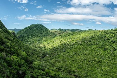
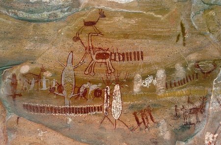
The park was created by decree No. 83,548, issued by the Presidency of the Republic on June 5, 1979, with the purpose of protecting one of the most important examples of the country's prehistoric heritage. Originally covering 100,000 hectares, the protection of the Park was expanded by Decree No. 99,143 of March 12, 1990 with the creation of Permanent Preservation Areas of 35,000 hectares. The administration of the unit is in charge of the Chico Mendes Institute for Biodiversity Conservation (ICMBIO). The Serra da Capivara National Park is an archaeological conservation site with a great wealth of remains that have been preserved for millennia. Cultural heritage and local ecosystems are closely linked, as the conservation of the former depends on the balance of these ecosystems. It is a place with several attractions, a monumental open-air museum, among beautiful rock formations, where you will find spectacular archaeological and paleontological sites, which testify to the presence of prehistoric humans and animals. The national park was created thanks in large part to the work of archaeologist Niède Guidon, who today runs the Museum of the American Human Foundation, the institution responsible for the management of the park. For its historical and cultural value, the park was declared by UNESCO, in 1991, Cultural Heritage of Humanity. The cave paintings are the most abundant, remarkable and spectacular manifestation left by the prehistoric populations that lived in the area of the National Park, since very remote times. The three sites that presented the oldest dates obtained in the National Park area are under-rock shelters. A shelter-under-rock is formed by the action of erosion which, acting at the base of the rocky cliffs, disintegrates the lower part of the walls, causing a protrusion to form at the top. This works as a roof that protects the soil under the sun and rain. As erosion progresses, the protrusion becomes more and more pronounced until, under the action of gravity, it fractures and collapses.
The Serra da Capivara National Park is located in the morpho-climatic domain of the Caatinga, but has many transition forests in the Cerrado on its northern limit. The vegetation is formed by weak but extremely branched bushes, with short and hard branches, with thorny aspects. The trunk of the trees is smooth, the leaves are small and the foliage is light and lets in light. Herbaceous vegetation usually disappears outside the rainy season. The “white forests” of northeastern Brazil or caatingas, as the natives called them, are biogeographic formations characterized by xeromorphic plants (which lose all their leaves in the dry season). It occupies 650,000 km² of Northeastern Brazil, except for the coastal strip, of which only 0.1% are legally preserved. Research carried out in the park resulted in the registration of 33 species of non-flying mammals, 24 of bats, 208 species of birds, 19 of lizards, 17 of snakes and 17 of jewels and frogs. In the park stands out rock cavy, the only mammal endemic to the Caatinga. The largest predator in the entire region of the park is the jaguar.
Serra do Cipó National Park
Serra do Cipó is a geological formation located in the state of Minas Gerais, between the municipalities of Conceição do Mato Dentro, Itambé do Mato Dentro, Jaboticatubas, Morro do Pilar, Nova União and Santana do Riacho. It is part of the geological province of Serra do Espinhaço. Its geological history is complex and dates from the Precambrian period, with its sandy rocks that were formed by marine deposits more than 1.7 billion years ago.
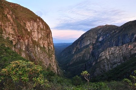
In addition to its geological importance, the Serra do Cipó is considered a natural divider of the hydrographic basins of the São Francisco and Doce rivers. The diversity of its vegetation is very high, and many species are found only there. The fauna is representative and hosts several species threatened with extinction. To preserve this natural heritage, the Serra do Cipó National Park was created. There are altogether one hundred thousand hectares of savannahs, rupestrian fields and forests, in addition to rivers, waterfalls, canyons, caves and preserved archaeological sites. Located in the region, the Serra do Cipó district (formerly Cardeal Mota) is located in the Soberbo stream basin, tributary of the Cipó River basin, which gives the region its name. It belongs to the municipality of Santana do Riacho, whose access is via an asphalt road over a distance of approximately 30 kilometers. The Serra do Cipó district is crossed by the state highway MG-010, paved in 1985, which connects it to Belo Horizonte (less than 100km away) and links it with other cities in the north of Minas. The transformation of Serra do Cipó has been proceeding rapidly, mainly after the creation of the national park. The infrastructure for tourists today has commercial establishments, numerous hotels and inns, structured camping areas.
Serra das Confusões National Park
The park, created on October 2, 1998, has as main objectives the protection of a significant sample of the ecosystems present in the caatinga biome, which is still well preserved in the state of Piauí, still possessing great scenic beauty and high historical value, cultural and scientific. With an area of 823 837 ha, Serra das Confusões is the largest park in Piauí and the northeastern region of Brazil. Its administration is currently in charge of the Chico Mendes Institute for Biodiversity Conservation (ICMBio). The area of this unit is still in a primitive state, with numerous archaeological sites in its caves and caves, including lithography on rocky walls of great historical, scientific and cultural value. It is so called because it changes its configuration according to the daylight. The park has various types of vegetation and climate. These explorers enslaved, expelled the Tupinambás Indians from this region and formed farms in these lands. Until the mid-1950s, there were still Indians located in small families. The region's climate is tropical mega-thermal and semi-arid. It presents a very dissected relief with peculiar rock formations, forming part of the interfluvial zone between Parnaíba and São Francisco rivers basins.
Serra da Cutia National Park
The Serra da Cutia National Park is located in the municipality of Guajará-Mirim, southwest of the state of Rondônia, and is bordered by Bolivia. It has 283 501.38 hectares, and is managed by the Chico Mendes Institute for Biodiversity Conservation (ICMBio).
Serra das Lontras National Park
The Serra das Lontras National Park is a Brazilian national park, located in the state of Bahia, and created on June 11, 2010. It has about 11,343.69 hectares protecting remnants of Atlantic Forest in the state of Bahia. Together with the Una Biological Reserve, it forms an important complex of conservation units in this northeastern region, which protect the Coastal Forests of Bahia and its remarkable indices of diversity and endemism of animal and plant species. The northern muriqui, which is almost extinct in the state of Bahia, and the jaguar are in the forest areas of the park. Serra das Lontras is one of the last places with sufficient size to protect species of large and medium-sized mammals in the Atlantic Forest of Bahia.
Serra da Mocidade National Park
The Serra da Mocidade National Park is an environmental complex located in the central region of the State of Roraima, at the municipality of Caracaraí, in an area neighboring that of the Yanomami Indians. It was created from the decree of April 29, 1998. The area of the park includes drainage parts of the Água Boa do Univini and Catrimani rivers, both tributaries of the right bank of the Branco River.
Serra de Itabaiana National Park
Serra de Itabaiana National Park is an ecological reserve created on June 15, 2005 and managed by the Chico Mendes Institute for Biodiversity (ICMBio). It extends for approximately 8,024.79 ha, covering the municipalities of Areia Branca, Campo do Brito, Itaporanga d'Ajuda, Laranjeiras, Malhados and Itabaiana.
It contains the Atlantic Forest and Caatinga biomes and several species of animals. It is home to 16 species of reptiles, 24 of amphibians, 62 of mammals and 123 species of birds. It is about 38 km from Aracaju, the state capital, and is free to enter. The best known points of the park are Poço das Moças (Girls Well), Serra Cave, Via Sacra, Caldeirão, Hawks Park and Alto da Serra, which have the second highest point in Sergipe, at an altitude of 659 meters.
Well, we finished part 4. From Pico da Neblina to Serra de Itabaiana, we saw amazing parks and places. And the part 5? The finish needs to be the best! Will be the shorter, but needs to top off BNP! What surprises we will see? Just seeing for discover! Liked? So stay open to the news here on my blog! Thank you very much for that minute of attention, and until the next post!
And for the last one, is impossible to say. I will need to search, search, and search...
And of course you would say USA, and India first Proxima :) So, if we were supposing (rightly) these countries first, BRAZIL IS THE MOST BEAUTIFULLLLLLLLLLLLLLLLLLLLLLLLLLLLLLLLLLLLLLLLLLLLLLLLLLLLLLLLL!
And we will have one more part!
Did you like Juquinha’s story (see Serra do Cipó)?