Overseas Territories (United Kingdom)
First published: Sunday January 16th, 2022
Report this blog
- Introduction.
- Anguilla.
- Bermuda.
- British Antarctic Territory.
- British Indian Ocean Territory.
- British Virgin Islands.
- Cayman Islands.
- Falkland Islands.
- Gibraltar.
- Montserrat.
- Pitcairn Islands.
- Saint Helena, Ascension, and Tristan da Cunha.
- South Georgia and the South Sandwich Islands.
- Sovereign Base Areas of Akrotiri and Dhekelia.
- Turks and Caicos Islands.
- Summary.
Introduction.
At it's peak in the early 1920's the British Empire had some form of control over almost a quarter of the earth's land and people, (24 and 23 % respectively). It was said that "the sun never set" on it's territory.
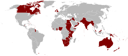
Nowadays, following decolonisation and the independence of most of the former members of the empire there are just fourteen overseas territories left. Most of these are small islands or island groups, tiny plots of land surrounded by other nations or part of international research areas in the Antarctic continent.
There are other parts of the world that are affiliated with the United Kingdom, but are not part of it. I'm talking of the Isle of Man, Jersey and Guernsey. These are known as Crown Dependancies. This means they are almost independant, having their own governments, but rely on the U.K. mainly for defence. But these are not our concern in this blog.
And so to the Overseas Territories, all have the British monarch as head of state, currently Queen Elizabeth II. Most have a degree of independence internally, but all look upon the UK for defence and foreign relations. Anyways, in alphabetical order, here are the fourteen territories....
Anguilla.
Anguilla is a small island just 16 miles long and 3 miles wide (26 x 5 km) on the edge of the Caribbean Sea to the east of Puerto Rico.
The island is named for it's shape, from the Italian word anguilla that means eel.
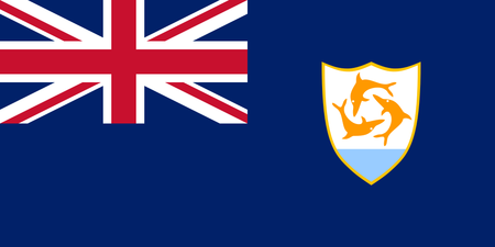
The island's flag contains the Union flag of it's parent nation, the United Kingdom, and the coat of arms of Anguilla which features three dolphins that symbolise friendship, wisdom, and strength. The white background stands for peace and the light blue, the sea.
Anguilla is a tropical island with it's main economy reliant on tourism and it's tax haven status. It is visited by cruise ships at most times of the year.
Although much of the territory's food is imported, although some crops, such as tomatoes, citrus fruits, and onions, are grown, despite the sandy and infertile soil that covers most of the island. Fish also plays a significant part in the island's cuisine.
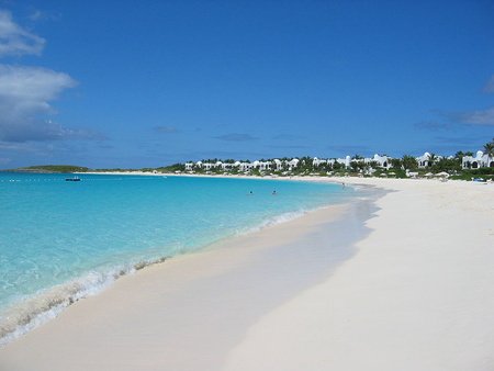
Despite being devastated by hurricanes in 1995 and 2000, tourism has been rejuvinated and in 2014 Anguilla was named the "World's Leading Luxury Island Destination" at the World Travel Awards held on the island.
Bermuda.
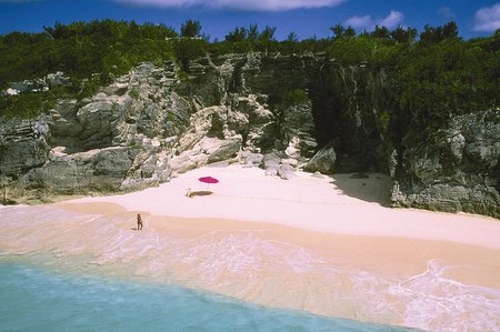
While most people think of Bermuda as a single island it is, in fact, an archipelago of 181 islands. It was originally known as "The Bermudas" or "The Somers Isles". It is situated in the North Atlantic Ocean some 1034 km (643 miles) of the coast of North Carolina, the nearest land.
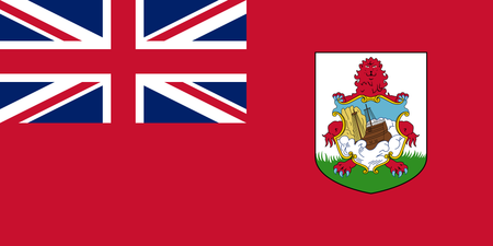
Once again the flag contains the Union Flag and a Coat of Arms, this time depicting a red lion symbolising Great Britain, holding a shield displaying a ship wreck of the Sea Venture, one of a fleet of ships that was deliberately driven onto the shore during a storm, thus saving many lives.
Bermuda is named after the Spanish explorer that discovered it in 1505, Juan de Bermudez. The islands have been permanently inhabited since 1612. First serving as a base for the slave trade and then as a base for merchants, privateers, and the Royal Navy. Tourism has been an important part of the economy since the 19th century.
One cannot mention Bermuda without thinking of "The Bermuda Triangle". An area of the Atlantic Ocean encompassed by the three points of Bermuda, Puerto Rico and Florida, where many ships and planes have disappeared. Whilst there has been many wrecks, and researchers have investigated these extensively, it is now thought that due to weather conditions in the area, the area is no more prone to incident than other areas.
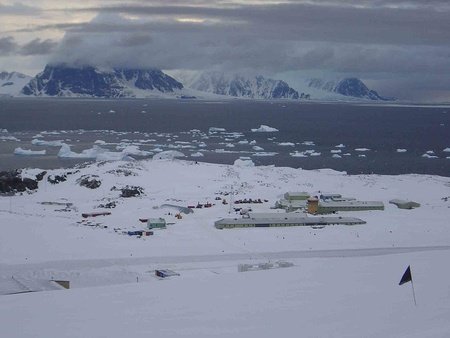
British Antarctic Territory.
B.A.T., or in full, British Antarctic Territory, is a wedge of land on the continent of Antarctica, obviously. The territory was formed in 1962, although claims to the land were made in 1908 and 1917. However, under the current Antarctic Treaty, no nation may make a claim upon land there.
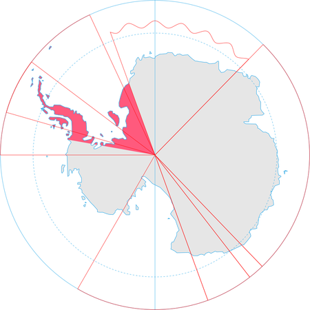
The area is only inhabited by temporary research staff and scientists. There are no permanent inhabitants. Despite this the territory does have it's own flag.
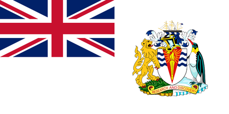
The flag of the B.A.T., like most British territories has the Union Flag and the Coat of Arms. The Arms feature a lion standing on grass representing the home nation, and a penguin standing on ice representing the natural wildlife and environment of the territory. The wavy blue lines symbolise the sea. The whiteness of the flag depicts the snow.
This is the United Kingdom's largest overseas possession. It's southern part is named Queen Elizabeth Land in honour of Queen Elizabeth II. The main base for it's transient population is Rothera Research Station, and there are normally no more than 100 people present during the summer months. This reduces to around 20 in wintertime.
British Indian Ocean Territory.
One of the most controversial of the United Kingdom's territories, the main atoll of Diego Garcia is a shared UK/US military base. There are however, seven different atolls comprising over a thousand islands. All are uninhabited except for military personnel and contractors. The islands are off limits to casual tourists and the media, along with previous inhabitants, the Chagossians. More about them later.
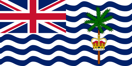
Unlike other flags of Britains overseas lands, this one doesn't feature the Coat of Arms. The wavy blue lines depict the Indian Ocean, and the palm tree through the crown symbolises the nature of the islands.
There is a significant controversy about the native Chagossians (The territory was orginally called the Chagos Archipelago). The entire population of around 2000 natives were forcibly relocated by the British government between 1968 and 1973 to Mauritius (another British possession at that time) in order to build a military base. The atoll of Diego Garcia was then leased to the US for the purposes of building the current airbase. Native Chagossians are still campaigning to be returned to their homeland.
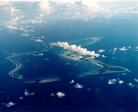
Due to the secretive and classified nature of the territory, little is published about activities in the area. The entire region has now been designated as a "marine reserve" to protect the coral reefs of the territory.
British Virgin Islands.
There are four main islands in this group along with around fifty smaller islands and cays. Only sixteen of them are permanently inhabited. The British Virgin Islands, or BVI for short, lie in the Caribbean Sea to the east of Puerto Rico and the US Virgin Islands. The islands were named by Christopher Columbus in honour of Saint Ursula and the legend of the 11,000 virgins.
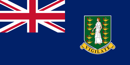
The islands' flag shows the Coat of Arms depicting Saint Ursula surrounded by eleven lamps representing the 11,000 virgins mentioned above. The motto Vigilate means "be watchful" in Latin.
It is thought that the islands were first spotted by Europeans in 1493 when Columbus arrived in the area, however there is evidence of habitation from as far back as 1500BC by Amerindians. Claimed by the Spanish Empire in the early 16th century, the islands changed hands between several nations over a number of years, thus making the region a haunt of pirates and privateers.
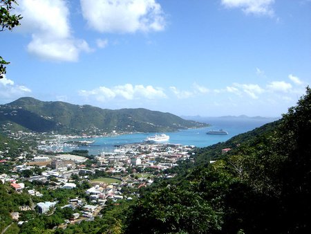
Despite the British ownership of the islands, the currency in use is the US dollar. This is mainly to ease trade between its neighbours. The two main sources of income for the economy is Financial Services and Tourism with a roughly 60% - 40% split. Due to it's tax haven status much of the income comes from offshore company licences. Billionaire entrepreneur Richard Branson, founder of the Virgin group, has a home on Neckar Island, one of many private islands in BVI.
Cayman Islands.
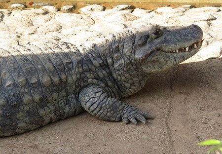
Situated to the south of Cuba and between Jamaica and Mexico's Yucatan Peninsula, the Cayman Islands are another of the overseas territories of the UK that is a tax haven. The state does not charge any tax on income earned or stored there. The islands were discovered by Columbus and initially named Las Tortugas after the many turtles found there. These were soon driven to almost extinction by hunters, and in the following decades the islands became known as the Caymans after the alligator type reptiles found there.
The islands became a base for pirates, shipwrecked sailors and deserters from Oliver Cromwell's army in Jamaica. There was also a large trade in slaves, although slavery was abolished on the islands in 1833.
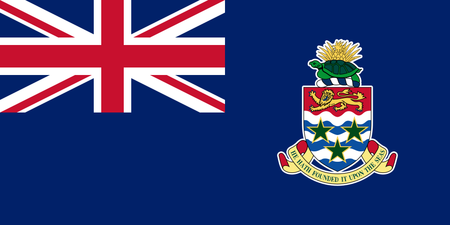
The Coat of Arms on this flag shows three green stars on a blue and white wavy background representing the three main islands on the sea. At the top there is a lion representing Britain and above that a turtle, rope and pineapple. These represent the seafaring history (turtle), a traditional industry (rope), and former ties with Jamaica (pineapple).
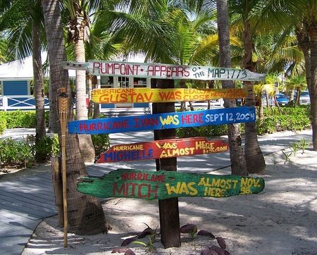
The islands, being low lying, are frequently hit by hurricanes. In 2004 Hurricane Ivan caused damage to around 85% of buildings on Grand Cayman. The islands are affected, on average, once every 2.2 years.
Falkland Islands.
Thrust into the public eye in 1982, when the islands were invaded by Argentina, the Falklands have had their ownership contested since the 18th century when the British established the first settlement there. Situated in the South Atlantic and having a climate that is cold and windy the Falklands have been used as a stopping off point for Antarctic expeditions for many years.
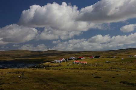
Due to it's climate there are no trees on the Falkland Islands, the largest flora being dwarf shrubs.
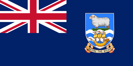
The Coat of Arms on this flag depicts a sheep representing the island's traditional industry of sheep farming. The grass represents the islands on a blue sea. The ship is the Desire, traditionally thought of as the first ship to see the islands. The motto is originally from the ship.
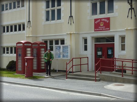
The UK and Argentina both claim sovereignty of the islands. Because of this a referendum was held in 2013 to decide the fate of the territory. The result was overwhelmingly in favour of remaining British. In fact 99.8% of the population voted to stay under UK control. Much of island life in the Falklands is similar to rural life in the UK, with tea and cakes being served most days, and everyone having time for a chat. There are red phoneboxes and postboxes on the islands.
Gibraltar.
This territory is dominated by the Rock of Gibraltar, a monolithic limestone, with a large densely populated town at it's base. It is another disputed possession, this time with Spain, that borders Gibraltar to the north.
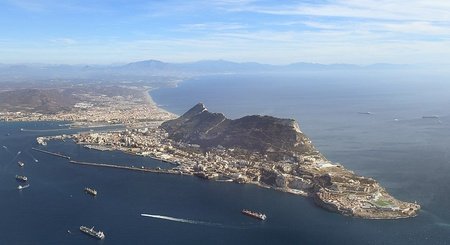
The rock is basically a fortress and many parts are still occupied by the British military forces. There are tunnels and rooms carved into the rock that are still secret and under military control.
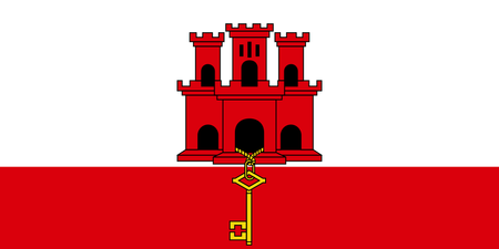
The flag of Gibraltar is unique among the British Territories in that it doesn't contain the Union Flag. The castle does not resemble any of the buildings of Gibraltar but is meant to symbolise the fortress that is the rock. The key symbolises the land being the "Key to the Meditteranean".
The territory relys mainly on tourism to fund it's economy, although online gambling and ship bunkering are also major contributors.
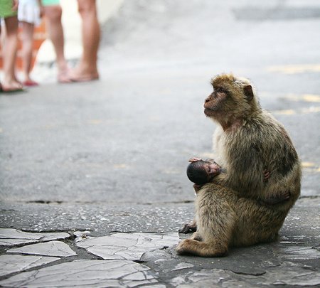
Gibraltar has the only colony of wild apes or monkeys in Europe. It's Barbary macaques are around 230 strong and legend has it that if they ever leave the rock then so will the British.
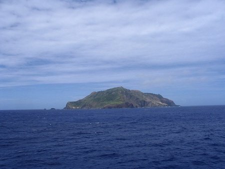
Montserrat.
Nicknamed the "Emerald Isle of the Caribbean" due to it's coastal resemblance to Ireland and the ancestry of many of it's inhabitants, Montserrat is an island divided into two halves.
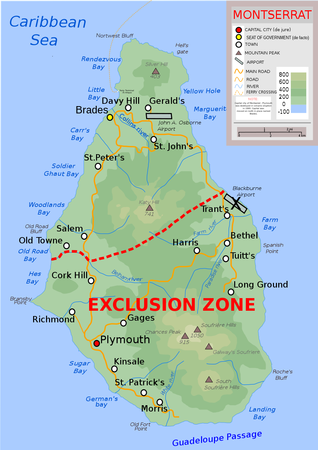
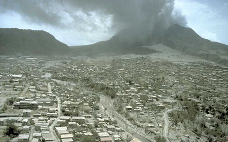
The southern part of the island is a no-go area, except for specific personnel with permission, due to the previously dormant Soufriere Hills volcano that erupted in 1995. The area was destroyed and almost all the population evacuated. The volcano is still being monitored today.
Despite the volcanic activity, the north of the island remains lush and green and largely unaffected. A new capital is under construction in Little Bay near the temporary capital of Brades.
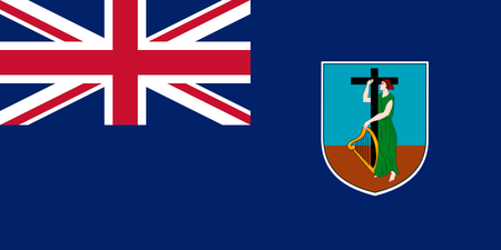
The Coat of Arms on the Montserrat flag depicts a figure of Erin wearing a green dress and holding a golden harp. Erin is the national personification of Ireland and the harp is also a symbol of that country. This symbolises the original settlers that came from Ireland. The cross represents the Christian heritage of the island.
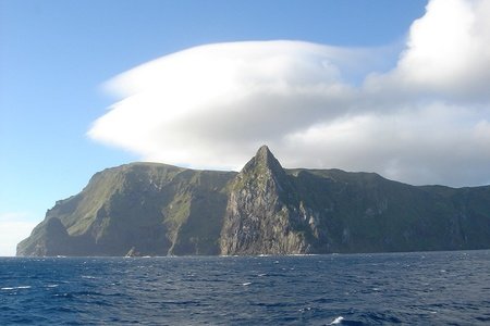
Pitcairn Islands.
The Pitcairn Islands (officially Pitcairn, Henderson, Ducie and Oeno Islands) are some of the most remote islands in the world. They are situated in the South Pacific ocean approximately 5500 km or 3500 miles to the east of New Zealand. Of the four islands only Pitcairn is inhabited, current population is around 50 people.
The islanders are mostly descended from mutineers and Tahitian servants from the British ship HMS Bounty. They arrived on the island in 1790 and it was another 18 years before contact with other seafarers was made. At it's peak the population numbered 233, but this has steadily dwindled mainly due to migration.
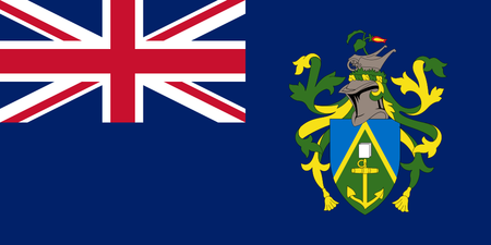
The Coat of Arms depicted on the flag contains an anchor and bible from the ship HMS Bounty. At the top of the crest is a Pitcairn Islands wheelbarrow and a Miro flower. The green triangle shape on a blue background signifies the island rising from the ocean.
The island was infamously brought into the worlds news in 2004 when almost a third of the male population was accused of sexual misconduct against children. Six men, including the island's mayor were convicted and sent to prison.
There is no tax levied on the islands, however every able-bodied person must contribute to the maintenance of roads and other infrastructure as well as agriculture and fishing. Honey and dried fruits are the main products exported, mainly to New Zealand and the United Kingdom. Apparantly the Queen and Prince Charles are particularly fond of Pitcairn honey.
Saint Helena, Ascension, and Tristan da Cunha.
These three islands were grouped together by the British government in 2009 giving them all equal status. Spread over a vast area of the South Atlantic Ocean, the northernmost point on Ascension is 2,263 miles or 3,642 km from the southernmost point on Gough Island.
Because this territory is made up of three previously separate areas, there are three different flags.
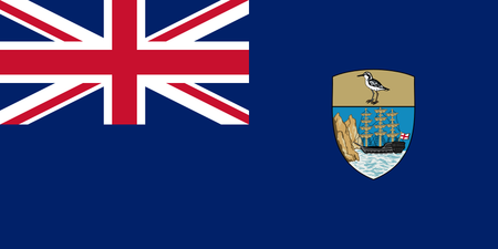
Saint Helena. The Coat of Arms depicts a three masted ship flying the flag of England next to a rocky cliff face symbolising the island's discovery. The bird is the St.Helena plover known locally as a wirebird.
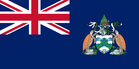
Ascension Island. Only adopted in 2013, the flag contains the Coat of Arms that was itself only designed in 2012. Featuring turtles that are found in the seas around the island, along with seabirds surrounding a green triangle in a field of blue and white wavy lines symbolising the island within the ocean.
Tristan da Cunha. Another relatively new flag, this time adopted in 2002, the Coat of Arms depicts a Tristan longboat above a naval crown supported by two Tristan rock lobsters that are found in the seas around the island. The centre contains four albatrosses and a blue and white wedge. Cunha is Portugese for wedge.
The islands are ideally placed to monitor shipping throughout the Atlantic Ocean and as such they have a large military prescence. Both the UK and US maintain listening stations and bases on the islands. However, Tristan da Cunha is only accesible by sea, there is no suitable land for even a small airstrip. Ascension Island is used as a connecting and refuelling point for flights between the UK and the Falklands. It was also a designated landing place for the Space Shuttle during it's space program.
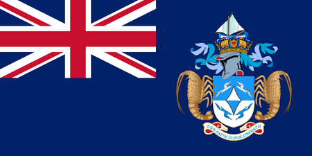
South Georgia and the South Sandwich Islands.
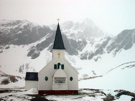
In the early part of the 20th century, South Georgia was developed from a seal hunting base to a major whaling station. A Norwegian fisherman established the first land based station and permanent habitation at Grytviken in 1904. Although the last whaling operation ended there in 1965, much of the abandoned factory structures still exist, albeit in a dilapidated state. The Norwegian Lutheran Church, however, has been restored and is visited by many tourists each year.
South Georgia saw action during the Falklands War when Argentina positioned an invasion force on the island. Nowadays only weather station personnel and scientists are resident on the island on a temporary basis. Cruise ships frequently call to view the abundant wildlife around the islands and the history of the area. Explorer Sir Ernest Shackleton is buried in Grytviken.
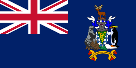
The Coat of Arms shows a golden lion symbolising Britain, along with a seal and penguin, both native to the islands. The reindeer depicted are not a native species, but were introduced some time ago and have thrived. There are currently two large herds on South Georgia. The motto translates as "Let the lion protect it's own land"
The South Sandwich Islands are a group of eleven volcanic islands situated between South Georgia and the Antarctic continent. They are uninhabited, although automatic weather stations are located there.
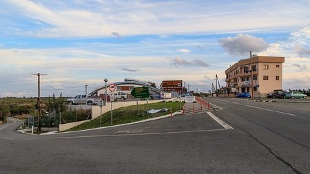
Sovereign Base Areas of Akrotiri and Dhekelia.
Situated on the island of Cyprus, this territory consists of two military bases plus some other small pockets of land. Given to the UK in 1960 under the independence treaty, they remain important strategically due to their position near to the Suez Canal and the Middle East.
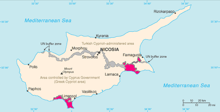
The bases were important during the coup in 1974 that saw Turkey invading the northern part of Cyprus to protect it's citizens. Many Turkish Cypriot refugees were granted safe passage through the military areas and offered transport to the north. Following this time there was a plan to close the bases due to costs, however the US agreed to contribute and joint operations betwen the two countries continue to this day.
The base areas use the same currency as the rest of Cyprus, originally the Cypriot Pound and now the Euro, making it the only soveriegn territory of the UK to officially do so.
Akrotiri and Dhekelia are essentially just military bases in a similar way that the US has bases in the United Kingdom and elsewhere. The UK also has bases in other parts of the world such as Belize, Canada and Kenya, although these are primarily used for training purposes.
Turks and Caicos Islands.
Last but not least, these islands lie to the north of Cuba and the island of Hispaniola in the West Indies. For many years they came under the control of the British Empire lands of Jamaica and the Bahamas. When they gained independence the Turks and Caicos became an overseas territory with their own partially limited government.
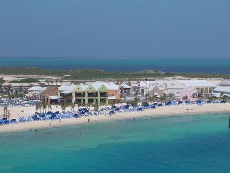
The main source of income on the islands comes from tourism, and this has been boosted by the building of a new cruise terminal. Also many wealthy and famous celebrities, including Dick Clark and Bruce Willis, have owned homes on the island. To boost tourism, the local government has organised music festivals and built up-market resorts.
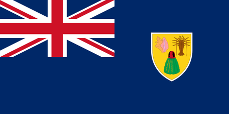
The Coat of Arms depicted on this flag contains images of a conch shell, a spiny lobster, and a Turk's Head catcus. All represent the flora and fauna of the islands.
The islands have one of the longest coral reefs in the world and also the world's only conch farm.
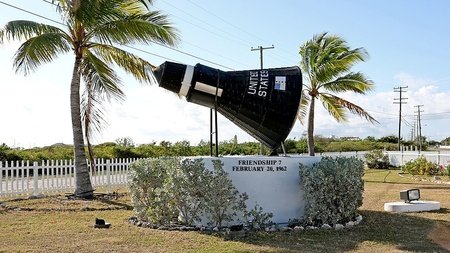
From 1950 to 1981, the United States had a missile tracking station on the island of Grand Turk, this was used by NASA during it's early space program. After his three successful earth orbits in 1962, John Glenn splashed down in the nearby ocean and was taken ashore on Grand Turk.
Summary.
So there you have the overseas territories of the United Kingdom. Spread throughout the globe, and as diverse as you can get. From hot tropical islands to frozen wastelands, from popular tourist destinations to remote inaccesible rocky islets. Some come under mainly military control, whilst others are run almost as independent countries, leaving only defence and foreign relations to the United Kingdom government.
Together the territories support a population of around a quarter of a million people and cover a land area of about 660,000 square miles (1.7 million square km), although most of this is the Antarctic territory.
"What's next ?", I hear you ask. Well, I have a few ideas for a new blog. Or I could continue this series and write about the overseas territories of other countries. I haven't yet decided if this will become a series or just be a stand alone blog. I do know that it will probably be a geography based blog, because that's what interests me.
Anyway, enough rambling, I'll just proof read this and then publish it.
See you soon and Stay Safe !
The dragon and lion flag
Not adding United States of Brazil flag (temporary one used during 4 days) because, ughSorry to hear about the tragedy in your area recently with the rockfall at the lake. RIP to all involved.
I'm probably completely wrong on this and it's just about the money..lol