Five Islands of Africa - Part 1
First published: Sunday July 31st, 2022
Report this blog
Introduction
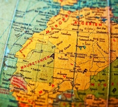
This blog will be our first foray into what used to be called the "Dark Continent". It was named this because the continent was not explored much at all until relatively recently. The Sahara Desert provided a natural barrier to exploration by European adventurers. Coastal areas were discovered but inland was unknown until the 19th century. In the map shown below from 1813, you can see that many parts of sub-Saharan Africa are simply labelled "Unknown Parts"

Enough chit-chat lets get going with our first island, or in this case group of islands.....
Kerkennah Islands (Tunisia)
This small group of ten islands is situated in the Gulf of Gabes around 20km to the east of the large town of Sfax. There are two main islands, Chergui and Gharbi. The main town of Remla has a population of about 2,000 people.

The first inhabitants were the Berbers from mainland Africa, but they were taken over by the Roman Empire to control shipping in the bay. In 2BC, the first emperor Augustus, exiled his married daughters lover to the island for fourteen years.
In 532, a monastery was built by Saint Fulgentius.
The island's population was drastically reduced in the 1980's following a severe drought. Clean drinkable water was drying up and irrigation systems were failing. Most of the population was forced to leave for the mainland.


The land on the islands is arid and agriculture consists of residents goats and chickens. Tourism is the main part of the economy, however this is mostly Tunisian nationals. There are holiday homes built on the islands by wealthy locals. Remla has a three day Octopus Festival coinciding with the start of the octopus fishing season in March each year.

Getting to the island is by car ferry from Sfax, taking around an hour and a half. Once on the island there are few roads, but many dirt trails suitable for mountain bikes.
The Tourism Tunisia has a Travel Guide to the islands.
Habibas Islands (Algeria)
The Habibas Islands are a small group of islands, islets and rocks off the coast of Algeria, about 12 km or 7 miles from the city of Oran. Their origin is volcanic. The two main islands are called Charguia and Gharbia.

The islands have very little history, they are uninhabited, although there is a lighthouse and several buildings. The lighthouse was built in 1878 during the French occupation of Algeria.
The islands are now protected as the "Iles Habibas Marine Nature Reserve", and as such cannot officially be visited. However local boat owners have been known to take tourists.
The two main bird species that are protected are Eleonora’s Falcon, and Audouin’s Gull.


As stated above the islands are off limits to tourists, local boats can be taken to sail around the islands, and diving is still allowed at certain sites. Most boats depart from Oran.
The nature reserve has it's own page on the Algeria.com website, although there is little information available about this small archipelago.
Perejil Island (Morocco / Spain)
You may be wondering why the heading reads "(Morocco / Spain)". The reason is this island, despite only being 200m or 660ft from the Moroccan mainland, is disputed between the two nations. Both Spain and Morocco claim ownership of this tiny, barren island.

The name Perijil directly translates into English as Parsley Island. It's original Berber name was Tura, which means "Empty". It is also known as Leila Island in Morocco.
In 1415, the island along with the nearby city of Cueta, was taken by Portugal from the Berber Empire. Over a hundred years later in 1580, the island came under Spainsh control following the creation of the Iberian Union. When the union broke up in 1640, the island remained under Spanish control.

Up until 2002 very few Moroccan, or indeed Spanish, citizens had heard of Perejil Island. This changed on the 11th of July in that year when a number of Moroccan soldiers set up a base on the island. The initial reason given was to monitor illegal immigration.
On the 18th of July Spain launched Operation Romeo-Sierra and retook the island later the same day. There was little resistance from the forces on the island.
With mediation assistance from the United States, both sides agreed to return to the status quo of disputed sovereignty over the island. Neither side has tried to set up bases since, although in 2014 the Spanish requested the Moroccan forces to land on the island to expel sub-Saharan migrants.
The island remains uninhabited, although local farmers graze goats there.
Boat tours around the island can be organised from the Spanish city of Cueta.
The story of the conflict can be read here.
Kunta Kinteh Island (Gambia)
Formerly known as James Island, named after King James II, Kunta Kinteh Island is situated in the Gambia River about 30km inland from it's mouth on the Atlantic Ocean. It is a UNESCO World Heritage Site. (Sorry Kingsfisher for hi-jacking one of those, especially if you were thinking of using this one)

This island has been in use as a military base since around 1650 when a vassal state of Lithuania built a fort there, although the first Europeans to have contact with the island was in 1456 when Portugese explorers buried a crew member on the island.
When gold was discovered in the river the island changed hands several times over the following years between Dutch, French, Swedish and pirate hands until it finally came under the control of the British in 1664.

The island was an important trading post in the gold, ivory, and later the slave, trade when it was under the administration of several British companies.
A six gun battery and further fortifications were built after the Slave Trade Act of 1807. These were built to enforce the Act and prevent slavery.

The name was changed to Kunta Kinteh Island in 2011 by the Gambian president to give the island a more Gambian name. The main character in Alex Haley's book and subsequent TV series, Roots, is Kunta Kinte, a fictional story based on real events of one of the author's ancesters.
A ferry runs from the north bank of the River Gambia, and guided tours are available to both the island and the Slavery Museum on the mainland.
This YouTube video is a tour of the island.
Boa Vista (Cape Verde)
Cape Verde in general is a group of islands situated around 700km(430miles) off the westernmost point of Africa. Boa Vista is the nearest island to the continent. It is mainly known for it's beaches and for it's nesting areas for sea turtles.

The then uninhabited island was first discovered in 1460 by Portugese explorer Diogo Gomes but it wasn't until the end of the 16th century that settlers arrived.
The first settlement was established in 1620 to exploit the nearby salt deposits. The collection of salt relied heavily on the slave trade which wasn't abolished completely until 1876.


As can be seen from the above two pictures, Boa Vista is quite barren. The main economy was salt collection and date production. Nowadays, dates are still cultivated but the main industry is tourism. This was increased drastically with the opening of the International Airport in 2007.

The island has it's own official website.
Summary
So there we are. Five islands of Africa. Or at least the northwest of Africa. I am thinking that I shall probably be making at least four parts for Africa, maybe five, we'll have to see how it goes. Next time we shall be continuing our quest around the coast starting in Senegal and around the edge of the Gulf of Guinea.
I think I have now got back into my stride on these blogs, this one hasn't taken anywhere near as long as the last. Work has settled down a bit so I am getting a little more free time again, thankfully !
I'll end by paraphrasing a quote from the classic 1942 movie "Casablanca" starring Humphrey Bogart and Ingrid Bergman...
"Of all the blogs, in all the websites, in all the world wide web, you have to read mine."
Perhaps it is a combination of things.
End of the pandemic so people are out and about more.
Summertime and people on holiday.
Schools closed so no school computers available.
I know I have less comments than a few months ago. It doesn't really bother me but it's nice to know someone is reading my ramblings.
I prefer blog writing now than quizmaking if I'm honest, so I don't want the RUB to become endangered or extinct.
"Out of all comments on JetPunk, on all the websites on the internet, you have to read and like mine" - The something BCE poem Iliad
I think the quote is more Homer Simpson than the other Homer !