Five Islands of Africa - Part 2
First published: Saturday August 6th, 2022
Report this blog
Introduction
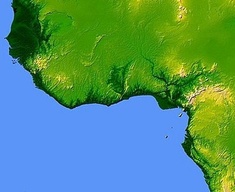
The second African edition has arrived. We are continuing around the continent and this time we are in a region that, rightly or wrongly, historically used to be called "The Slave Coast". Thankfully most of the world has moved on from the traditional idea of slavery, although there is a worrying trend around the world of so called "modern day slavery". But enough of that, it's not why we are here. The area I'm talking about can be seen in the picture below. Some of the names on this old map are very politically incorrect for this day and age. If anyone is offended I apologise in advance.

Here's the first island....
Fadiouth (Senegal)
Fadiouth is the name of a village and island that is part of the town of Joel-Fadiouth south west of the nation's capital, Dakar. The two towns are connected by a bridge that leads from the mainland town of Joel to the island which is made of clam shells.

The origins of the village are disputed, but the earliest evidence of habitation is from the Berber dynasty in the 11th century.
In the early 17th century the island was a trading post run by Portugese Jews trading between West Africa, Portugal and the Netherlands. They were under the protection of a local tribal chief, who allowed them to be open with their religion, much to the annoyance of the Catholic Government of Portugal.

Fadiouth became an entry point for Christian missionaries as early as the 17th century, however due to local resistance to their evangelism, they delayed much of the ingress of religion to Africa for at least a century. A mission was finally established in 1850 with the first priest not ordained until thirty-five years later. The majority of the islanders are Christian (around 90%) in a land that is predominantly Muslim.
The island is mainly mangroves with baobab trees and acacias. The main industry is fishing (Joel has the largest fishing port in Senegal), agriculture and tourism. The island has millions of shells which are used by locals to decorate graves.


Fadiouth is reached via a wooden bridge from Joel, no cars are allowed on the island. Joel is easily reached from most of Senegal.
Here is a short travelogue about Fadiouth.
Bolama Island (Guinea-Bissau)
Bolama is the closest island to the mainland in the Bissagos Islands group just off the coast of Guinea-Bissau about 26 km or 13 miles south of the capital Bissau. It shares it's name with the largest settlement on the island.
The island is surrounded by mangrove swamps and is known for it's production of cashew nuts.

Although the island was regularly visited by locals, it was thought to be uninhabited in 1792 when it was visited by a British Royal Navy officer who attempted to repatriate former slaves on the island. Unfortunately most of the residents died and the survivors fled to Sierra Leone.
The island was disputed between Portugal and Britain for over forty years before it was given to Portugal in mediation hosted by Ulysses S Grant, the US president. The town then became the capital of Portugese Guinea. It was transfered to Bissau, a trading centre since 1687, in 1941 when a lack of fresh water was causing problems.

The town and island became a seaplane hub for a while, a crash in 1931 is commemorated with a memorial in the town. Following the capital's move to Bissau the town slowly decayed. A fruit canning factory was built with Dutch foreign aid, but due to the lack of fresh water this eventually closed down. Several buildings are now in ruins, and are home to colonies of fruit bats , that darken the skies when flocking to the mainland at dusk.


Bolama Island is accesible by local weekly boat from Bissau or by small canoe from Sao Joao.
This travelogue has an excellent report and pictures of a trip to Bolama.
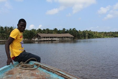
Sherbro Island (Sierra Leone)
Sherbro is situated just off the coast of Sierra Leone, seperated by the Sherbro Strait in the south and the river of the same name in the north. It is approximately 600 square kilometres (230 sq.miles) in size, and is famous for its turtle breeding grounds and tarpon fishing. The island has been earmarked by the Sierra Leone government for tourism development.

The island was used as a trading post in the 17th century by a British company, the Royal African Company whose origins began in Liverpool, England. Initially trading in gold and minerals, the company soon began to trade in slaves. Following the Abolition of Slavery Act the island was used as a resettlement centre for freed slaves from the Americas prior to the establishment of the nation of Liberia.

The island is famous among the fishing fraternity for it's record braking tarpon, which can grow up to 8 ft (2.4 m) long and weigh 280 lb (127 kg). The record for this fish is currently 286 pounds and 9 ounces or around 130 kg. By comparison the weight of a Lambretta scooter is about 230 pounds !

You can get to the island by boat from Yargoi on the mainland, the journey takes approximately two hours.
This report from Fly Fishing Journal has some decent pictures, although it is heavily concentrated on the fishing aspect obviously. The report is also from 1992.
This Visit Sierra Leone travel site has a description of a tour to the island with further pictures.
Bushrod Island (Liberia)
Being part of the suburbs of the nations capital, Monrovia, this island is far from remote. It is connected to the mainland by several bridges and can even be viewed on Google Street View. It contains the Freeport of Monrovia on it's western coast, the main entry point for goods from around the world into Liberia.

Originally settled by the Dei people from the 16th to 19th centuries, Bushrod was a low lying mangrove swamp. In the 1820's Bushrod was the home to freed slaves from Georgia, USA.
The island is named after Bushrod Washington, who was a nephew of George Washington and the first president of the American Colonization Society, a society that advocated the freeing of African American slaves.


The majority of residences on the island are concentrated in four towns, although most are what is known as "Shanty Towns" where up to 10,000 people share just two water taps.
Getting to the island is easy, the main highway north from Monrovia, United Nations Drive, crosses the entire island from south to north.
This YouTube video has an eight minute journey through Bushrod Island. (After you skip the ads obviously).
Île Boulay (Ivory Coast / Cote d'Ivoire)
The fifth island in this edition of my blogs is situated in the Ébrié Lagoon near to the economic capital, Abidjan. Despite it's proximity to the large city, the island maintains a relatively low population of around ten thousand inhabitants. There are many vacation cottages for the more affluent residents of the city.
Since 2008 there have been plans to extend the port of Abidjan to the island, and the government of neighbouring country, Mali, have been constructing warehouses for the trans-shipment of goods bound overland to the border. There are plans to build a bridge for access. All of these plans have had considerable opposition from the residents of the island, fearing that the present pollution will increase many fold making the island virtually uninhabitable.


Boulay can be reached from Abidjan by boat. The journey takes just 15 minutes.
This travelogue by Down to Earth Travellers has some excellent photos of a day trip to the island.
Summary
Phew, the second one done already, I must have got back into the stride of things. Perhaps, encouraged by some of the other excellent blogs in the RUB. There did seem to be a point where blogs were drying up, but now it has come back again. Let's hope it stays like this, and some more excellent blogs are forthcoming from JetPunk members like HeyItsRose18, Yesse03, and Kingsfisher. If I haven't mentioned others it is purely because I like travel blogs. There are some excellent blogs from other users, but they are not really to my taste. That is a personal observation and applies only to me, I'm sure they are really good blogs and I'm sure many readers enjoy them, just not my thing, Sorry!
Anyway, I've rambled on enough for now, the dogs want to go out, I have the grass to mow in the garden, and the evening meal to prepare for the wife when she finishes work in about three hours. But enough of my problems, see you next time.
Oh, and in the words of the character Karen Blixen played by Meryl Streep in the 1985 movie, Out of Africa, "The Earth was made round so that we would not see too far down the road."
See y'all soon !
:D