Five Islands of Mainland Southeast Asia
First published: Saturday May 20th, 2023
Report this blog
Introduction
Moving on around the globe, sorry flat earthers it has been proven scientifically that the earth is round, we head into what used to be called Indochina. Now generally referred to as Mainland Southeast Asia to differentiate the area from Maritime Southeast Asia.
The term Indochina began in the early 19th century as a way of describing the cultural influences of the area. There were various names for the area such as Further India and the Peninsula beyond the Ganges but none gained enough popularity to be used often. The French called their colony in the area French Indochina, this area covering what is now Laos, Cambodia, and Vietnam.

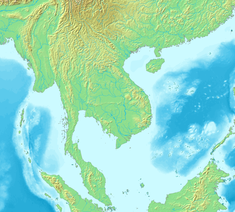
For the purposes of this blog series Indochina is a perfect fit. The area incorporates the countries of Myanmar, Thailand, Cambodia, Laos, Vietnam and the peninsular part of Malaysia. Six countries. "But, you only need five !" I hear you shouting. "But Laos is landlocked" I reply smugly.
Of course, Laos does have islands, particularly in the Nam Ngum Reservoir and the Mekong River, but there is little information available about these places. Picture below so Laos doesn't feel left out of the party.

Ramree Island (Myanmar)
Ramree Island is situated just off the coast, approximately due east of the capital Naypyidaw. When I say "Just off the coast" it is literally that. It is separated from the mainland by a canal like strait that in parts is less than 150 metres wide, that's about 500 feet for those of you that still use Imperial measurements. In the Burmese language it is known as "ရမ်းဗြဲကျွန်း" or Yanbye Island.

The main town of Ramree is in the middle of the island and has a population of around 9,500 people. The island was a trading post from the 15th century for several hundred years.
During World War II, the island was the scene of a major battle between British and Japanese forces as part of the Burma Campaign. the battle occurs in January and February of 1945.


The offensive to take the island from the Japanese led to around 900 soldiers retreating to join larger forces in the south. However, this meant moving through mangroves, mud and jungle. It was reported that a high number of casualties were attacked and killed by saltwater crocodiles. In fact the Guinness Book of World Records at the time called it "the worst animal attack ever", although this was later disputed and the troops probably succumbed to disease, hunger and gunfire as well as crocodiles.
There is nowadays a pipeline crossing the island that supplies China with oil and gas from the Middle East via India, thus reducing the need for ships in the dangerous seas of South Asia.
The island is accessible via road, the Mongkraung Bridge crosses the strait, and by air to the airport in the north of the island.
This webpage has several photos and some more history of the island.
Koh Mak (Thailand)
Koh Mak is a small vaguely cross shaped island on Thailand's coast on the eastern side of the Gulf of Thailand. It is home to around 400 locals and is renowned for it's beaches. In fact, in 2006 it was placed in the UK's Sunday Times list of the Top 10 beaches worldwide.

The first settler on the island was a Chinese Affairs Officer during the reign of King Rama V, who ruled between 1868 to 1910. He, the Chinese resident not the King, established a coconut plantation that he later sold to another Chinese Affairs Officer named Luang Prompakdii whose descendants still own the land today. This family established rubber plantations as well as the original coconut farms.
Tourism didn't feature in the islands economy until 1974 when bungalows were built in the east of the island. However, due to the lack of infrastructure and communication, the first resorts were not built until 1987. There are currently around fifteen tourist resorts around the island.

There are no pubs or clubs on the island and is considered a peaceful place to live or visit. Tourists are encouraged to join litter picking groups on the beaches under a scheme called Koh Mak Trash Hero.
Koh Mak can be reached by speedboat from the pier at Laem Ngop on the mainland to the north of the neighbouring island of Koh Chang.
The island has its own website.
Koh Tang (Cambodia)
Koh Tang is located about 32 miles or 52 km from the mainland of Cambodia. It is mostly forested but with unspoilt beaches and plenty of dive sites on its coral reefs.

The almost idyllic setting in the above picture belies the island's grim history.
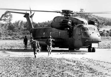
Koh Tang was the site of the last combat action of the Vietnam War, and the only ground battle between the US and the Khmer Rouge.
In May 1975, the Khmer Rouge kidnapped over 500 Vietnamese civilians from a neighbouring island. they were forced into hard labour until they were all executed.
Later in the same month, US Marines attempted a rescue of the crew of the SS Mayaguez, that were believed to be on the island. They were in fact on the mainland and subsequently released, however during the operation three helicopters were shot down and several combatants on both sides were killed.

Three years later in 1978, August 13 to be exact, a Chinese sailing junk by the name of Foxy Lady was blown of course and was sheltering to the west of Koh Tang Island. It was fired upon by Khmer Rouge gunboats killing a Canadian crewman. Two other members of the crew, an Englishman and a New Zealander, tried to escape by diving overboard but were captured. Both men were taken to the notorious S21 prison in Phnom Penh, where they were both tortured and executed.

Koh Tang is now partly a military base and there are no permanent civilian residents, however the island can be visited and overnight stays are possible despite there being no hotels or facilities. The island can be reached from Sihanoukville on the mainland. The journey by dive boat can take several hours, but local speedboats make the journey in around an hour and a half.
This Dutch website, in English, has some pictures and details of the island.
Côn Sơn Island (Vietnam)
Con Son Island is the largest and only inhabited island of the Con Dao archipelago that is located off the coast of southern Vietnam.

The islands have been known for many centuries, the first known reference was by Ptolomy (100-170AD) who referred to them as the Islands of the Satyrs. They were visited by Marco Polo in 1292 as part of his voyage from China to India.
In 1705, the East India Company of England founded a settlement there, however this was destroyed in 1705. The island was then ceded to the French as part of the Treaty of Versailles of 1787.
In 1861, the French colonial government built the Con Dao prison to incarcerate political prisoners. It was still being used for the same purpose when it closed at the end of the Vietnam War.

The prison is now a museum open to the public.
Con Son Island is now an up and coming tourist destination, although it is still relatively quiet and "undiscovered".


Part of the island is a National Park and there are temples and numerous beaches to explore.
The island can be reached by air from Hanoi, Ho Chi Minh City, and several other regional airports. Alternatively, you can take a ferry(12 hours) or speedboat (3 hours) from various points on the mainland.
This Vietnamese Tourist Board website has more photos and information about the island.
Jerejak Island (Malaysia)
Jerejak is a small island off the eastern coast of Mainland Malaysia, it nestles in the shadow of the much larger Penang Island.

The island was originally supposed to be the location of a military post to protect a proposed township on Penang Island, however with the growth of George Town on the mainland, the island became a leper colony and quarantine station in 1868. This facility continued until the 1960's, it was in use during World War II due to an increase in the number of tuberculosis patients.

Following the sanatorium's closure it was converted to a maximum security prison, earning the island the nickname "Alcatraz of Malaysia". The prison was closed in 1993.


The island is now known as a tourist destination, with several resorts being built. Controversially the first resort was built by demolishing some of the historic buildings around the area of the former leper colony.
Jerejak Island is accessible via a short ten minute ferry ride from Penang Island, ferries run continuously throughout the day and cost very little.
This blog has some photos of the island as it is now, along with some of the attractions on offer.
Summary
Wow, my third blog in a weekend, I'm on fire! I think the rest I took from blogging has done me good.
Anyway, another "Five Islands" done and dusted, I can see the light at the end of the tunnel, metaphorically.
Next on the list will be Maritime Southeast Asia, which conveniently, also has six countries including Malaysia. We've already done that nation that leaves five (6-1=5), Indonesia and the Philippines are the two largest, then there are the three smaller nations of Singapore, Brunei and Timor l'Este or East Timor as it is generally known.
Until next time mes amis, goodbye, adios, au revoir, and "selamat tinggal" .(Malay, in case you were wondering, tata)
Interestingly, today there were a lot of islands where battles took place
Circumstances allowed extra time on the computer and I had two of the blogs partly written.
With regard to the battles, it just seemed to work out that way, I didn't purposely look for them.