Minas Gerais: Marvelous Sunrises, Amazing Surprises - Part 2
Last updated: Saturday August 7th, 2021
Report this blog
We're back, with the second part of 3, of blogs about the gorgeous state of Minas Gerais. We saw the fascinating history of Minas on our last post. Now, we'll see more about geography. This include the topography, hydrography, climate, enviroment and biggest cities Let's go?
Minas Gerais is one of the 27 federative units in Brazil, located in the Southeast Region of the country, bordering the states of São Paulo to the south and southeast, Rio de Janeiro to the southeast, Mato Grosso do Sul to the west, Goiás and the Federal District to northwest, Bahia (to the north and northeast) and Espírito Santo to the north and east, with a total of 4,727 km of border line. The state area, according to the Brazilian Institute of Geography and Statistics (IBGE), is 586 522,122 km² (slightly less than the sum of the areas occupied by Portugal and Spain together, 596 994 km²) and is equivalent to 6.89% of the Brazilian territory, being the fourth largest state in territorial size (after Amazonas, Pará and Mato Grosso), of which 2,525.8 km² are in urban perimeter. The linear distance between the state extreme points is 1,248 km in east-west direction and 986 in north-south direction.
Topography
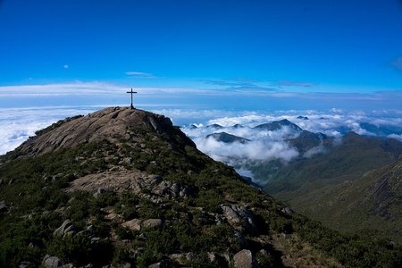
Most of the Minas territory has altitudes that range between 900 and 1 500 meters, with predominance of plateaus with escarpments and depressions, most notable in the central region. The highest point in the state is Pico da Bandeira, located on the border with Espírito Santo, with 2,891 meters (9484 ft.) of altitude (the third highest in the country), followed by Pedra da Mina, Pico das Agulhas Negras, and Pico do Cristal.
In addition to Serra do Caparaó, where Bandeira is located, other mountainous massifs deserve prominence in Minas Gerais territory, among them Serra do Espinhaço, which runs from the center towards the north of the state to the limit with Bahia. To the south, delimiting the border with the states of São Paulo and Rio de Janeiro, is the Serra da Mantiqueira, in which are located some of the highest peaks in the country, such as the Agulhas Negras with 2,787 meters (9143 ft.) of altitude. Other smaller mountain ranges are spread across the state, the most notable being Serra da Canastra, Serra do Cipó, and Serra do Lenheiro.

Hydrography
In the hydrographic network, among the main rivers of the state of Minas Gerais are Doce, which rises between the slopes of the mountains of Mantiqueira and Espinhaço and travels 853 km until it flows into the Atlantic Ocean, in Espírito Santo; the Grande, whose source is in the Serra da Mantiqueira, in the municipality of Bocaina de Minas, covering 1,360 km to the Paranaíba River, thus forming the Paraná River (in the state of São Paulo); Paranaíba, which spring is in Mata da Corda, in the municipality of Rio Paranaíba, and has approximately 1 070 km until form the Paraná River with the Grande; São Francisco, which is born in Serra da Canastra, travels 2,830 km, cutting through Bahia and passing through Pernambuco, Sergipe and Alagoas until it flows into the ocean, its waters being essential for tourism, leisure, irrigation and transportation in several cities, and, finally, Jequitinhonha, which is born in the Serra do Espinhaço, in Serro, and travels 920 km to its mouth in the Atlantic, at Belmonte, Bahia.


Other important rivers in the state are Mucuri, Pardo, Paraíba do Sul, São Mateus and das Velhas. The Rio Doce State Park is home to the largest lake system in the state. However, there are important reservoirs of hydroelectric plants, such as Furnas, in the south, and Três Marias, in the center of the state. Due to the large number of springs, the state is known as the water tank in Brazil, with many of these rivers having energetic, agricultural and tourist relevance, with a large presence of hydroelectric plants, irrigation channels and leisure activities. 16 hydrographic basins make up the state of Minas Gerais, the largest of which is that of São Francisco, which covers an area of 2.3 million km² in the state. Four hydrographic regions encompass the territory of Minas Gerais, namely São Francisco, the East Atlantic, the Southeast Atlantic, and Paraná. In the dry season, a lower volume of water is observed, and in the north of Minas Gerais some courses dry up during periods of drought. In the rainy season, sometimes, floods.
Climate

In the state of Minas Gerais, three distinct types of climate predominate: the subtropical higland (Cwb, according to the Köppen-Geiger climatic classification), which occurs in the higher regions of the Canastra, Espinhaço and Mantiqueira mountains and in small areas nearby to the cities of Araguari and Carmo do Paranaíba, with droughts in winter and mild temperatures during the year; the humid subtropical with dry winter (Cwa), observed to the north of the Espinhaço and Cabral mountains; and the tropical savanna (Aw), which predominates in the Triângulo Mineiro, in the Zona da Mata, Vale do Rio Doce and in almost the entire northern half of the state, having a dry season in winter and abundant rains in summer, with annual rainfall between 750 mm to 1 800 mm. According to the Northeast Development Superintendence (Sudene), the semi-arid climate is present in 88 Minas Gerais municipalities, all in the north of the state, many of which are in the process of desertification.
Vegetation and Environment
In Minas, three biomes are present: Cerrado (savanna), Atlantic Forest, and Caatinga. The cerrado is the predominant biome, being observed in 50% of the territory, most present in the western portion of the state. The vegetation is predominantly undergrowth, composed of grasses, shrubs and trees, having as representatives of the anteater fauna, armadillo, tapir, rattlesnake and the bush dog, in addition to endangered species, such as the maned wolf, the Pampas deer and the Brazilian Merganser. The Atlantic Forest occupies the second largest occurrence area in Minas Gerais, predominating in the regions of Zona da Mata, Campos das Vertentes, South, Metropolitan Belo Horizonte, Vale do Rio Doce and Vale do Mucuri, however it was heavily devastated, currently occurring in restricted areas. The vegetation is dense and, due to the high pluviometric index, quite green, being possible to find bromeliads, vines, ferns, orchids and lichens and, in the fauna, monkeys, sloths, capybaras, jaguars, macaws, parrots and hummingbirds. Finally, the Caatinga, cover very few parts or Minas Gerais. Occurring in Minas, just in the extreme north and northeast, Caatinga is the only biome totally Brazilian. Such a desert, has a semi-arid climate, vegetation with few leaves and adapted to periods of drought, in addition to great biodiversity. The name Caatinga means, in Tupi-Guarani, "white forest". This name refers to the predominant color of vegetation during the dry season, when almost all plants lose their leaves to reduce transpiration and prevent loss of stored water. In winter, due to the occurrence of rain, the green leaves and flowers sprout again. The vegetation of the caatinga is a type of vegetation adapted to the aridity of the soil and the scarcity of water in the region. Depending on the natural conditions of the areas in which they are located, they have different characteristics. When soil moisture conditions are more favorable, the caatinga resembles the forest, where trees such as joazeiro and baraúna are found. In drier areas, with shallow and rocky soil, the caatinga reduces to shrubs and crooked, lower plants, leaving the soil partially uncovered.


According to the State Forestry Institute (IEF), the state had, in 2012, eleven ecological stations, nine biological reserves, eleven natural monuments, four wildlife refuges, 16 environmental protection areas, two state forests, a development reserve 182 private reserves of natural heritage, and 36 state parks. Eight national parks are also located in Minas Gerais: Caparaó, Cavernas do Peruaçu, Grande Sertão Veredas, Itatiaia, Sempre-Vivas, Serra da Canastra, Serra do Cipó, and Serra do Gandarela, according to the Chico Mendes Institute for Biodiversity Conservation (ICMBio). Serra do Cipó is even the largest plant community in species per square meter in the world.
Despite the existence of preservation areas, the state still has considerable rates of deforestation, with 9.84% of its territory within the drought polygon, according to data from the United Nations Food and Agriculture Organization (FAO). Another serious situation is that of the Atlantic Forest, whose biome has lost an area of 10 572 ha. between 2011 and 2012 in Minas Gerais, which represents 44% of the total deforested in the whole country. The Atlantic Forest, which has already extended from Rio Grande do Sul to Rio Grande do Norte today, has been almost completely devastated, with only 5% of its original vegetation remaining (about 52,000 km²); in Minas Gerais, it covered about 81.8% of the area that corresponds to the current state, but today that percentage is only 7%, being the main responsible for deforestation, in the colonial period, the extraction of brazilwood and plantations sugar cane and coffee and, more recently, mining and agriculture. On the other hand, many government projects and private initiatives are trying to reverse this situation.


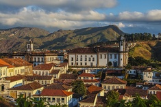
Biggest cities
Minas Gerais is the second most populous state in Brazil, with an estimated population of over 21 million inhabitants in 2020. The state's demographic density was 33.41 inhabitants per square kilometer in 2010. The central region of the state, in particular the metropolitan region of Belo Horizonte is the most populous and the one with the highest population growth in the entire state. Soon thereafter are the regions of Alto Parnaíba, Midwest, South and Triangle. The northeastern region of the state, in turn, has the smallest population contingent in the state due to the region's poverty and economic stagnation. The population of Minas Gerais was composed in 2012 by 49.2% men and 50.8% women. The fertility rate in 2012, that is, the average number of children that a woman would have on average is 1.7, just below the national average, which is 1.8. Infant mortality in the same year, in turn, was 13.2 deaths per thousand live births, also below the Brazilian average of 15.7 deaths. Finally, life expectancy at birth in Minas was around 76 years, for women this expectation is 79 years and for men it is approximately 73 years.
Below, the 20 biggest cities of Minas Gerais, according to Estimate 2019 of the Brazilian Institute of Geography and Statistics (IBGE).
| Biggest cities of Minas Gerais | |
|---|---|
| Belo Horizonte | 2,512,070 |
| Uberlândia | 691,305 |
| Contagem | 663,855 |
| Juiz de Fora | 568,873 |
| Betim | 439,340 |
| Montes Claros | 409,341 |
| Ribeirão das Neves | 334,858 |
| Uberaba | 333,783 |
| Governador Valadares | 279,885 |
| Ipatinga | 263,410 |
| Sete Lagoas | 239,639 |
| Divinópolis | 238,230 |
| Santa Luzia | 219,134 |
| Ibirté | 180,204 |
| Poços de Caldas | 167,397 |
| Patos de Minas | 152,488 |
| Pouso Alegre | 150,737 |
| Teófilo Otoni | 140,592 |
| Barbacena | 137,313 |
| Sabará | 136,344 |


Economy
Minas Gerais is the Brazilian state that has the third largest gross domestic product, which totaled R$351.38 billion at the end of 2010. Over the past few years, the Minas Gerais economy has shown practically continuous growth, interrupted only during the great recession. between 2008 and 2009. However, afterwards, the economy grew again at a faster pace than the national average. Of the Minas Gerais regions, the Metropolitan Region of Belo Horizonte concentrates 45% of the state's economic activities, and is also one of the regions with the highest growth. The capital of Minas Gerais alone has 43% of the region's economic activities, followed by the municipalities of Betim and Contagem. Following are the Triângulo Mineiro and Alto Paranaíba, the South and Southwest of Minas, Zona da Mata and Vale do Rio Doce which together account for about 40% of the mining GDP. The least developed regions are the Jequitinhonha and Mucuri valleys, which together account for 2.1% of the state's GDP.
The state, according to 2012 data, is the third largest exporter in the country, being responsible for 12.78% of the products sold abroad, behind only São Paulo (26.55%) and Rio de Janeiro (12.88 %). The state's export basket, however, is very concentrated and based on primary products, mainly iron ore (43.15%), coffee (11.29%), iron alloys (5.86%) and gold (5.15%). The total volume of exports in 2012 was approximately US$ 33 billion dollars.

The primary sector of the Minas Gerais's economy corresponded to about 8.7% of the sum of everything that was produced in the state during 2012. Of the state's cultures, coffee was the one that had the greatest participation in terms of value of state agricultural production, reaching 40% in 2011. In 2017, Minas accounted for 54.3% of the total national coffee production, being, therefore, the largest producer in the country.
The southern region of the state is the main source of coffee from Minas Gerais, where the Arabian variety is mostly grown. Sugarcane production, in turn, represents almost 20% of the value of Minas's agricultural production, followed by corn, soybeans and beans. The potato, on the other hand, has the main national producer in the state of Minas Gerais, with 32% of the total produced in the country. In Brazil, there was a total producing area of around 4 thousand hectares of strawberries. The largest producer is Minas Gerais, with approximately 1,500 hectares, cultivated in most municipalities in the extreme south of the state, in the Serra da Mantiqueira region. Regarding livestock, Minas Gerais leads the national milk production, with a production of 8.4 billion liters in 2010, which was equivalent to a quarter of the Brazilian production. The state also has an important national participation in beef, pork and chickens.
In 2018, Minas Gerais had an industrial GDP of R$142.8 billion, equivalent to 10.9% of the national industry. It employs 1,141,944 workers in the industry. The main industrial sectors are: Construction (17%), Extraction of Metallic Minerals (16.2%), Metallurgy (12.9%), Food (11.4%) and Industrial Services of Public Utility, such as Electricity and Water (11%). These 5 sectors concentrate 68.5% of the state's industry.

The activity of extraction of metallic minerals is the one that has the largest participation in the secondary mining sector, with approximately a quarter of representation in the state industry and accounts for more than forty percent of the national mineral production. 3/4 of the Minas Gerais industry, in turn, correspond to transformation activities of which the most participatory is the metallurgy sector, and, in the scope of the steel industry, the state was responsible for a third of the national production. Here are installed production units of some of the largest groups linked to the sector in the country, such as Gerdau, Usiminas and ArcelorMittal. Next, the food products sector stands out, which corresponds to 13% of the industrial activities in Minas. Then, with a practically similar participation, is the automobile sector, responsible for the production of almost a quarter of the national production of vehicles based on the presence of production units from companies such as Iveco, Fiat and Mercedes Benz. The production of cement is also noteworthy, with the state being the largest national producer, a fact that is favored by the large reserves of limestone in the territory of Minas.
Finish of the Part 2
Wow. We finished the part 2 of Minas Gerais: Marvelous Sunrises, Amazing Surprises. We also saw many things, as the part 1, with the Minas’s History. Who love Geography (as me lol) probably loved this blog. Topography, hydrography, climate, vegetation and environment, biggest cities, and economy. Now, the part 3, the last of this journey. We’ll see many components of the culture of the state, such as music, literacy, folklore, crafting, gastronomy, architecture, tourism, sports, famous people that born in Minas, and a image gallery! I think it will be the longest part, but will finish with a flourish. I’m sorry for be late. I’m going to have test week this week, and many stuff happened last week for I be late. Nothing for worry, though. The Part 3 will be really late due to the long content, which wasn’t totally previous planned. Also, I know is irrelevant, but I published three charts since the new update, and hope you like them! So, that’s the end of Part 2, and be on to the Part 3 of Minas Gerais: Beautiful Sunrises, Amazing Surprises!
So you saw my commending comment last blog, and I won't reiterate all that celebratory stuff, but again I enjoyed this impressive blog
even though I preferred the first one. Really excited for the last one, and I'm sure it'll be fascinating. Nice job MGManed Wolf:
Bush Dog:
Brazilian Tapir:
Giant Anteater:
Capybara:
Jaguar:
Sloth (random type):
Lear’s Macaw:
Brazilian three-banded armadillo:
Agouti:
Picazuro pigeon:
Golden Lion Tamarin:
And that’s amazing! I love the Brazilian Fauna. Best ever!
The first name that the current city of Uberlândia had was São Pedro de Uberabinha, a name received when it became a district of Uberaba on May 21, 1852. By State Law No. 23, of March 14, 1891, it was renamed Uberabinha , same date of installation. By State Law nº 1.128, of October 19, 1929, the city was renamed Uberlândia, a name that remains until today.
"Uberlândia" is a term composed of two terms of different origins: "uber" and "lândia":
"Uber" comes from the Latin ("fertile"), although this etymology is disputed;
"Landia" comes from the German land ("land").
Belo horizonte is trash! A bad city! I hate you! Pão de queijo is disgusting! Belo Horizonte=🤬🤬🤬🤬🤬 No #Minas4Life1!!!!1!11
I pass over all this hate you passed. BH is gorgeous, has a lot of plazas and parks, good infrastructure and life quality, and have kind people as the whole state, different of SP yeah? São Paulo is ridiculous and overestimated. You paulistas need to stop copying the cheese breads, because yours are gross, disgusting and have more eggs than cheese. You also need to stop thinking you’re amazing and everyone loves you. Don’t self-deceive 🙃
(Was supposed to be funny)
Milk is just good with NESCAU. Coffee is, meh. The first Brazilians are the natives and indigenous. You started, so you stop lol! Cookies are better!
This is great information MG! I never knew that Minas Gerais' GDP is that large so thanks :)
#Minas4Life!
Let's stop
I have no idea why but if you know please tell me :)