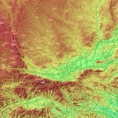
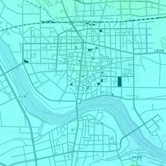
根据城区地形地图写出陕西各地市 Shaanxi cities on urban topographic map
请根据叠加的城区地形地图写出对应的陕西省地级市。
图片来源:https://zh-cn.topographic-map.com/,以opentopomap作为底图
方向均为正上北下南,所有图片比例尺一致,高度色彩根据各自图幅环境自适应调整,最蓝为最低,随海拔增加依次为蓝-绿-黄-红-白,各图色彩标尺不一致
Rate:
Last updated: March 24, 2024
You have not attempted this quiz yet.
More quiz info >>
| First submitted | March 2, 2024 |
| Times taken | 18 |
| Average score | 100.0% | Report this quiz | Report |
2:00
Enter answer here
0
/ 10 guessed
Time Used
00:00
Best Time
00:00
The quiz is paused. You have remaining.
Scoring
You scored / = %
This beats or equals
% of test takers
also scored 100%
The average score is
Your high score is
Your fastest time is
Keep scrolling down for answers and more stats ...

|

|

|

|

|

|

|

|
|

|
5 Comments
Show comments >
uoiu
+1
Level 66
Mar 2, 2024
不知道大家更喜欢这种底图还是浙江那种卫星底图
uoiu
+1
Level 66
Mar 2, 2024
这家的底图容易让人把一些密密麻麻的城区也看成乡村
Xon
+1
Level 18
Mar 24, 2024
这个好这个好
Xon
+2
Level 18
Mar 24, 2024
时间给的有点多,陕西就那么几个地级市,除了一眼西安,挨个蒙一遍还剩两分钟
uoiu
+1
Level 66
Mar 24, 2024
我说怎么正确率那么高(
New and Popular
Save Your Progress
中国地市城区图 Chinese metro areas map
Quiz series by uoiu
...
Copyright H Brothers Inc, 2008–2024
Contact Us | Go To Top | View Mobile Site