Featured Quizzes
User Quizzes
Create Quiz
Data and Charts
Badges and Games
About JetPunk
JetPunk Shop
Dark Mode
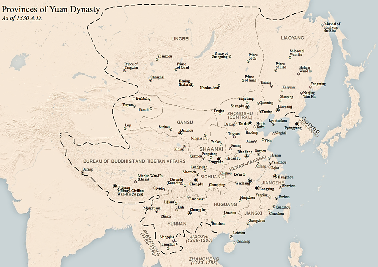
Provinces of the Yuan Dynasty in 1330 - Map Quiz
Select the correct name for each province.
Excludes provinces didn't exist in 1330.
The borders of Yuan dynasty China, as well as the borders of the Chagatai Khanate, are marked by dashed lines.
Nearby nations (the Chagatai Khanate, Japan and the Ryukyu Kingdom), nearby peoples (the Ainu and Nivkh), special provinces that existed during the 13th century (Jiaozhi, Zhancheng and Zhengmian) and other areas within Yuan dynasty China (the Central Region controlled by the Central Secretariat (Zhongshu Sheng), and the Tibetan Plateau controlled by the Bureau of Buddhist and Tibetan Affairs (Xuanzheng Yuan)) have been labelled on the map.
Based on this map.
Save time by using Keyboard Shortcuts
Rate:
Last updated: October 5, 2021
You have not attempted this quiz yet.
More quiz info >>
| First submitted | October 5, 2021 |
| Times taken | 105 |
| Average score | 54.5% | Report this quiz | Report |
2:00
0
guessed
11 remaining
The quiz is paused. You have remaining.
Scoring
You scored / = %
This beats or equals
% of test takers
also scored 100%
The average score is
Your high score is
Your fastest time is
Keep scrolling down for answers and more stats ...
Select Province
Gansu
Henan-Jiangbei
Huguang
Jiangxi
Jiangzhe
Liaoyang
Lingbei
Shaanxi
Sichuan
Yunnan
Zhengdong
This Answer is:
Angbo
+3
Level 65
Oct 5, 2021
interesting
New and Popular
Save Your Progress
Historical Subdivisions
Quiz series by MaxStickies
Copyright H Brothers Inc, 2008–2024
Contact Us | Go To Top | View Mobile Site