Featured Quizzes
User Quizzes
Create Quiz
Data and Charts
Badges and Games
About JetPunk
JetPunk Shop
Dark Mode
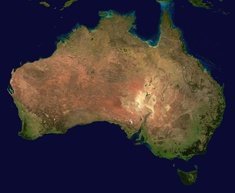
Draw all Australian State Borders on a Map
Australia has 8 states/territories, but only 7 of them are located on the mainland. Can you name every border between internal states/territories of Australia with the help of an empty map?
The borders on the map will appear after guessing them
SVG source: Australia Map by Vemaps.com
I got the idea for this quiz from plattitude
To type in an answer, just type the two bordering states (in any order).
Rate:
Last updated: December 25, 2023
You have not attempted this quiz yet.
More quiz info >>
| First submitted | December 24, 2023 |
| Times taken | 117 |
| Average score | 90.0% | Report this quiz | Report |
4:00
Enter border here
0
/ 10 guessed
Time Used
00:00
Best Time
00:00
The quiz is paused. You have remaining.
Scoring
You scored / = %
This beats or equals
% of test takers
also scored 100%
The average score is
Your high score is
Your fastest time is
Keep scrolling down for answers and more stats ...
|
|
izna
+1
Level 68
Dec 25, 2023
Inaccurate
jacoba
+1
Level 57
Dec 25, 2023
How is it inaccurate?
kuel
+2
Level 63
Jan 6, 2024
Nice quiz! 10/10 :)
plattitude
+2
Level 91
Feb 2, 2024
Nicely done! Almost forgot about the enclave ACT.
bachslunch
+2
Level 91
Mar 23, 2024
So glad you allow abbreviations — thanks!
New and Popular
Save Your Progress
Draw Borders on a Map
Quiz series by jacoba
Copyright H Brothers Inc, 2008–2024
Contact Us | Go To Top | View Mobile Site