Intro
The Canada-United States border is the longest in the world and traverses a lot of terrain in its mostly-straight course from the Atlantic to the Pacific and then from the Pacific to the Arctic Ocean. In the eastern part of the country, it follows various rivers with some straight lines in between, then winds through the Great Lakes and a couple more rivers, then in the west it becomes a straight line at the 49th parallel. This blog looks at a few random spots on the border.
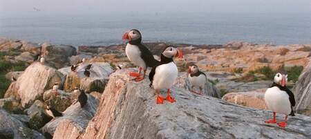
Machias Seal Island
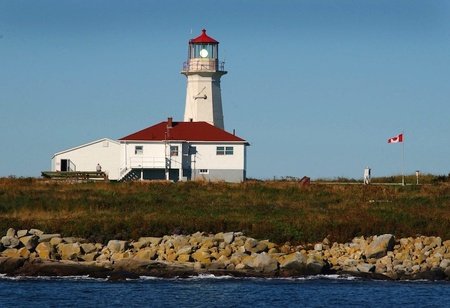
A few kilometres off the coast of Maine and New Brunswick lies a small island packed with puffins and the only manned lighthouse in Atlantic Canada. The island has been disputed between the United States and Canada since they existed, and both countries have specifically avoided applying to the International Court of Justice in fear of losing the island or the adjoining lobster fishing area.
The Canadian flag can be seen on the right
The Canadian claim to the island is based on the vague wording of a
1621 land grant which, depending on how you read it, could, according the the later 1783 treaty, put it within either the United States or Canada. The most recent injury of the border war was Maine lobsterman Patrick Feeney, who got his thumb ripped off while fighting with a Canadian. Sometimes Maine fishermen even asked the Canadian lighthouse keepers for rent.
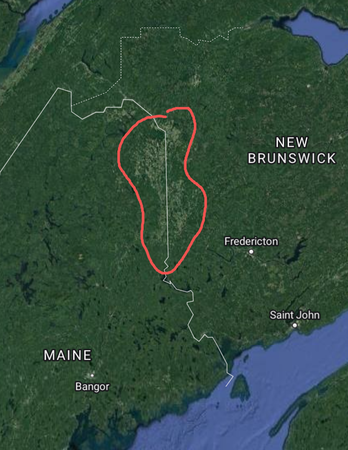
Saint John River Valley
The Saint John River Valley is bisected north-south in half by the border - which at this spot is a straight line. The local population of the valley, to this day mostly francophones, had very little say in where the border was drawn. They did, however, almost
plunge the United States into a third war with Britain in the 1830s, after the King of the Netherlands had unsuccessfully tried to draw a more practical boundary along natural boundaries such as rivers. The animosity between the American lumberjacks and the Canadians was the original reason that the area didn't just become part of Canada in the first place.
The farmland of the valley is split by a straight line.
Canusa Street
On the line between Quebec and Vermont, in a straight line, runs Canusa Street. Driving west, you would be in Canada, while driving east, you would be in the US of A. When the border used to be less strict, specifically before September 11, 2001, residents and others would have no problem crossing the street to fetch a lost basketball or visiting their neighbors. However, since then, it is required to report to the official border crossing to cross. Oh, and the street's name comes from mixing "Canada" with "USA". From reading the Wikipedia page on border portmanteaus, it seems we mostly do this in North America.
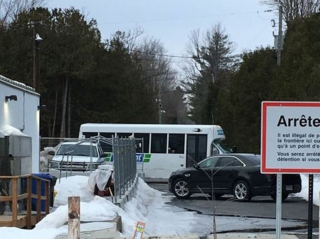
Roxham Road
In an isolated northern New York town, thousands of people are dropped off each year on their way to Canada. The RCMP dutifully look after each refugee, guiding them on their path toward Canadian citizenship. This road from New York to Quebec has no border but a dead end on both sides, with a small gap in between. Many refugees will then take a
taxi to the unofficial border crossing. The refugees are largely people who fly into New York from Latin America for the sole purpose of coming to Canada.
A bus dropping off asylum seekers
Lake of the Woods
The Lake of the Woods is another geographic oddity of the border. Because of how the borders were drawn, the United States owns a peninsula called the northwest angle whose only land access is through the province of Manitoba. On it are about 120 people, the only residents of the contiguous states to live north of the 49th parallel (although it arguably isn't contiguous at all because of the lake).
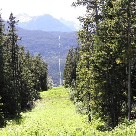
The Long Straight Line
For the entire length of Manitoba, Saskatchewan, Alberta, and B.C., the border is a straight line at the 49th parallel. It crosses a lot of prairie, some forest and mountains, and a very, very long distance.
What the border looks like in the mountains
Ever since the 1800s, the two governments have each kept the 10 feet on their side of the border free of trees, meaning there is a 20-foot wide "Slash" through the trees the whole way along (except for the places where there aren't trees, like most of the prairies). The purpose of this is to inform people they are at the border.
Point Roberts
Yet another quirk of the straight line, this area is quite small and very close to the Canadian city of Vancouver despite being in the United States. It is disconnected from the US, and made headlines during the pandemic for being almost entirely inaccessible, due to the closed border.
Alaska
Alaska has an almost tropical climate compared to the Canadian territories, and in addition to that, it has oil! These factors combine to make the population of Alaska almost 8 times that of the territories despite having less land area and similar latitudes. The border in Alaska includes a straight line, but also includes, in the southern end, what looks to be a geographically inspired border. Well, I hate to say it, but no, the border does not follow mountains, rivers, or any of the other geography it lies on. It's just a line that stays exactly 56 km from the shore. This may sound impractical, but the area is so sparsely populated that it makes very little difference.
All of Alaska looks like this
Some opinions
I realize, this is a bit political, but I personally think that the border is largely unnecessary and both nations would be better served by its removal. Whether by car or plane, the border adds a lot of waiting to any cross-border travel. While I understand the reasoning behind a lot of hard borders, this one just doesn't make sense. Canada and the United States are so similar on so many levels that we could easily merge into one nation. The Schengen area agreement in Europe works very well (I think) between nations that have less in common than Canada and the States. While an open border might cause some problems, especially in gun-intolerant Canada, it's not like the border is stopping everything anyways; it's mostly just annoying for the people who live near it. I guess us Canadians like to try to prove to ourselves that we're not just another subsidiary to the US.
Are you going to write some other blogs about other borders around the world ?