Five Islands of East Asia
First published: Saturday July 8th, 2023
Report this blog
Introduction
Here we go again !
I'm beginning to feel like a proverbial bad penny, I keep turning up and boring you all with tales of some remote island that no-ones ever heard of, well apart from the people living there obviously.
I'd like to start with a thank you to QuizzerBros for their excellent blog, made with my blessing, about Five Islands of Tasmania. I hadn't intended to write a stand alone blog about Tazzy so it is a great edition to the RUB. I will probably do Oz and NZ in one blog next, it leads onto South, Central and North America nicely. I had intended to finish in the north anyway, mainly to just redress the USA centric nature of the site. (Nothing wrong with that, Quizmaster, just makes a change for you guys over the pond to be at the end rather than the beginning.)
So enough waffling on from me, let's look at where we are this time.

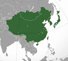
As you can see from the above map, the East Asia region comprises of China, Taiwan, North and South Korea, Japan, and Mongolia. As I mentioned at the end of my last edition to this series, Mongolia being land-locked and partly desert, only has a few small islands on inland lakes for which there is little or no information.
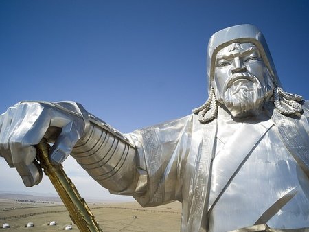
So, sorry Mongolia, I'm going to have to skip past you this time, perhaps if I do a blog on mega statues you'll be in with a chance with your Genghis Khan on Horseback statue. Now we have discounted the world's most sparsely populated sovereign state, we shall mosey along to our first island. Orf we jolly well go to the People's Republic of China...
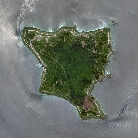
Naozhou Island (China)
Naozhou is a small rocky island near to the south-eastern tip of the larger Donghai Island in the South China Sea. It is part of Guangdong Province.
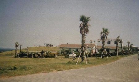
The island is known as a miniature Hainan, with just one of everything. One town, one ferry, one beach, one.....well, you get the idea I'm sure.
From 1899 until 1945, Naozhou was part of a French leased territory. The islands lighthouse, built during their occupation still stands to this day and is a historic site now.
Prior to the French occupancy the islands history is almost non-existant, however it is known that the island was evacuated during the Qing Dynasty in around 1650. Troops were stationed on the island as protection against pirates.
There is only one beach, but there are many small fishing communities scattered around the coast, some also have aquaculture ponds in which they grow shrimp.
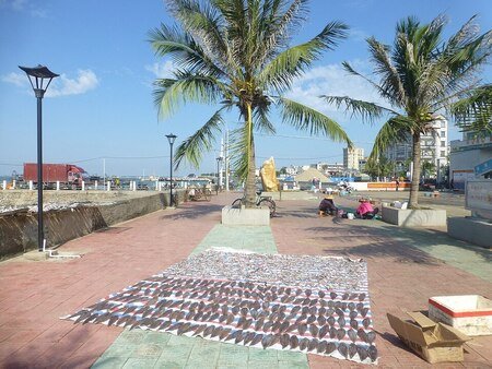
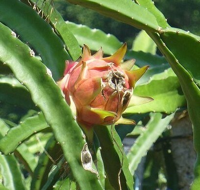
The interior of the island is mainly agricultural land, the main crops being bananas and dragon fruit, along with a green plum called jujube.
The only other significant industry is tourism.
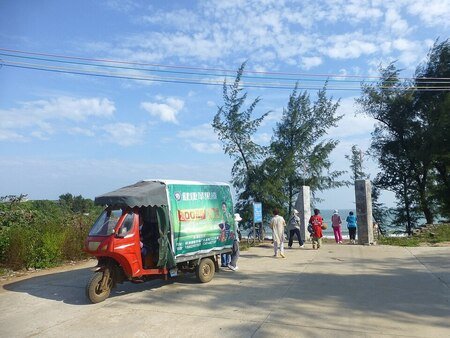
The island is more or less car free, despite having a car ferry service. The local taxis are three wheeled vehicles similar to the Tuk-Tuks that are found throughout Asia.
One of the major attractions on the island is known as Sea Turtle City.
Here, tourists can feed sea turtles by hand with thinly sliced melon. The turtles are so used to this that they will approach any human in the hope of food. It is not clear where the attraction obtained the turtles or if any are released into the wild.
Getting to the island is easy, provided you are already on Donghai Island, which incidentally is connected to mainland China via a road bridge. A ferry departs from the town of Dongnan's harbour every hour between around 0700 and 1700 hours. If you wish to stay on the island there are some small hotels and restaurants, however most of the island can be seen on a day trip.
The only film I can find is of the Sea Turtles feeding.
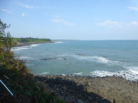
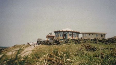
Green Island (Taiwan)
Green Island is situated about 33km or 21 miles off the east coast of Taiwan in the Pacific Ocean. It has only been known as Green Island relatively recently having been changed by the ROC government in 1949. It was previously called Samasana, it's original Amis name. Amis were the original inhabitants and are an aboriginal Taiwanese race.
The island has seen a few shipwrecks over the years. In 1864, a British ship, the Susan Douglas was wrecked during a storm. The captain sailed to the mainland in a local boat and returned to collect his crew.
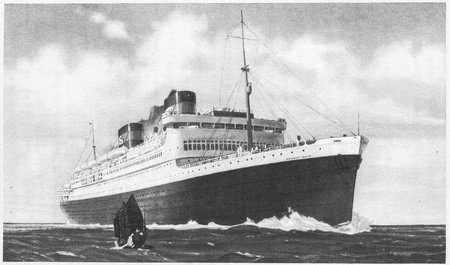
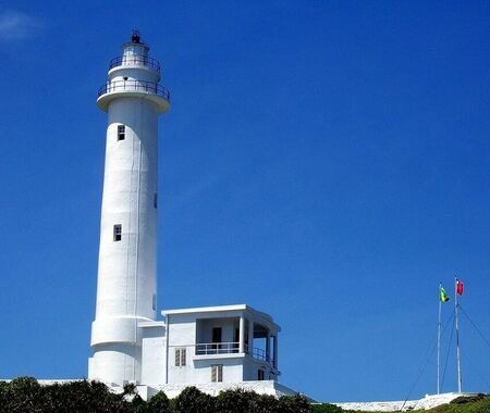
Later in 1937, a cruise ship, the SS President Hoover , ran aground during a typhoon. All of it's passengers and crew survived and were housed on the island until rescued over the following weeks. A year later the locals on the island began construction of a lighthouse financed by US citizens via the American Red Cross.
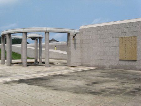
The island is a tourist attraction these days, however, it used to be a penal colony during the era known as "The White Terror", a period of martial law in Taiwan that ended as recently as 1992. Some of the former prisoners went on to establish the political party currently running Taiwan's government. A prison still stands on the island and until recently housed some of Taiwan's most dangerous criminals.
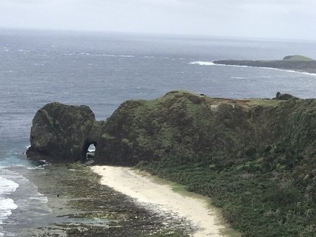
Tourists to the island can expect mountain and coastal walks, including the "Miniature Great Wall" and ecology parks, as well as memorials to the islands former status as a penal colony. Sleeping Beauty Rock is a large outcrop that resembles a "Sleeping Woman" Obviously!
Getting to the island is by air from Taitung City on the "mainland" or by ferry from Fugang Fishery Harbour in the same city.
This YouTube video is a short report on things to see and do on the island.
Yanggak Island (North Korea)
Now, obviously with the secretive nature of the Democratic People's Republic of Korea, this item will probably be a little shorter than others, we shall see what I can dig up. (Not literally, Respected Comrade Kim Jong Un) Not that he'll be reading this...although who knows? Perhaps the Quizmaster or Stewart can confirm if the North Korean leader is a member of JetPunk or not ?
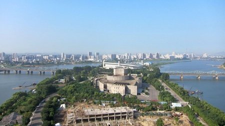
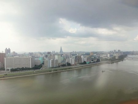
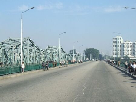
Anyway, enough padding. This island is located just south of the centre of the capital Pyongyang in the Taedong River.
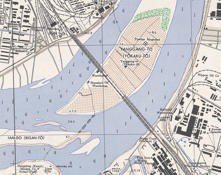
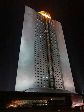
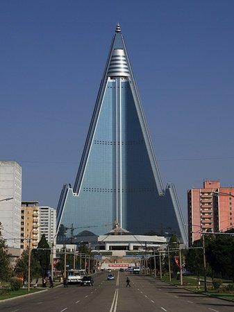
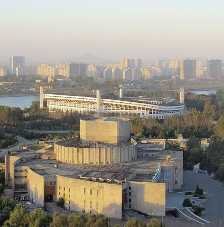
The island is split into unequal parts by the imaginatively named Yanggak Bridge. The southern section contains a 30,000 seat multi-purpose stadium that was built in 1989. The northern part contains the Yanggakdo International Hotel, the second tallest building in North Korea after the iconic arrowhead shaped Ryugyong Hotel.
There was originally a nine hole golf course next to the hotel, but this was demolished in 2011 to make way for a Chinese funded health complex. Also on the island is the Pyongyang International Cinema Hall that hosts the Pyongyang International Film Festival.
The hotel is usually used to host visitors from other countries on official tours and boasts facilities similar to most luxury western hotels.
On the 2nd of January in 2016, a visiting American student, Otto Warmbier was arrested after stealing a propaganda poster from a restricted staff area of the hotel. He was sentenced to 15 years imprisonment with hard-labour but was released after 17 months after suffering severe brain damage. He returned to the States in June 2017, but died less than a week later.
Getting to the island is easy, as long as you are on a official tour (the only ones available) you will already be staying in the hotel on the island anyway. Just don't be tempted to collect any "souvenirs" from the walls of the hotel.
Amongst the many YouTube videos about the DPRK, there are many that are quite, how do I put this?, egocentric. More about the YouTuber than the destination, however here's a short clip taken on the edge of the island in 2013. (Wow, 10 years ago).
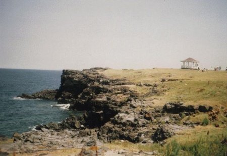
Marado (South Korea)
Marado or Mara Island (remember do means island in Korean, where you paying attention ?) marks the southernmost point of South Korea. It is located in the East China Sea just 8km or 5 mile south of Jeju, South Korea's largest island.
It is only small and the entire coastline can be walked in as little as 90 minutes.
Marado was uninhabited until around 1880, when a poor peasant woman with her two brothers moved to the island following their fathers death. He apparently had told of the island and the farmland upon it on his death bed. They were only joined 10 years later by some stranded Japanese fisherman from another island.
However, documents from Jeju tell a different story about a man that had spent all his fortune and was allowed to live on the island in 1883. The true story may never be known.
Nowadays there are around 90 inhabitants, but the island has a reputation of being home to "strong women and docile men", whatever that means. This number is boosted by up to 700 tourist each day.
Attractions on the island include it's rocky coastline and cliffs, a temple, and a rock known as Janggun Rock, that the locals believe to be their guardian and as such is regarded as sacred.

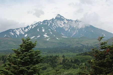
Rishiri Island (Japan)
There were many islands I could have chosen for Japan, in fact I could have done a "Twenty Islands of Japan" blog and still got nowhere near to the 14,125 islands in the Japanese archipelago. But I had to choose one, so here we are on Rishiri Island. This volcanic island is located in the Sea of Japan off the coast of Hokkaido, Japan's second largest island.
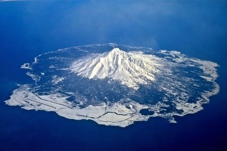
The island was formed by the now extinct volcano, Mount Rishiri, and is part of a National Park, the Rishiri-Rebun-Sarobetsu National Park. Rebun is also an island whereas the Sarobetsu plain is on the main island of Hokkaido.
The main industries of the island are tourism and fishing. There is a permanent population of just over 5,000 people, mainly concentrated in the two towns of Oshidomari and Kutsugata
The name of the island derives from the Ainu language and means "Island with a high peak".
It is thought that the last eruption of the volcano was around 5000BC.
Most of the inhabitants live in coastal communities and are connected by two bus routes. One drives clockwise around the island and the other anti-clockwise. Both routes serve the same stops !
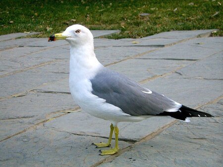
Rishiri Island has been recognised as an Important Bird Area because of it's populations of Black-Tailed Gulls and Japanese Robins.

In 1848, Japan's first native English speaking tutor arrived to teach English by landing on Rishiri illegally. Ranald MacDonald (yep, that was his name) pretended to be shipwrecked despite a strict policy of isolationism by the Japanese government of the time. Normally this would have meant death or at the very least imprisonment to any foreigner landing on Japanese soil, however Ranald was sent to Nagasaki where he began to educate several samurai. One of his students became the main translator when Japan was invited to sign a declaration opening the nation up to the west.
The island can be reached by ferry from the island of Rebun, and from Hokkaido via the ports of the towns of Otaru and Wakkanai. There is an airport with flights from Wakkanai.
This Japan Guide web page has photos and information about Rishiri island.
Summary
That's Asia done then, I think....
Where next ? Do I head across the Pacific to North America and the wilds of Canada, or do I head south into Oceania? Decisions, decisions.
I think I shall follow QuizzerBros into part of Oceania. I shall start in Papua New Guinea, and then Australia and New Zealand. The rest of Oceania I intend to cover later with blogs about each ocean, for example "Five Islands of the Atlantic" but one for each body of water. But that's later, much later.
So the next islands blog will be entitled "Five Islands of the Antipodes". Now I know that technically Antipodes means any diametrically opposite point on Earth, however in the UK we occasionally talk of Oz and NZ as our antipodes. Whether that is actually correct or not, I don't know, but I'm going with it anyway. My blog, my choice.
Obviously, as these things usually go, there may be another completely unrelated blog before that, I haven't decided yet.
On a final note for now, I'd once again like to thank QuizzerBros (link in the introduction) for making the "Five Islands of Tasmania" blog, it has given me the Kick up the Khyber I needed to get on with my writing and blogging. Little bit of Rhyming Slang there from the last blog, See what I did there ? Check it out here. In case you're procrastinating I'll explain, "Kick up the Khyber" = "Kick up the Khyber Pass" = "Kick up the Ass".
On that note I bid you farewell for now.
About Mongolia. I tried to look for islands now, and found one — Ak-Bash on the lake Khav-Us-Nuur. But, as you said, there is little more than no information about it (no photos, no facts, only the size of the island and the mention of an article about the lake), only based on the maps can we say that it divides the lake into two parts, connected by channels, and sometimes connects to land when the lake dries up. But I think adding this island is pointless, only just for show this country.