
Angola Explained
Last updated: Monday February 21st, 2022
Report this blog
Navigation
Angola
| Quick Facts | |
|---|---|
| Capital | Luanda |
| Other Cities | N'dalatando, Huambo |
| Population | 33 Million |
| Area (in square miles) | 481,400 |
| Official Language(s) | Portuguese | Bordering nations | Republic of Congo |
| D.R. Congo | |
| Zambia | |
| Namibia | |
| Ethnic Groups | |
| Ethnic Group | Percent (%) |
| Ovimbundu (Southern Mbundu) | 37 |
| Ambundu (Mbundu) | 25 |
| Kongo | 13 |
| Other | 25 |
Geography
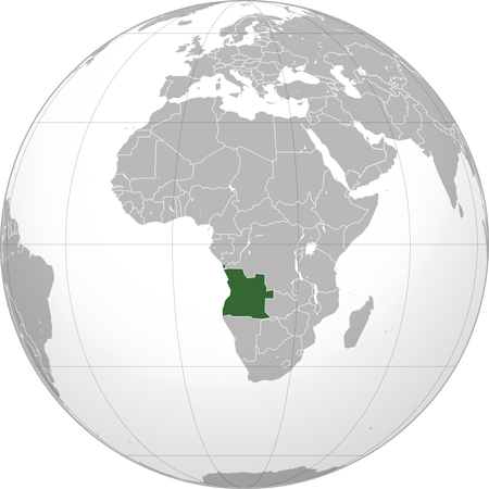
Angola is located in Middle Africa, with the Atlantic Ocean to its west, Namibia to its south, Zambia to its east, and the D.R. Congo to its north. However, it borders another country and for this, we need to take a look at this map:

As you can see, there is another part of Angola, called Cabinda (I'll get back to this in like a minute). Cabinda borders both the D.R. Congo (which we already said before) and the Republic of Congo. Angola has many geographical features. In the south is the Kalahari Desert, which, if we take a look at this screenshot of Google Maps, is really big.:

As you can see, it covers the entirety of Namibia and goes a little into Angola. If we go into a little more detail, this is what we see:

Or if we go to satellite mode, this:

This screenshot also brings us to our next point. Take a close look at the northern part of Angola. It seems really dark green, right? This means that this region is a rainforest. In fact, the D.R. Congo (which is north of Angola) is almost 100% rainforest, and a lot of the rainforest spills into Angola. Although there is deforestation, it is relatively low.
History
Angola was where the Kingdom of Kongo first popped up. The Kingdom of Kongo later conquered territories in what is now the D R Congo, and the similar name is no coincidence. The Kongo was a thriving kingdom that was founded in the 1300s and would last for the next 500 or so years. Of course, the Portuguese just had to come over and ruin everything. Portugal colonized Angola in the 1600s. But this story also has a dark side. The Portuguese imprisoned the locals, and then put them on crowded ships to Brazil to work on sugarcane farms. Brazil would go on to win independence in 1820, but Angola would remain a colony for many years.
While Angola remained a colony, so did Cabinda. Cabinda isn't actually connected to Angola, but when Angola got independence in the next section, Cabinda joined it.
In the 1960s, Angola found an opportunity to gain independence. At this point in time, European countries were giving independence to their overseas territories. However, Portugal wouldn't budge, insisting that these were overseas departments, sort of like how French Guiana is an overseas department of France. But unlike French Guiana or many other overseas territories, Angola wanted independence. So, they took action. The National Front for the Liberation of Angola (FNLA) recruited refugees from the D.R. Congo. However, something happened, not in Angola, but in Portugal, that would change Angola's future: Portugal had a revolution. The new government was Marxist, and it started giving independence to its overseas colonies like Angola, Mozambique, and Guinea-Bissau.
When Angola gained independence, things went down. Long story short, Angola had a civil war. On one side was the democratic side (UNITA), backed by the US and mainly South Africa. On the other side were the communists (MPLA), aided by the Soviet Union, and mainly Cuba. South Africa gained what is now Namibia. After a long war, the two sides agreed to an election. The MPLA won the election, and the UNITA returned to war. Soon the two sides reached another agreement. Now, the two are just political parties in Angola.
Thanks for reading!