Antigua and Barbuda Explained
Last updated: Monday February 21st, 2022
Report this blog
Navigation
Antigua and Barbuda


| Quick Facts | |
|---|---|
| Capital | St. John's |
| Other Cities | All Saints, Liberta |
| Population | 97,929 |
| Area (in miles²) | 171 |
| Area (in km²) | 252 |
| Official Language | English | Bordering nations | None |
| Ethnic Groups | |
| Ethnic Group | Percent (%) |
| African (Black) | 91% |
| Multiracial | 4.4% |
| European (White) | 1.7% |
| Other | 2.9% |
Geography
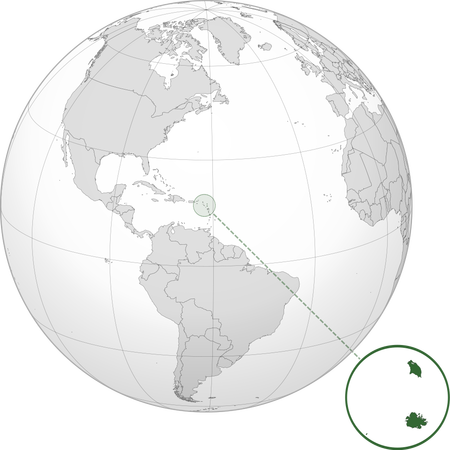
Antigua and Barbuda are a chain of islands in the Caribbean. Here is a map:

Barbuda is the one on the north and Antigua is the one on the south. Antigua has the eight most populous towns in the country. Antigua and Barbuda might be one of the many nations that suffer a lot from global warming. Like many other island nations, Antigua and Barbuda face an uncertain future where there is a possibility that the island will be washed away. Plus, hurricanes occasionally pass by the islands, and in this nation where 80% of the money is made from tourism, hurricanes (and COVID-19, now that I think about it) have really hurt the economy.
History
Native Americans were the first ones to set foot on Antigua and Barbuda, and around 3100 BCE, the first settlements were created. In the early 1400s, the Europeans found out that they weren't the only ones living in the world. And with that, Spain, the UK, France, and other nations were setting up colonies in the Americas. In Antigua and Barbuda, the Spanish tried and failed to invade. However, the Spanish spread viruses like smallpox. Smallpox was a disease that was unknown to Europeans, and most of them were immune to smallpox and many other diseases since they were living side to side with cows and pigs and sheep that carried diseases. Soon, the English came along, and as they always did, as long as they thought they were there first, it was theirs. The English grouped Antigua and Barbuda with many other Caribbean islands into the Leeward Islands.

Soon, they began forcing Africans to come to the islands to work as slaves on sugarcane and tobacco farms. But the English and Spanish weren't the only ones who wanted the islands. The French tried (and failed) at capturing the islands in 1666. Soon, the slaves, who were tired of the conditions they had to live through, launched two revolts. A third planned revolt was discovered, and the leaders were executed by the British. Thankfully, the British banned slavery in 1833. In 1842 and 1847, the islands suffered two natural disasters: first, an earthquake, and second, a hurricane.
1958, Antigua and Barbuda, along with many other countries formed the West Indies Federation, similar to how Ontario, Nova Scotia, Quebec, and others formed Canada. Here is a map of the West Indies Federation:

As you can see, the federation includes the whole of the Leeward Islands as well as many more. This federation was short-lasted, and it was disbanded in 1962. Five years later, Antigua and Barbuda gained independence. The first few decades were pretty rough. There were scandals and hurricanes. In 2017, almost all of Barbuda was devastated by hurricanes, and people were evacuated to Antigua.
Thanks for reading!
(Also, are you on a phone or computer)
I use Windows and iOS, which both work fine for me, yeah.
I might fix it if I can find the files.
Thanks though!