Brazilian National Parks - Pictures and Info! #Part 1
First published: Saturday April 10th, 2021
Report this blog
- What is a national park?
- Alto Cariri National Park
- Amazônia National Park
- Anavilhanas National Park
- Aparados da Serra National Park
- Araguaia National Park
- Araucárias National Park
- Boa Nova National Park
- Boqueirão da Onça National Park
- Brasília National Park
- Cabo Orange National Park
- Campos Amazônicos National Park
- Campos Ferruginosos National Park
- Campos Gerais National Park
- Caparaó National Park
- Final Note (not the name of a park!). This is important, so read it please.
What is a national park?
A national park is a park in use for conservation purposes, created and protected by national governments. Often it is a reserve of natural, semi-natural, or developed land that a sovereign state declares or owns. Although individual nations designate their own national parks differently, there is a common idea: the conservation of 'wild nature' for posterity and as a symbol of national pride.

Brazil currently has 73 national parks, one of the categories of conservation units for integral protection of nature defined in the Law of the National System of Nature Conservation Units, placed in category II by IUCN. They are administered by the Chico Mendes Institute for Biodiversity Conservation (ICMBio), an autarchy linked to the Ministry of the Environment created in 2007. Its basic objective is the preservation of natural ecosystems of great ecological relevance and scenic beauty, enabling the realization of scientific and the development of environmental education and interpretation, recreation in contact with nature and ecological tourism.
Now, after this “class of Brazilian Geography”, let’s start of see the NPs!
Alto Cariri National Park

The Alto Cariri National Park is a Brazilian national park, located in Guaratinga, Bahia, and created on June 11, 2010. It has about 19,264 hectares, protecting remnants of the Atlantic Forest of Bahia. Together with the Alto Cariri State Park and Mata dos Muriquis Wildlife Refuge, both in Minas Gerais, it forms one of the largest continuous stretches of southwest Bahia and the far northeast of Minas Gerais. It is the last place in Bahia where the muriqui-do-norte still live.
The park is in the Atlantic Forest biome. The eastern side of the rugged Cariri massif is moist and dominated by montane rainforest. Further west it is drier and semi-deciduous forest gradually becomes dominant. In the northern portion of the Cariri massif the forests meet the deciduous forest of the Jequitinhonha depression. At the tops of the tallest and steepest hills there are stony fields with rock outcroppings, holding many species of bromeliads, orchids, cactuses and ferns. There are 35 species of amphibians, of which nine are endemic and four are new to science.

Amazônia National Park
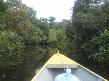
The National Park of the Amazon is located in the municipalities of Itaituba, Aveiro and Maués in the Southwest region of the state of Pará and Southeast of the state of Amazonas, Brazil. It has an area of 1,084,895.62 hectares. It is managed by the Chico Mendes Institute for Biodiversity Conservation - ICMBio.

The park lies on either side of the Tapajós River. The habitat is dense lowland rain forest and there are areas of white-sand grasslands beside the upper reaches of the Tapajós. This river rises in the Precambrian crystalline shields area of ancient igneous rock and carries little sediment. Except for about 2% of more open forest, the whole park consists of dense humid tropical forest. The larger trees reach a height of about 50 m, and the light filtering through the canopy is sufficient to produce a biodiverse understorey of vines, lichens, mosses and orchids. Many of the mammals in the park are nocturnal, and some such as the giant otter, Amazonian manatee and giant anteater are endangered. There are also large numbers of reptiles, fish and other aquatic creatures.

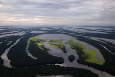
Anavilhanas National Park
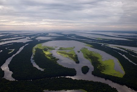
The Anavilhanas National Park is a Brazilian conservation unit for integral protection of nature located in the state of Amazonas, with territory distributed by the municipalities of Manaus, Iranduba and Novo Airão. Created in 1981, its purpose is to preserve the Anavilhanas river archipelago as well as its diverse forest formations, stimulate the production of knowledge through scientific research and promote the appreciation of the importance of the National Park for conservation through environmental education and sustainable tourism, seeking to harmonize the relations between the surrounding communities and the Unit with actions with sustainable bases.
The area of the unit is in the public domain. Visiting the unit is permitted. In some areas, visitation requires authorization to enter and stay; scientific research depends on authorization from the responsible agency (which in this case is ICMBio). Hunting, fishing (subsistence fishing by surrounding communities tolerated), logging, mining are prohibited. Changes to their ecosystems are not allowed (with some exceptions). Despite its 400 islands, Anavilhanas is not the largest river archipelago in the world. The largest river archipelago in the world is Mariuá, in Barcelos (AM), with approximately 700 islands.
Aparados da Serra National Park
The Aparados da Serra National Park is a Brazilian conservation unit for integral protection of nature located in the Serra Geral, encapsulating the gorges in the natural boundary between the states of Rio Grande do Sul and Santa Catarina. The basic objective of the park is to preserve the Atlantic Forest ecosystems, the araucaria forests and the gaucho pampa, which are of great scenic beauty, thus enabling scientific research and the development of environmental education and interpretation activities, as well as recreational activities in contact with nature and ecological tourism.

Inserted in the natural region commonly called Aparados da Serra, the park has 13 141.05 ha of area, bordering both the south and the north to the Serra Geral National Park, which is also managed by ICMBio. The climate is temperate, with an average annual temperature of 16°C, with the warmest month being January and the coldest being June and July. The average annual accumulated precipitation varies between 1500 and 2250mm.

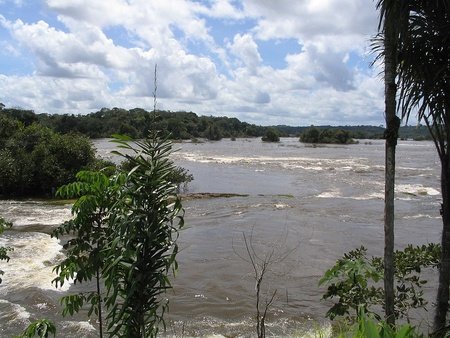
Araguaia National Park

The Araguaia National Park was created during the administration of President Juscelino Kubitschek de Oliveira, on December 31, 1959, in northern Goiás, currently Tocantins. Initially, the Araguaia National Park occupied the entire area of Bananal Island, about 2 million hectares. Currently, after two changes in its limits, the National Park occupies an area equivalent to about 562 thousand hectares. It is located in the northern third of Bananal Island, southwest of the State of Tocantins, covering part of the municipalities of Pium and Lagoa da Confusão.
The Araguaia National Park is located on a transition strip between the Amazon Forest, Cerrado and Pantanal, it consists of several species of fauna, present in these three biomes, in addition to a very diverse vegetation cover, presenting several natural scenarios of rare beauty. This conservation unit must provide not only the reception of tourists and visitors, but also the conservation of the high rate of biological diversity present and guarantee the rights of the indigenous populations residing in its interior.

Araucárias National Park
The Araucárias National Park is a Brazilian conservation unit with integral protection for nature located in the municipalities of Passos Maia and Ponte Serrada in Santa Catarina. Its main objective is to preserve the remnants of Mixed Ombrophilous Forest in the region, in order to create conditions for carrying out scientific research and the development of activities of environmental education, recreation in contact with nature and ecological tourism.

The park area comprises 12,841 ha of araucaria forests. These, with a well-preserved structure, have rich and diversified forests under the crowns of the pines, which give continuous shape to their upper stratum. Along with the beautiful landscapes and rivers of the park can be found specimens of trees with trunks over 3 meters in diameter.

Boa Nova National Park

The Boa Nova National Park is a Brazilian national park located in Bahia, between the municipalities of Boa Nova, Dário Meira, and Manoel Vitorino. Created to protect and regenerate the transition vegetation between Caatinga and Atlantic Forest, also known as Mata de Cipó. The region has been visited by bird watchers since the 1990s. The park is the habitat of the gravatazeiro, an endangered bird, endemic to the region.
The park has an area of 12,065.31 hectares. The terrain is rugged with altitudes from 440 to 1,111 meters above sea level. The park has an area of 12,065.31 hectares. The terrain is rugged with altitudes from 440 to 1,111 meters above sea level. The park is in the Atlantic Forest biome. The average annual rainfall is 1,300 mm. Temperatures vary from 14 to 26 ° C with an average of 23 ° C. Vegetation includes caatinga, semi-deciduous submontane forest, montane rainforest and semi-deciduous lowland forest. The region is known for the countless species of birds, with 437 recorded so far, which attract many foreign observers. Endemic bird species include the threatened or endangered slender antbird, Bahia spinetail and Bahia tyrannulet.
Boqueirão da Onça National Park
Considered as one of the priority areas for the conservation of the Caatinga, the Boqueirão da Onça region corresponds to one of the largest and most conserved remnants of the biome, representing an important shelter and breeding area for several species of fauna and flora in the region. It constitutes an important refuge for large mammals at the top of the chain, such as puma and spotted jaguar. The region is also home to an enormous diversity of birds, including the critically endangered Lear's Macaw; the red-necked hummingbird; the northeastern goldfinch; the jacucaca; the arapaçu-do-northeast; the caatinga-tipped beak; the arapaçu-hummingbird; and joão-xiquexique, species endemic to the region.
Brasília National Park
The Brasília National Park, also known by the nickname of Água Mineral, is a Brazilian conservation unit with integral protection to nature located in the northwest of the Federal District. It is located about ten kilometers from the center of the Plano Piloto, in Brasília. It is one of the most visited parks in Brazil, and the largest park in an urbanized area in the world. The creation of the park is directly related to the construction of Brasília. The main attraction of the park are the pools formed from the water wells, which emerged on the banks of the Camp Stream due to the sand extraction done before the creation of Brasília. The park also has two indoor trails: Capivara, lasting about twenty minutes, and Cristal Água, lasting about two hours.
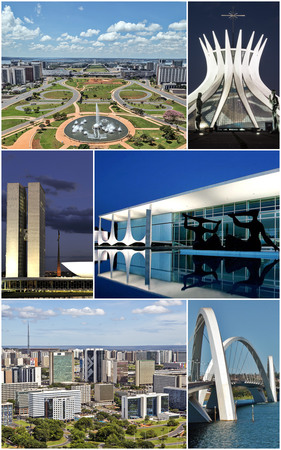
It has a very rich fauna. In 2001, there were numerous mammals threatened with extinction, such as the maned wolf, the pampas deer, the giant anteater and the giant armadillo. Groups of capuchin monkeys frequent the pool area, where they consume processed foods brought by visitors, causing health and behavioral problems for the animals. It has surface and subsurface waters, which are abundant and of high quality. The watercourses present there form two sub-basins: the largest one, the Torto sub-basin, which occupies two thirds of the park; and the Bananal sub-basin, which occupies the remaining contingent. In the park, there is the Santa Maria Dam, responsible for providing 29% of the supply of the Federal District. In 2020, it had an estimated useful volume between 45.5 million and 61.31 million cubic meters of water. The cerrado (savanna) is predominant. The vegetation around the springs and streams is of the cerrado type, which consists of gallery forests. These areas were declared natural reserves by UNESCO.

Cabo Orange National Park
The Cabo Orange National Park is a Brazilian conservation unit for integral protection of nature located in the northern region of the state of Amapá, with territory distributed by the municipalities of Oiapoque and Calçoene, next to the border with French Guyana. The park forms, together with the Tumucumaque Mountains, Monte Roraima, Pico da Neblina and Serra do Divisor national parks, the set of National Parks bordering the Brazilian Amazon. The Cabo Orange Park covers an area of 657 327 hectares and is currently managed by the Chico Mendes Institute for Biodiversity Conservation (ICMBio).
Currently, the park is undergoing a tourist viability assessment process, with community or sustainable tourism as the basis for the experiments. It does not have a planned infrastructure for tourism, but visitation is not prohibited, and to visit this area an authorization issued by the Park's management is necessary. The municipality of Oiapoque has a relative structure for receiving tourism with hotels, restaurants and various leisure activities, however, the municipality of Calçoene is lacking in these structures. The best time to visit this unit and the surrounding region is from August to December, a period when there is less rain and the roads are good for vehicular circulation. In addition to observing the mangrove vegetation, lowland fields with their buritizais and animals, it is interesting to learn a little about the simple life of the few residents of Vila Velha do Cassiporé and Vila de Cunani. They are traditional communities in which their residents live off fishing and small subsistence farming or livestock activities. It is also possible to meet water birds such as Guarás, Spoons, Herons, and, hopefully, maybe even the Flamingo-American visiting the far north of the Park. These species usually appear in the mud region in the area shortly after the tide goes out and provide a unique spectacle in the Amazon region. This moment can also be conducive to enter the mangrove or visit a dormitory of parrots on an island in the Oiapoque River outside the Park.
Campos Amazônicos National Park
The Campos Amazônicos National Park is a National park in the states of Rondônia, Amazonas and Mato Grosso. It covers parts of the municipalities of Novo Aripuanã (66.69%), Manicoré (14.73%) and Humaitá (5.01%) in Amazonas, Machadinho d'Oeste (12.91%) in Rondônia and Colniza (0.38%) in Mato Grosso. It has an area of 961,317.77 hectares. The park lies to the south of the Trans-Amazonian Highway (BR-230) in Amazonas. It is bordered to the south by the Tucumã State Park in Mato Grosso and the Manicoré State Forest and Guariba Extractive Reserve in Amazonas.
Campos Ferruginosos National Park
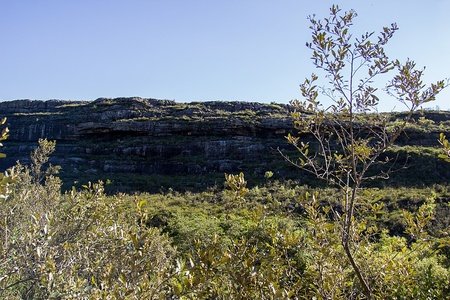
The Campos Ferruginosos National Park is an integral protection conservation unit created by the Presidential Decree of June 5, 2017. It is located between the cities of Canaã dos Carajás and Parauapebas, in southeastern Pará. The park is formed mostly by portions of land from the National Forest of Carajás - Flona Carajás, in good condition, and the rest by areas in different stages of conservation, including remnants of native vegetation and pasture environments, the latter targets of a major reforestation project.
The creation of this park aimed to protect the biological diversity of the mountains, as well as to guarantee the continuity of ecosystem services, to guarantee the protection of the speleological patrimony of iron formation, of the vegetation of ferruginous rupestrian fields, contributing to the environmental stability of the region and contributing to the development of recreational activities in contact with nature and ecological tourism.
Campos Gerais National Park

The Campos Gerais National Park is a Brazilian conservation unit, located in the Campos Gerais region in the central-eastern portion of the State of Paraná. The park has approximately 21,300 hectares of area, covering the municipalities of Carambeí, Castro and Ponta Grossa. It was created by the federal decree of March 26, 2006 with the objective of preserving the natural environments that exist there, with emphasis on the remnants of mixed ombrophilous forest and southern fields, carrying out scientific research and developing environmental education and ecological tourism activities.
Its fauna is composed of specimens such as the blue jackdaw, the maned wolf, the suçuarana and the giant anteater. The area is home to immense rock formations, which impress by their shapes in the green prairie field. Rock paintings can also be seen throughout the park. One of its best known tourist spots is the waterfall Buraco do Padre, a type of underground amphitheater with 30 meters in diameter, where there is a waterfall with 45 meters. Through its walls, rock plants proliferate.
Caparaó National Park
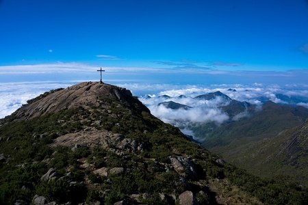
The Caparaó National Park was created on May 24, 1961, under President Jânio Quadros. It houses the third highest peak in the country, Pico da Bandeira. It is administered by the Chico Mendes Institute for Biodiversity Conservation (ICMBio). The Park has an area of 31,800 hectares. The park is located on the border between the states of Espírito Santo and Minas Gerais and occupies seven cities on the Espírito Santo side and four on the Minas Gerais side. About 80% of the park is in the state of Espírito Santo. Bandeira Mountain, with 2,891 meters, the highest point in the park, is located on the border of the states. Cristal Mountain, with 2,769 meters is exclusively in Minas Gerais territory.

This park is one of the most representative areas of Atlantic Forest in Espírito Santo territory, which in addition to covering much of the Caparaó Mountain Range, is also found on the slopes of the Castelo Mountain Range, Forno Grande and Pedra Azul. Caparaó is a branch of Mantiqueira Mountain Range, interconnecting with the Brigadeiro and Pai Inácio mountains in Minas Gerais. The park attracts many tourists, especially during winter holidays. Tourists come mainly in search of the cold climate, and to reach the summit of Bandeira Mountain due to its well-known view of the sunrise at the summit of the Cristal Mountain. The climate of the park region is tropical in altitude, of the Cwb variation and has mild temperatures, with annual averages between 19 ° C and 22 ° C, but the summits of the parks are very cold places, being some of the coldest points in Brazil, in them the temperature can vary from 25 ° C to -10 ° C, and in winter, the peaks register frosts and temperatures of -4 ° C daily. At Cristal Mountain, there is a lake where at least one day per year is recorded with ice cover on site.
Final Note (not the name of a park!). This is important, so read it please.
Well, we finished the first part of five, with images and information about each Brazilian national park. I started this series of blogs inspired in Kesuko, who is in the great endeavor, and challenge to visit each American national park. Some conversations (actually some images ... lol), and he decided to try to visit the Brazilian national parks, after the American ones (I hope this happens after the pandemic, if it happens.). This is basically a help for him, but I want to share this knowledge with everyone, showing that nature has a lot to offer us, with beautiful mountains, forests, rivers, dunes, waterfalls, etc.
I am finding it very interesting, discovering more about the nature of my own country, but the questions come to me: will people feel the same interest? Does it look like I "worship" and "boast" Brazil over other countries? Is this SPAM!? Also, excuse me if the formatting is strange (mainly in Mobile...). Despite I loved, I’m not 100% accustomed with The Blog Update, as I posted 29 times with the former editor. And I didn't found images for some parks, or more than one, so, excuse me again.
This is the blog I'm most nervous about posting. Every blog I post makes me sick to my stomach. I wonder if this is productive, interesting, or at least not stupid. But this blog is what makes me the most nervous. Wouldn't easier for me to show Kesuko, and that's it? I like to share my Brazil to the world, but doing it many times, and starting a series talking about Brazil makes me nervous. I'll post (in this case, it's already posted), but with the fear that you don't like it. I'm getting negative, but I have to try to do it. Perphaps people like?
I hope this post doesn't look weird like I'm thinking, but if you liked, stay open to the news here on my blog. Thank you very much for that minute of attention, and until the next post.
Lets make you visit all of them.You've come so far MG, and I can confidently say this is my favourite blog by you by far, as many people can appreciate the beauty of these parks!
The list are below
O que você tem em mente? Qual tema?
Mas, eu não sou bom em dar ou ter ideias. Eu escrevo blogs depois de pensar muito. Tive uns três ou quatro bloqueios criativos. Mas eu pensei... poderíamos fazer SVGS com os resultados do Brasileirão de Pontos Corridos das Séries A e B? Eu me inspirei num usuário chamado @elijahwade, e ele fez a versão das Copas do Mundo, mostrando os resultados. Tenho que perguntar para ele, mas acho uma ideia legal. Só vai ser difícil fazer com que ao acertar, o SVG fique com o nome da equipe. Tenho perguntar pra ele, e também pra outro usuário que eu converso também, chamado @ThatOneGuy25. Ele usa o Boxy, e está me ajudando bastante. Acho que posso perguntá-lo como fazer o que o Elijah disse, usando o Boxy. Será complicado, mas talvez essa ideia saia do papel.
P. S. Desculpa o comentário longo kkkkkkkkkk
Aparados da Serra National Park
Araucárias National Park
Serra do Itajaí National Park
Serra Geral National Park
São Joaquim National Park
Aparados' canyon looks awesome.
I have heard of the crime there, but I think in some area's it will be less prevalent right?
I only know the city of São José, in front of Florianópolis. But I think he must have liked it. Santa Catarina is a special state.
And crime in Brazil, is like rice with beans (indispensable in the Brazilian's lunch). Always happen, and is routine in the TV. In big cities mainly, even in Belo Horizonte. There is no news that does not mention any theft, kidnapping, murder, unfortunately. Security is vital here. Fortunately, I never directly faced crime, nor any family member.
It is a great place, though.