thumbnail

Draw all US, Canada and Mexico subdivision borders

Welcome sadists, to an expansion of an earlier torture device.
I do mean ALL borders
The bodies of water used is somewhat arbitrary, if at first you don't succeed, deny you ever tried.
Quiz by plattitude
Rate:
Last updated: August 19, 2021
You have not attempted this quiz yet.
First submittedAugust 17, 2021
Times taken10,466
Average score60.9%
Rating4.54
Report this quizReport
40:00
Enter answer here
0
 / 307 guessed
The quiz is paused. You have remaining.
Scoring
You scored / = %
This beats or equals % of test takers also scored 100%
The average score is
Your high score is
Your fastest time is
Keep scrolling down for answers and more stats ...
 
Border
Aguascalientes-Jalisco
Aguascalientes-Zacatecas
Alabama-Florida
Alabama-Georgia
Alabama-Gulf of Mexico
Alabama-Mississippi
Alabama-Tennessee
Alaska-Arctic Ocean
Alaska-British Columbia
Alaska-Pacific Ocean
Alaska-Yukon Territory
Alberta-British Columbia
Alberta-Montana
Alberta-Northwest Territories
Alberta-Saskatchewan
Arctic Ocean-Northwest Territories
Arctic Ocean-Nunavut
Arctic Ocean-Yukon Territory
Arizona-Baja California
Arizona-California
Arizona-Colorado
Arizona-Nevada
Arizona-New Mexico
Arizona-Sonora
Arizona-Utah
Arkansas-Louisiana
Arkansas-Mississippi
Arkansas-Missouri
Arkansas-Oklahoma
Arkansas-Tennessee
Arkansas-Texas
Atlantic Ocean-Connecticut
Atlantic Ocean-Delaware
Atlantic Ocean-Florida
Atlantic Ocean-Georgia
Atlantic Ocean-Maine
Atlantic Ocean-Maryland
Atlantic Ocean-Massachusetts
Atlantic Ocean-New Brunswick
Atlantic Ocean-New Hampshire
Atlantic Ocean-New Jersey
Atlantic Ocean-New York
Atlantic Ocean-Newfoundland
Atlantic Ocean-North Carolina
Atlantic Ocean-Nova Scotia
Atlantic Ocean-Prince Edward Island
Atlantic Ocean-Quebec
Atlantic Ocean-Rhode Island
Atlantic Ocean-South Carolina
Atlantic Ocean-Virginia
Baja California Sur-Gulf Of California
Baja California Sur-Pacific Ocean
Baja California-Baja California Sur
Baja California-California
Baja California-Gulf Of California
Baja California-Pacific Ocean
Baja California-Sonora
Belize-Campeche
Belize-Quintana Roo
British Columbia-Idaho
British Columbia-Montana
British Columbia-Northwest Territories
British Columbia-Pacific Ocean
British Columbia-Washington
British Columbia-Yukon Territory
California-Nevada
California-Oregon
California-Pacific Ocean
Campeche-Guatemala
Campeche-Gulf of Mexico
Campeche-Quintana Roo
Campeche-Tabasco
Campeche-Yucatan
Caribbean Sea-Quintana Roo
Chiapas-Guatemala
Chiapas-Oaxaca
Chiapas-Pacific Ocean
Chiapas-Tabasco
Chiapas-Veracruz
Chihuahua-Coahuila
Chihuahua-Durango
Chihuahua-New Mexico
Chihuahua-Sinaloa
Chihuahua-Sonora
Chihuahua-Texas
Coahuila-Durango
Coahuila-Nuevo Leon
Coahuila-San Luis Potosi
Coahuila-Texas
Coahuila-Zacatecas
Colima-Jalisco
Colima-Michoacan
Colima-Pacific Ocean
Colorado-Kansas
Colorado-Nebraska
Colorado-New Mexico
Colorado-Oklahoma
Colorado-Utah
Colorado-Wyoming
Connecticut-Massachusetts
Connecticut-New York
Connecticut-Rhode Island
Delaware-Maryland
Border
Delaware-New Jersey
Delaware-Pennsylvania
Durango-Nayarit
Durango-Sinaloa
Durango-Zacatecas
Florida-Georgia
Florida-Gulf of Mexico
Georgia-North Carolina
Georgia-South Carolina
Georgia-Tennessee
Guanajuato-Jalisco
Guanajuato-Michoacan
Guanajuato-Queretaro
Guanajuato-San Luis Potosi
Guanajuato-Zacatecas
Guatemala-Tabasco
Guerrero-Mexico
Guerrero-Michoacan
Guerrero-Morelos
Guerrero-Oaxaca
Guerrero-Pacific Ocean
Guerrero-Puebla
Gulf Of California-Sinaloa
Gulf Of California-Sonora
Gulf of Mexico-Louisiana
Gulf of Mexico-Mississippi
Gulf of Mexico-Quintana Roo
Gulf of Mexico-Tabasco
Gulf of Mexico-Tamaulipas
Gulf of Mexico-Texas
Gulf of Mexico-Veracruz
Gulf of Mexico-Yucatan
Hawaii-Pacific Ocean
Hidalgo-Mexico
Hidalgo-Puebla
Hidalgo-Queretaro
Hidalgo-San Luis Potosi
Hidalgo-Tlaxcala
Hidalgo-Veracruz
Hudson Bay-Manitoba
Hudson Bay-Nunavut
Hudson Bay-Ontario
Hudson Bay-Quebec
Idaho-Montana
Idaho-Nevada
Idaho-Oregon
Idaho-Utah
Idaho-Washington
Idaho-Wyoming
Illinois-Indiana
Illinois-Iowa
Illinois-Kentucky
Illinois-Lake Michigan
Illinois-Missouri
Illinois-Wisconsin
Indiana-Kentucky
Indiana-Lake Michigan
Indiana-Michigan
Indiana-Ohio
Iowa-Minnesota
Iowa-Missouri
Iowa-Nebraska
Iowa-South Dakota
Iowa-Wisconsin
Jalisco-Michoacan
Jalisco-Nayarit
Jalisco-Pacific Ocean
Jalisco-San Luis Potosi
Jalisco-Zacatecas
Kansas-Missouri
Kansas-Nebraska
Kansas-Oklahoma
Kentucky-Missouri
Kentucky-Ohio
Kentucky-Tennessee
Kentucky-Virginia
Kentucky-West Virginia
Lake Erie-Michigan
Lake Erie-New York
Lake Erie-Ohio
Lake Erie-Ontario
Lake Erie-Pennsylvania
Lake Huron-Michigan
Lake Huron-Ontario
Lake Michigan-Michigan
Lake Michigan-Wisconsin
Lake Ontario-New York
Lake Ontario-Ontario
Lake St Clair-Michigan
Lake St Clair-Ontario
Lake Superior-Michigan
Lake Superior-Minnesota
Lake Superior-Ontario
Lake Superior-Wisconsin
Louisiana-Mississippi
Louisiana-Texas
Maine-New Brunswick
Maine-New Hampshire
Maine-Quebec
Manitoba-Minnesota
Manitoba-North Dakota
Manitoba-Northwest Territories
Border
Manitoba-Nunavut
Manitoba-Ontario
Manitoba-Saskatchewan
Maryland-District of Columbia
Maryland-Pennsylvania
Maryland-Virginia
Maryland-West Virginia
Massachusetts-New Hampshire
Massachusetts-New York
Massachusetts-Rhode Island
Massachusetts-Vermont
Mexico City DF-Morelos
Mexico-Mexico City DF
Mexico-Michoacan
Mexico-Morelos
Mexico-Puebla
Mexico-Queretaro
Mexico-Tlaxcala
Michigan-Ohio
Michigan-Ontario
Michigan-Wisconsin
Michoacan-Pacific Ocean
Michoacan-Queretaro
Minnesota-North Dakota
Minnesota-Ontario
Minnesota-South Dakota
Minnesota-Wisconsin
Mississippi-Tennessee
Missouri-Nebraska
Missouri-Oklahoma
Missouri-Tennessee
Montana-North Dakota
Montana-Saskatchewan
Montana-South Dakota
Montana-Wyoming
Morelos-Puebla
Nayarit-Pacific Ocean
Nayarit-Sinaloa
Nayarit-Zacatecas
Nebraska-South Dakota
Nebraska-Wyoming
Nevada-Oregon
Nevada-Utah
New Brunswick-Nova Scotia
New Brunswick-Quebec
New Hampshire-Quebec
New Hampshire-Vermont
New Jersey-New York
New Jersey-Pennsylvania
New Mexico-Oklahoma
New Mexico-Sonora
New Mexico-Texas
New Mexico-Utah
New York-Ontario
New York-Pennsylvania
New York-Quebec
New York-Vermont
Newfoundland-Nunavut
North Carolina-South Carolina
North Carolina-Tennessee
North Carolina-Virginia
North Dakota-Saskatchewan
North Dakota-South Dakota
Northwest Passages-Nunavut
Northwest Passages-Quebec
Northwest Territories-Nunavut
Northwest Territories-Saskatchewan
Northwest Territories-Yukon Territory
Nuevo Leon-San Luis Potosi
Nuevo Leon-Tamaulipas
Nuevo Leon-Texas
Nunavut-Saskatchewan
Oaxaca-Pacific Ocean
Oaxaca-Puebla
Oaxaca-Veracruz
Ohio-Pennsylvania
Ohio-West Virginia
Oklahoma-Texas
Ontario-Quebec
Oregon-Pacific Ocean
Oregon-Washington
Pacific Ocean-Sinaloa
Pacific Ocean-Washington
Pennsylvania-West Virginia
Puebla-Tlaxcala
Puebla-Veracruz
Quebec-Newfoundland
Quebec-Vermont
Queretaro-San Luis Potosi
Quintana Roo-Yucatan
San Luis Potosi-Tamaulipas
San Luis Potosi-Veracruz
San Luis Potosi-Zacatecas
Sinaloa-Sonora
South Dakota-Wyoming
Tabasco-Veracruz
Tamaulipas-Texas
Tamaulipas-Veracruz
Tennessee-Virginia
Utah-Wyoming
Virginia-District of Columbia
Virginia-West Virginia
+5
Level 86
Aug 19, 2021
Very nice indeed. I guess this is a spherical projection? That's the best you could do for a continent-sized quiz. It can be disturbing not to have vertical meridians, but I much prefer this to a Mercator projection, especially with a boreal country as Canada.

The design is much cleaner too, all the states are well-drawned. Maybe the lines look a bit too faint, but they are perfect in zoom. The only thing that I could ask for is a wider map (as it is, it stops at about 3/4 of the answer columns' width).

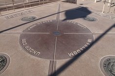
About what seems to be a "four corners" in Mexico, I don't think that's correct. I looked on Google maps, and it seems there is a 1,5km border between Zacatecas and Guanajuato, and no border between Jalisco and San Luis Potosi.

Anyway, this is too well-designed not to be featured.

+3
Level 92
Aug 19, 2021
Cheers! Yeah, I like this a lot more than the Mercator used previously, especially when trying to add Mexico.

For the width, it's actually an issue with the shape of the map. JetPunk limits the size of an svg to 630h x 800w. To make this image as large as possible, it's 630h x 563w. However, the minimum width of the quiz columns is 730, so I haven't seen a way to reconcile the extra 200 px.

As to the Mexican 4 corners... I'm not sure. When I came across it in the SVG, the symmetry of each of the 3 countries having a 4-corners site was so pleasing, I didn't look into it further. Google Maps seems to indicate no border between JC and SLP, but Britannica lists them as bordering each other. I'll look into it further.

+3
Level 52
Aug 22, 2021
This is my new favourite quiz. Perfect to pass the time!
+7
Level 59
Aug 23, 2021
Absolutely beautiful torture device - thank you for creating this! Am refreshing your quizzes page once a day in the hope that one day I see a body of water / all borders quiz like this made by you but for the whole world... one can dream!
+5
Level 92
Aug 23, 2021
Masochist.

I might do that (though at the country level, not the state/province level), but I'd really have to nail down which bodies of water to use. Does Italy, for example, border just the Mediterranean Sea, or does it border the Adriatic, Ionian, Tyrrhenian, and Ligurian? And if Sardinia borders the Tyrrhenian on the east, what does it border on the west, just the Mediterranean? Multiply that by the ~200 countries in the world... would require some thinking.

+2
Level 59
Aug 23, 2021
Complete glutton for punishment here, I'll admit! Badly phrased by me earlier, I also meant on the country level rather than state/provision/ sub-division level. Raises so many interesting questions - I like how islands would be included in a 'borders' quiz as you'd have to include e.g. Jamaica / Caribbean Sea....

I imagine you'd have to be somewhat arbitrary again, e.g. is the Caspian Sea included? I think probably for sanity/ size of quiz it would be Italy as just the Med rather than all of those individual sub-divisions of it, but an interesting dilemma to have!

+4
Level 92
Aug 23, 2021
And then you get into the business of all the overseas territories, which create borders between Seas and Countries halfway around the world... (looking at you Pitcairn... and Reunion.. and about half of the Caribbean...)

Oh, and Antarctica. Is it a 'border' if the claimed territories overlap? And what about the areas no country has claimed, does New Zealand border "Terra Nullius" down there? Maybe I should just ignore Antarctica since everyone else does. But by that logic, I should ignore New Zealand, so...

+2
Level 59
Aug 25, 2021
All great points! For what it's worth, I'd ignore Antarctica, but include almost everything else! France bordering Netherlands on Saint Martin / Sint Maarten, Spain bordering Morocco, UK bordering Gibraltar etc. - all would be fair game.

Now I'm starting to think how many seas/coastlines the UK would technically border and my head is starting to hurt!

+2
Level 92
Aug 25, 2021
All right, so I started building this map. I'm breaking down the countries in alphabetical order, and am now up to Ireland, so the UK is still a ways off. Indonesia nearly killed me deciding which seas/straits/bays/gulfs to include and which to blend into a larger body. Walking a tightrope between what's remotely possible and torturing you for putting this idea into my head...
+1
Level 59
Aug 26, 2021
Frustrated I only saw this today! Luckily I know you'll be somewhere in the middle of this mad, mad endeavour. If it helps with motivation, part of your arbritary decision making and 'deal with it' attitude is my favourite thing about your quizzes and maps!

Apologies for putting this insane idea in your head but I can't wait to see what comes out of it...

+2
Level 92
Aug 27, 2021
It's getting close. I just did a test run through it, and found a couple small issues:Missing a couple small borders--uk/spain, france/nederlands,Order of entry matters on a couple borders: saudi/persian, south china sea/vietnam

Here's the preview if you'd like to give it a beta test.

+1
Level 59
Aug 27, 2021
I'd love to give it a test! The preview link doesn't work for me though, 404 File Not Found:/
+1
Level 92
Aug 27, 2021
Ah darn. I wonder if it's a permissions thing. Here's the live quiz.
+1
Level 59
Aug 27, 2021
This is incredible! I am so so excited to try this. Trying imminently...
+3
Level 65
Aug 24, 2021
I'm sure this is a good quiz, but no way I'm spending that much time to do all the Canada and US border (idk any Mexico subdivision)
+2
Level 92
Aug 25, 2021
You, my friend, are among the sane and happy. Stay there. Don't go down this rabbit hole :)
+1
Level 83
Sep 9, 2021
I think you’ve missed the Nuevo León-Zacatecas border.
+1
Level 92
Sep 9, 2021
Interesting, I'm not solid on Mexican geography (part of the reason I made this quiz). The map I worked off of had San Luis Potosi bordering Coahuila, and thus the two of them separating Zacatecas and Nuevo Leon, but Google Maps disagrees. It's on my to do list now!
+1
Level 88
Nov 5, 2021
Wow, this is really something. I'm pleased that I managed to do as well as I did, but there's plenty of room for improvement. I'm not sure I have the mental fortitude to try again any time soon though. Anyway, this is quite the quiz, excellent effort!
+1
Level 92
Nov 7, 2021
Cheers, I had a lot of fun with this one.

Curiosity, did you choose your name from the band, or the Roald Dahl novel?

+1
Level 88
Nov 7, 2021
From Roald Dahl. I didn't realize there was a band by the name, I'll have to check them out.
+1
Level 55
Nov 5, 2021
This is amazing! I wonder how annoying it must've been to do all the type-ins...
+2
Level 92
Nov 7, 2021
Not quite as annoying as you might think. Basically using Excel, just perfect the type in for each individual state/province/body of water, then use concatenation to assemble them into one large regex for each answer which allows them to be entered in any order, and include that regex as part of the answer import.
+1
Level 55
Mar 19, 2022
that's genius, I use excel functions for the importing/exporting of some of my bigger quizzes and I never knew you could do that
+1
Level 48
Jan 4, 2022
I love this quiz it's the ultimate challenge
+1
Level 53
Jan 24, 2022
I mean 212/307 on my first try isn't bad at all. I know Canada and States pretty well, but not Mexico. I guess I havet to practice Mexico's geography before trying this one again.

Huge thank you for making this! One of my favourite quizzes so far. I appreciate your work.

+1
Level 62
Jan 28, 2022
Jalisco does not border San Luis Potosi.
+2
Level 62
Jan 28, 2022
Quebec also borders Nunavut, but only barely.
+2
Level 92
Jan 29, 2022
Where?
+2
Level 74
Dec 15, 2023
Teeeeeechnically it borders on Killiniq Island (against Kativik, QC) because the water changed the shape of the island and a TINY bit of Nunavut is now on the Ungava peninsula.

Also, no, sadly, no four-corners in Mexico; there's 1870 meters of Zacatecas separating Jalisco and San Luis Potosí.

Next comment will have the abbreviations for you in case you are curious.

+1
Level 74
Dec 15, 2023
Canada:

AB Alberta

BC British Columbia

MB Manitoba

NB New Brunswick

NL Newfoundland & Labrador

NS Nova Scotia

NT Northwest Territories

NU Nunavut

ON Ontario

PE Prince Edward Island

QC Québec

SK Saskatchewan

YT Yukon Territory

US:

AK Alaska

AL Alabama

AR Arkansas

AZ Arizona

CA California

CO Colorado

CT Connecticut

DC District of Columbia

DE Delaware

FL Florida

GA Georgia

HI Hawaii

IA Iowa

ID Idaho

IL Illinois

IN Indiana

KS Kansas

KY Kentucky

LA Louisiana

MA Massachusetts

MD Maryland

ME Maine

MI Michigan

MN Minnesota

MO Missouri

MS Mississippi

MT Montana

NC North Carolina

ND North Dakota

NE Nebraska

NH New Hampshire

NJ New Jersey

NM New Mexico

NV Nevada

NY New York

OH Ohio

OK Oklahoma

OR Oregon

PA Pennsylvania

RI Rhode Island

SC South Carolina

SD South Dakota

TN Tennessee

TX Texas

UT Utah

VA Virginia

VT Vermont

WA Washington

WI Wisconsin

WV West Virginia

WY Wyoming

+1
Level 74
Dec 15, 2023
Mexico:

AGS Aguascalientes

BC Baja California

BCS Baja California Sur

CAMP Campeche

CHIS Chiapas

CHIH Chihuahua

COAH Coahuila

DF Distrito Federal (sometimes CDMX)

DGO Durango

EDOMEX México (or just MEX)

GRO Guerrero

GTO Guanajuato

HGO Hidalgo

JAL Jalisco

MICH Michoacán

MOR Morelos

NL Nuevo León

NAY Nayarit

OAX Oaxaca

PUE Puebla

QROO Quintana Roo (also sometimes QR)

QRO Querétaro

SLP San Luis Potosí

SIN Sinaloa

SON Sonora

TAB Tabasco

TAMPS Tamaulipas

TLAX Tlaxcala

VER Veracruz

YUC Yucatán

ZAC Zacatecas

+2
Level 81
Jan 28, 2022
Love the quiz. A couple suggestions around the Canadian borders:

1. Manitoba/Nunavut/Saskatchewan/NWT form a four-corners scenario like the one between Colorado/Utah/NM/Arizona.

2. Include James Bay (the one sticking out the bottom of Hudson Bay).

+3
Level 92
Jan 29, 2022
Of course they do... Which is why they're answers on the quiz.
+1
Level 65
Jan 28, 2022
Not sure jalisco and san luis potosi share a point, but they're close.
+1
Level 92
Jan 29, 2022
Yeah, the map ain worked off of had a quadripoint there z I haven't gone back and fixed it yet.
+2
Level 90
Feb 12, 2022
Northwest should be a type in for both Northwest Territories and Northwest Passage.
+2
Level 92
Feb 12, 2022
I disagree.
+2
Level 72
Apr 5, 2022
If you're going to say the quiz really does ask *all* first-level subdivision borders, you really ought to include the US territories. Not including them is a reasonable decision, but warrants a note to that effect imo. I did spend a minute trying a few of them to no avail.

Also I'm not entirely sold on including Lake St Clair and not Lake of the Woods or Lake Champlain. The Great Lakes seem fair game, but I question whether St Clair is really the next most important lake.

Also also for some reason my brain refused to actually type all the four-corners borders, it just went "yes that's a 4-corners", moved on to the next thing, and never came back. grr.

+2
Level 92
Apr 5, 2022
Very reasonable points. This quiz is on my back burner right now, but I'll make the changes next time I do an update here.
+1
Level 72
Apr 6, 2022
Fair enough. Thanks for the response!
+1
Level 63
Jun 14, 2022
Could you add the newly created (as of today, June 14, 2022) Nunavut-Greenland border on Hans Island?
+2
Level 92
Jun 14, 2022
Yep, I'll add it here as well. As soon as I can find the time :)
+1
Level 59
Jul 14, 2022
so ashamed of myself rn. I thought the line cutting off Hawaii was the first line I had to draw from, and had no idea which subdivision it was
+1
Level 90
Oct 6, 2022
The Newfoundland-Nunavut border is not in the correct alphabetical position in the answer grid. It should come between the New Brunswick borders and the New Hampshire borders.
+1
Level 92
Oct 7, 2022
That would be the case if it were "New Foundland". Spaces are sorted above letters, so all "New " names will come before "Newark." Put them in excel and try it yourself.
+1
Level 59
Mar 9, 2023
215/307. Missed some obvious ones.

Also 90% of Mexico

+1
Level 68
Jun 27, 2023
If only I knew that Nunavut was not spelt Nunavit.
+3
Level 92
Jun 27, 2023
Misspellings? We'll have none of it.
+1
Level 56
Jul 23, 2023
I think that Nunavut borders Quebec. In Google Earth, if you zoom in really closely near where Nunavut and Newfoundland border, and follow the Quebec/Nunavut line you can see that it clearly passes through a touch of green on some random tiny islands and is therefore a land border and not temporary sea ice. Google Earth isn’t exactly the best source, and thus it may just be alignment issues or old images but I think it’s worth looking into.
+1
Level 63
Aug 29, 2023
I’ve looked into this many times and (much to my disappointment) haven’t been able to find anything verifying such a border.

This discrepancy is actually my main driving factor for never trusting the borders found on google maps.

+1
Level 67
Sep 23, 2023
"nuevo leon texas" doesn't work :(
+1
Level 92
Sep 29, 2023
It really does.
+1
Level 44
Oct 27, 2023
Can you please put “Northwestern Passages” and “Northwestern Territories” as a type-in?
+2
Level 53
Dec 2, 2023
This deserves to be a featured quiz!
+1
Level 92
Dec 4, 2023
Thanks sophiee!
+1
Level 74
Dec 15, 2023
I agree... unfortunately it has too many answers to be featured, but I'm nominating it anyway. Also spotlighting it and it will be on the front page on 22 December. Fantastic, fantastic work.
+1
Level 92
Dec 17, 2023
Nah, my claim to fame is the world version which has 799 answers in its current iteration.
+1
Level 38
Mar 14, 2024
I knew the Nunavut-Newfoundland and Labrador border was there. Guess I am in the 27%! :)