The Problem with Continents and Islands
First published: Monday July 18th, 2022
Report this blog
What is a continent?
Continuous Landmass
One definition of continent is that it is a continuous landmass. This is the least ambiguous definition. Basically if it's a landmass larger than Greenland or maybe Australia then it's a continent. Any island is by definition excluded except sometimes fluvial islands and temporary islands (I didn't say it was free of ambiguity).
This creates a lot of problems. Like, I can drive to visit my grandparents on the Île d'Orléans and I won't be in North America anymore? That makes no sense. Also, Afro-Eurasia would become one continent, depending how you classify canals. Aside from common sense, though, this definition is okay.
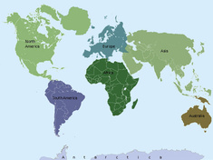
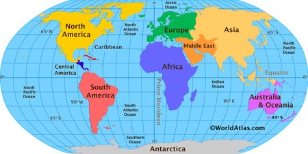
Traditional Continents
The traditional continents are the ones we are all used to. Europe, Asia, Africa, South America, North America, Antarctica and sometimes Australia. These make a lot of sense (except for Europe) and actually look like real continents on a globe. These helpfully include surrounding islands so I no longer have to leave all continents to visit my grandparents.
That's not to say this is without problems, the most glaringly obvious one being: what continent is Cyprus on?
Dealing with Islands
Dealing with islands is a big problem and will make people mad no matter how you do it. The inland and coastal islands are generally not problematic, but when we venture into the middle grounds in the oceans and seas, we run into problems.

Geopoliticultural Categorization
I think I just made up that word, but it's the reason that North America sneakily snagged Hawaii and the Caribbean on many world maps. It also creates a basis for splitting Cyprus into two continents based on geopoliticultural lines. That makes no sense though, so here we are...
This island categorization scheme isn't the worst, but it's the reason for the problem in the first place.
Proximity Categorization
Just assign the island to it's closest continent. It's what the QM did to Cyprus and it can work for you too. But this rarely gets used because... tectonic plates and politics and stuff
Drawing Random Lines
Because other people than me notice the problem, they draw random lines across the world hoping to classify the most random islands. It rarely works and their ideas are fairly dumb.
My Opinion
A short summary of my plan:
Merge Europe and Asia.
South America gets the Lesser Antilles.
Austrindomelamicropolynesia becomes a continent spanning Australia, Indonesia, Melanesia, Micronesia and Polynesia.
Dumb islands like Saint Helena etc. can be forgotten about.
These subdivisions of America are more for cultural than geographical reasons imo. I’d say the islands of Caribbean belong to Central America, but at Trinidad and Tobago question, it’s hard to say
although I’m more like to say that they’re in North America“The [continent] debate is basically us with modern geographic and cultural knowledge trying to justify the inconsistencies and hypocrisies of past geographers, instead of moving on and realizing continent aren't the perfect land division” - Me on JetPunk 2021
:D
Austrindomelamicropolynesia............................That's Oceania! I wish Oceania was the official continent name > Australia.
St. Helena is Africa. For dumb islands, it's what they are closest to. (And a bit of who owns them)
I like the N. America/ S. America Divide as it is.
Europe Asia split makes sense, as they have much different cultures. While Asia in and of itself is diverse, joining with Europe is even worse.
-
-
And ofcourse, Cyprus is in Africa