Exploring Canada's Territories - #4 Northern Canada
First published: Sunday December 12th, 2021
Report this blog
The Final Stretch
Last time, I finally finished talking about every single Canadian province, ending it off with a bang in Atlantic Canada. However, Canada is not just about the ten provinces. Often left out of discussion, now we must cover the three northern territories. But this will not be a burden. for they happen to be some of the most unique and fascinating parts of the country!
Get your gold-pan ready. today we're going to strike it rich, b'y :)
Northern Canada
What is a territory? Contrary to popular belief, the territories do in fact have a government. However, they have their powers given to them by the Parliament of Canada, while the provinces get all their powers from the Constitution Act, 1867. Therefore, in order to change the power given to provinces, you would have to change the Constitution, while for territories you only need the decision of the Federal government.
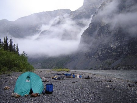
Canada's territories typically exist above the line of 60º north, with exceptions. This gives them at least 19 hours of daylight during the summer solstice, and less than six hours during the winter solstice (although this is at the border, the situation is much more extreme in many communities).
The territories are almost certainly the most obscure part of Canada, containing an estimated ~125,000 people combined, less than 1% of Canada's population. Due to their remoteness, it's safe to say that many Canadians will never visit this region of the country in their lives.
• Yukon

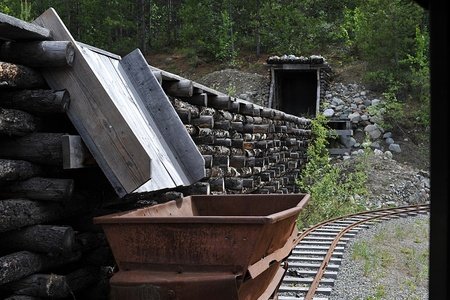
Yukon, the land of the prospector, the Klondike. I think it's safe to say that many people imagine rugged, opportunistic miners, perhaps trudging through deep snow in the hostile mountains, all in hopes of finding some capital. And this is true, the Yukon was in fact the stage of 100,000 miners after news of gold broke out, from 1896-99, decades after the end of the Cariboo Gold Rush. However, this gold rush was short-lived, and as newspapers moved on to the excitement of the Alaska Gold Rush, so did most of the prospectors. Yukon's population quickly fell to around 5000 by 1920, and I'm not sure how many of those people were the Indigenous people who were displaced during the Gold Rush.
Despite being more than a hundred years in the past, the prospector's spirit still haunts Yukon, both through the ruins of wooden mining structures that can be found across the sparsely populated land, but also the lovely licence plate featuring a prospector and his dog.
Speaking of dogs, husky dogs are another icon of the territory, and both Siberian and Alaskan breeds are involved in the massive Yukon Quest sled dog race, an over 1600 km long race from Fairbanks, Alaska to Whitehorse, Yukon, called the 'toughest race on earth'. The creators of the race deliberately wanted a rugged competition so that only purists would even consider joining.
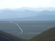
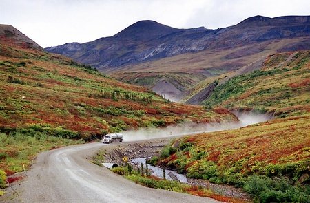
In terms of tourism, Yukon has a culture of big open roads, with hauntingly empty vistas. The Alaskan Highway is amongst the most famous drives in Canada, and despite being paved and much more accessible than it was upon construction 70 years ago, it retains a level of prestige. Large groups of motorcycles are a common sight on the road. There is another, more legendary route which begins in Yukon, but most of it is in the Northwest Territories so I'll talk about it in a bit. Germans love to visit the Yukon, and they make up a large portion of foreign tourism, second only to Americans. This CBC article takes a few guesses at why it is popular, including the scope of nature, German interest in the Indigenous culture (although Yukon is the only territory where European Canadians are a majority of the population, not Indigenous people), pre-existing accommodation catering to German tourists and the seasonal direct flight from Frankfurt to Whitehorse. Newcomers to Yukon are called cheechako, although I'm not sure how common the word is today.

Yukon has plenty of geographic wonders within its borders. For example, just south of Whitehorse you can explore the Miles Canyon, a volcanic formation carved by the Yukon River. Even further south, the Carcross Desert springs to mind. A popular sandboarding site, it is commonly referred to as the world's smallest desert (although in actuality it is a dune, and is too humid to be considered a desert despite the rain shadow from surrounding mountains keeping it somewhat dry). On the top of Yukon lies Herschel island, the only offshore island of the territory with a whaling history and a staggering population of 0.
Population-wise, Yukon is nearly synonymous with Whitehorse, as that city alone comprises almost 70% of the territory's population. In some ways, it sounds like a more extreme version of British Columbia, with lower religiosity and high expenses, albeit with much less immigration. Almost 5% of Yukon speaks French as a native language, followed by German and Tagalog with over 2% and 1%, respectively.
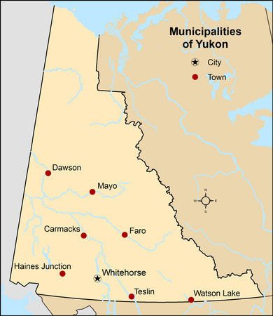
(I won't be doing regional maps from now on, as the territories are all too sparse to be divided like I did with most of the provinces). There are a whopping total of eight municipalities, containing 80% of Yukon. Everyone else is either rural or in unincorporated communities. 98% of Yukon's land is unorganised, and is legally classified as 'out in the sticks' by Statistics Canada.


Some important cities include:
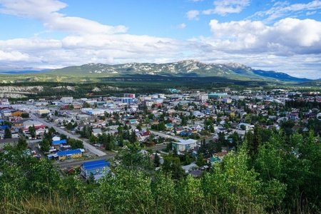
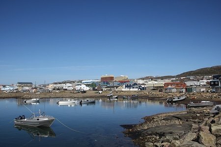
Whitehorse - A quickly growing city and the largest in any of the territories, Whitehorse is named for the rapids that once existed on the townsite, prior to the damming of the Yukon River. Whitehorse enjoys a mild climate for its northerly position, with the average temperature only plummeting to -15°C during January (keep in mind this is still better than cities like Yellowknife), and additionally it is the westernmost city in Canada. The city has a varied geography, with the city centre being the same level as the river, while other neighbourhoods are located higher up on the banks or further out in the valley. In winter, the Yukon Sourdough Rendezvous Festival celebrates impressive and detailed snow sculptures, while other attractions include the restored SS Klondike sternwheeler ship and the Takhini Hot Springs. Yukon University, formerly a college, is the only university institution in any of the territories.
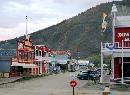
Dawson City - Once the capital of Yukon, until 1952 after the Alaska Highway's completion took all the business south to Whitehorse, this frozen-in-time town is now a tourist destination. Although gold mining is still a big economic factor, tourists are drawn to the 19th Century gold-mine boomtown façades of the streetscapes, a style all new builds must comply with, too. Melting permafrost is a risk to these structures, however. Downtown Hotel serves the famous Sourtoe Cocktail, a cocktail featuring a real-life, mummified human toe. Originally from a prohibition-era outlaw's frostbitten toe, several more toes have been donated throughout the years, due to some going missing or getting damaged. In 2013, the fine for swallowing the toe was $500 dollars. However, this was increased when a customer walked in, swallowed the drink + toe, slapped $500 on the table and left. The fine is now $2500.
Watson Lake - Just 7 km north of the BC border, near the Liard River, you can find the highway-town of Watson Lake. Prior to 1942, there was a simple signpost located here, pointing to various cities and how far away each was. However, it was damaged by a bulldozer during the construction of the Alaska Highway. American GI Carl K. Lindsay was ordered to repair the sign, and, feeling homesick, he put up a sign pointing to his hometown of Danville, Illinois. This began a trend, and more signposts were added throughout the years. Today, you can find over 80,000 signposts in what has become the Sign Post Forest.
Old Crow - This Gwich’in community is located in the far north of the territory, above the Arctic Circle at 67° north. The town was founded by Deetru` K`avihdik (Crow-May-I-Walk, in English) in the 1870s, and today the town still relies on the trapping of animals, including Porcupine caribou used for food and clothes. Old Crow is the only community in Yukon without road access, and even establishing communications here has historically been a challenge, as has been the case in other small towns in the territories. Alcohol is prohibited in the town, the northernmost non-Inuit community in all of North America.

• Northwest Territories

Named due to its location northwest to the former Rupert's Land (the Hudson's Bay Company's territory), the Northwest Territories has long been synonymous with the great frontier. After absorbing Rupert's Land, this vast territory would have massive areas of land carved out of it to create Alberta and Saskatchewan, and enlarge Quebec, Ontario and Manitoba as European settlement 'tamed' this wilderness. More recently, the territory was split in half to create the Inuit-majority territory of Nunavut.
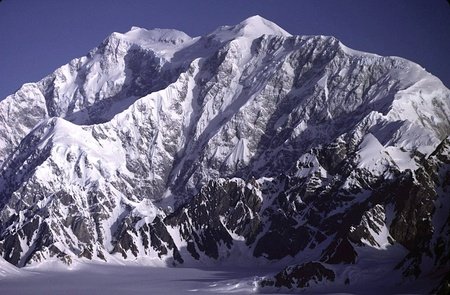
Today, the Northwest Territories still captures the 'frontier' image, and houses few communities in favour of empty, beautiful landscapes, many of which incredibly remote and hard to access. The territory is probably best defined by the mighty Mackenzie River, Canada's longest river notorious for its width, as well as the Great Slave and Great Bear Lakes, the largest freshwater lakes located entirely within the country.
Nahanni National Park can be found in the mountains to the southwest, home to impressive canyons and mountains. Here you can find Virginia Falls, which are almost twice the height of Niagara Falls, at 96 metres, divided by Mason's Rock. Are you a fan of stories? The local people speak of the Naha people in their oral history said to have lived in the mountains where they conducted raids on local people. Mysteriously, they disappeared, however their legends lived on in the tales of prospectors looking for gold during the Klondike Gold Rush. No gold was found on the Nahanni River, however in 1908, the headless corpses of two Métis brothers were found, and a rumoured lost gold mine was named after them, the McLeod mine. Searching for this mine has claimed the lives of 20 more men, some under mysterious circumstances. Calgary geologist, Frank Henderson, visited the area in 1946 with his partner, Jack Patterson. Patterson ended up disappearing, with no sign from him after weeks. Henderson camped in the valley for a few more nights, until the local First Nations people woke them, warning them of white figures moving along the valley. Upon visiting the valley next year, Yukonian writer Pierre Berton reported on the 'sinister' feel of the valley, and the haunting wail of the wind.
As a result of these incidents, the valley is known as Headless Valley, or Deadmen Valley, and it is marked on Google Maps. While it makes for a nice read, I cannot verify any of the story. I got all the information from this Wikipedia article, which echoes the words of the Parks Canada website. If you Google the case, you will come across a bunch of unreliable, sensationalist/clickbaity articles and videos. Still, it makes me interested in what otherwise would look like just another valley :)
In addition to French and English, the Northwest Territories has made nine Indigenous languages official. Despite the multiple official languages, access to services outside of the court is not guaranteed, so the recognition is more ceremonial than anything.
Indigenous people make up just over 50% of the territory's population, with First Nations people comprising the largest group within the category. First Nations are not grouped with Inuit people, whom are all culturally related to one another, and originate from the Thule people in modern-day Alaska around the year AD 1000, replacing the older Dorset culture. As I mentioned in an earlier blog, the Métis are of mixed European-Indigenous descent, and historically have either French or Scottish heritage.

Some Indigenous groups include the Chipewyan (also known as Dené, or Dënësųłinë́, pronounced [tènɛ̀sũ̀ɬìnéjàtʰìɛ́]), Slavey and Gwich’in (Athabaskan) people, the Cree (Algonquin) and the Inuit groups to the north. The Navajo in the American Southwest are also Athabaskan language-family speakers, and legend has it they are the earliest Canadian snowbirds, having entered the territory around AD 1400.
As I alluded to in the Yukon section, the legendary Dempster Highway stretches all the way from the Klondike Highway in the Yukon, north to the Arctic Ocean and Tuktoyaktuk on the Arctic Ocean. As of 2017, the final stretch between Inuvik and Tuktoyaktut has been bridged by permanent all-weather road, when formerly it has to be crossed in winter via ice roads. This is truly a great drive, taking motorists over unpaved wilderness roads between remote settlements.
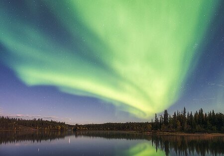
The Northwest Territories is probably best known for both viewing the Northern Lights/Aurora Borealis, (a popular tourist activity in Yellowknife), and the bear-shaped licence plates. Introduced in 1970 for the territory's centennial, these unique plates are a registered trademark of the Northwest Territories' government.

Most of the municipalities are concentrated either to the south (where they are connected via roads to Alberta), or to the north (where they are connected via the Dempster Highway to Yukon). Communities around Norman Wells are only accessible in the winter via ice roads, in the summer via navigating the Mackenzie River or, most commonly, by flying. Communities in the north are primarily Inuit, while in the south there are more First Nations, Métis and European Canadians.
Yellowknife is home to just under 50% of the territory's population.

Some important cities include:
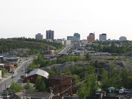
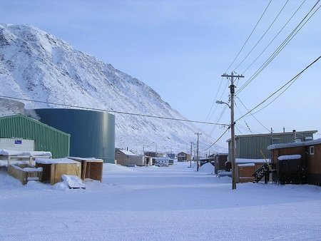
Yellowknife - Yellowknife has a very distinct look, with its rocky, Canadian Shield landscape and relatively tall buildings, at least for a city of nearly 20,000 people. Originally settled as a mining town on the northern shore of the Great Slave Lake, Yellowknife is known for its very cold winters (here is what the city looks like at -40°C), and in 2014 it was awarded the title of 'coldest, but sunniest city in Canada', although only cities with more than 10,000 people were considered. Old Town Yellowknife is home to buildings/houses with a distinct architectural style, as well as docks, businesses (including the famous Wildcat Cafe, located in an old log cabin), all on a peninsula jutting out into the lake. This is the centre of Yellowknife's tourism, and in the winter the lake freezes over, allowing for the Long John Jamboree ice sculpting event to commence.
The city is also well known for a certain road, originally named during the 1970s by Lou Rocher and his friends as a joke about how broke they were after a rough prospecting season. Yellowknife was very reluctant to accept the street's name due to the city's desire to retain its PG rating, and after signs were finally installed they became popular targets of theft. If you want to learn more, it's pretty easy to find the road on Google. It's only a minor cuss word, nothing to get too excited about, but I don't want to break JetPunk policy.
Inuvik - On the edge of the tree line in the far north lies the town of Inuvik, built in 1953 to replace Aklavik on the neighbouring Mackenzie Delta as the regional centre, as the latter is prone to flooding. Inuvik's 3,000 strong population is around 70% Indigenous, with an Inuit (Inuvialuit) plurality and a Gwich’in minority, and during the Muskrat Jamboree festival at the beginning of spring, the town enjoys traditional activities such as games, dog-sled (or snowmobile) races and a hockey tournament, all while enjoying soup, bannock, pastries and coffee/Labrador tea/hot chocolate. Many participants wear traditional clothing to the event. Inuvik has a famous, beautiful church shaped like and igloo, and this is the most photographed building in town. It also contains one of the northernmost mosques in the world, dubbed "little mosque on the tundra" after a somewhat obscure CBC show, and due to the long daylight hours the Ramadan feast is broken at 7:00 pm sharp in accordance with Muslims in Mecca.
Hay River - A majority First Nations town on the Southern shores of Great Slave Lake. The town, known as the 'Hub of the North', is split into an old town, along the shore, and a new town further up the Hay River, across from the airport (established here to avoid flooding). Like many other Northwest Territories towns, Hay River is steeped in the economy of the mines, and the population fluctuates depending on how well they're doing.
Fort Smith - Fort Smith is located directly on the Alberta-Northwest Territories border, close to the spot of an old portage route on the Slave River. In the winter, ice roads connect this town, the centre for Wood Buffalo National Park, down to Fort McMurray. A slight plurality of the population is First Nations, and the town has a tourism industry thanks to its history (including missionary history) and proximity to Wood Buffalo, the majority of which is located in Alberta.
Behchokǫ̀ - Pronounced [bɛ́ht͡ʃʰókʰõ̀] or [bɛ́ht͡sʰókʰõ̀] in the Tłı̨chǫ/Dogrib language, and 'beh-cho-KO' in English, this is the largest Dene First Nations community in Canada. Formerly named Rae-Edzo, the community sits in the Hudson's Bay Company site of a winter post, built close to where the Dene families lived in order to facilitate greater trade, known as Fort Rae. Found on the northern arm of Great Slave Lake, concerns of sewage contaminating the drinking water led to the founding of Edzo, several kilometres away alongside the Highway to Yellowknife, although most families remained in Rae creating two far apart centres under one government. In 2005, the name was changed to Behchokǫ̀ when the community became incorporated.

• Nunavut

Nunavut is, quite simply, Canada's version of Acre in Brazil - i.e. most Canadians have never met a Nunavummiut, or even thought about visiting the territory (thanks $2500 airplane tickets), so we can joke that it may not even exist. To add to its obscurity, there are no roads to Nunavut. Every single community in the territory is fly-in only. The territory is quite new, too, and was only carved out of the Northwest Territories in 1999.
So, what is a Nunavut? Quite simply, it was established as a territory as per Inuit land claims. There have been proposals to divide the Northwest Territories based on ethnic lines since the 1950's, and after certain abuses in the 1950s (which I will cover in a moment), there was more Inuit demand for recognition and compensation. In 1982, citizens voted to divide the Northwest Territories, and in 1992, 69% of people living in what would become Nunavut voted to succeed and become their own territory.
Nunavut (or ᓄᓇᕗᑦ) is one of just two provinces/territories where English is not the primary language, with the other being Quebec. Inuktitut is the majority mother-tongue of Nunavummiuq (people from Nunavut, plural), and is official in the territory alongside English, French and Inuinnaqtun. Inuktitut is written using the fascinating Inuktitut syllabic abugida (ᖃᓂᐅᔮᖅᐸᐃᑦ), introduced by Moravian missionaries and adapted from Cree syllabics, themselves created by missionary James Evans. Evans based these syllabics off of his knowledge of the Devanagari abugida, but adapted them to fit the Cree language. Similarities can be seen in certain characters (compare syllabic ᓂ with Devanagari नी, both sounding something like [ni]). Very simply put, the appearance of the characters tells you the consonant, and the rotation tells you the vowel sound. Therefore, ᐱ = pi, ᐳ = pu, and ᐸ = pa. You can read more about it here.
Due to the erosion of traditional Inuit languages, a plan to create a bilingual society was put forwards in the year 2000. This includes a Qulliq Model is most schools (meaning education is in Inuktitut), revitalisation of the Inuinnaqtun language in its traditional communities of Kitikmeot Region, and a mixed model for Iqaluit, as 40% of the population is non-Indigenous there. In 2016, 90% of Inuit people spoke an Inuit language. Stop signs in Nunavut are famously bilingual, displaying Inuktitut syllables alongside English: STOP.
A majority of Nunavut's economy is based on the mining of iron ore and gold. Although the GDP per capita is relatively high, at just over $56,000 per capita, but a high percentage of people are low-income. On top of this, food is incredibly expensive, as everything must be imported to the remote communities. If you want to see for yourself, Google "Nunavut prices" and take look at all the images.
Inuit culture reigns supreme in Nunavut. A typical Inuit diet includes a lot of fat, including that from seals and whales. Traditional dress includes parkas, and they are credited with inventing a large number of tools, including kayaks, igloos, triangular-shaped snowshoes (although the Inuit did most of their travel on barren tundra or pack ice, and seldom used them) and sun goggles used to shield the eyes from the sun's harmful reflection off of the ice. Inuit throat singing is a traditional kind of music, and has different names depending on the community. Atanarjuat: The Fast Runner is an award-winning 1999 Inuit film (the first shot entirely in Inuktitut), filmed in Igloolik.
The inuksuk is a stone cairn built by the Inuit, and has become a recognisable symbol of Inuit culture, even appearing on the territorial flag.
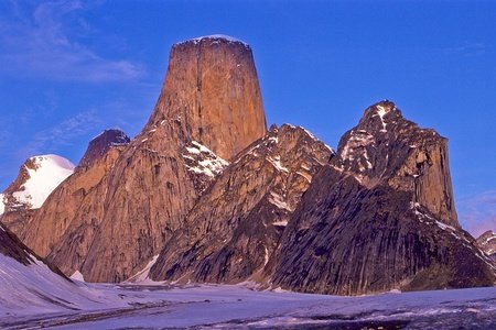
The majority of Nunavut's land, including all of the settlements, is north of the tree line and takes a barren, tundra appearance. This creates spectacular mountain vistas in Auyuittuq National Park (on Baffin Island), including Mount Thor, home to the world's tallest vertical drop at 1250 metres, Mount Odin, Baffin Island's tallest mountain, and Mount Asgard, with its signature, twin-peak rock tower appearance.
In the one forested corner of the territory lies a spot where Nunavut meets with the Northwest Territories, Saskatchewan and Manitoba to form a rare geographical quadripoint. Just off of Kasba Lake, you can find an obelisk marking this anomaly, although unlike its American equivalent you won't find many cars or parking lots here, as it is over 40 kilometres from the nearest (remote) airstrip on the lakeshore.
Most of the population lives on islands, but only a number of Canada's Arctic Island are inhabited. Nunavut's borders extend south to incorporate several islands just off of the coast of Quebec and Ontario, stretching all the way down to the 51° parallel north. Ellesmere Island is the northernmost of the inhabited islands, although Alert (commonly cited as the northernmost settlement in the world), is just a military/weather station, it doesn't have a civilian population.
Alcohol is heavily regulated in Nunavut, sometimes called the "last outpost of Prohibition in Canada" (although there are plenty of other dry areas in the country. Alcohol crime is rampant, and in 2014 the territorial government decided to move towards legalisation. Iqaluit opened a liquor store in 2017, but other communities still differ in terms of restrictions. Legalising alcohol is very controversial, and some residents would rather it be banned completely due to some of the pressing social ills facing the territory.

Nunavut has 25 municipalities, spread out across the landscape. The majority of people live on either Baffin Island (36%) or the mainland.


Some important cities include:
Iqaluit - Once called 'Frobisher Bay', this city has a population of less than 8000, making it the smallest capital city in Canada. The site has been used as an Inuit fishing site for thousands of years, (as referenced in the name Iqaluit, meaning 'place of many fish'), and during WWII the construction of the American Frobisher Bay Air Base increased the non-Inuit population. At one point, Inuit were a minority in the community, but the Canadian government encouraged more Inuit to abandon their nomadic lifestyle and settle permanently in established communities, increasing their numbers. Iqaluit is a very cold city where temperatures regularly hover around -30° in winter, and therefore most of the architecture is designed around practical function, not design (including the lunar-base-esque Nakasuk Elementary School). Igloo-shaped St. Jude's Cathedral challenges this philosophy, however, and has been rebuilt bigger and better following a devastating arson attack. Iqaluit is home to a young population, split evenly between native-English and Inuktitut speakers. Like other communities in Nunavut, snowmobiles are a perfectly acceptable form of transport during the wintertime.
Rankin Inlet - Rankin Inlet is the most populous community on the Nunavut mainland, and was eligible to become the capital of the (then future) territory in a 1995 referendum, although it lost out to Iqaluit. The hamlet, which is located in a subarctic climate, relies on mining to stay afloat, and means to diversify the economy through livestock farming have failed overwhelmingly (the meat had a bad flavour, and tended to end up in the stomachs of lucky polar bears). Rankin Inlet was home to the last of Canada's residential schools, which closed in 1997.
Cambridge Bay - Cambridge Bay is the largest of two hamlets on the massive Victoria Island, and sits on one end of the disputed Northwest Passage. One interesting thing about Cambridge Bay, is that they do not use the syllable writing system here, and the traditional language spoken is Inuinnaqtun. The Canadian High Arctic Research Station was constructed here in 2014 in order to increase Canadian studies on the Arctic.
Pangnirtung - Sometimes called the "Switzerland of the Arctic", due to the mountains which surround the town, Pangnirtung (Pang for short) is called Pangniqtuuq by the locals, although they voted against changing the name in 2005. In 2009, a new harbour was built to increase revenue from the turbot fishing industry, in this town which has also made a name for itself through traditional artwork.
Sanikiluaq - This hamlet can be found on the squiggly Belcher Islands, off the coasts of Ontario and Quebec, and is the southernmost community in Nunavut at 56° north (about the same latitude as Denmark). Here the down (a layer of fine feathers) of eider ducks is collected, useful as padding in pillows or jackets, although the factory had to close from 2005 to 2015 due to a decrease in the duck population.
Grise Fiord - On the contrary, Grise Fiord is the northernmost community in Nunavut, located on Ellesmere Island at 76° north. This hamlet is also the smallest in the territory, with a population of 129, and was created in 1953 through the High Arctic Relocation. Under prime minister Louis St. Laurent, seven or eight families, constituting 92 people, were relocated by the government from Inukjuat (an Inuit community in Northern Quebec), to Grise Fiord and Resolute in the very north of Canada. Inukjuat was seen as an overcrowded area, and there was problems of starvation and dependency on welfare. Moving these Inuit north could remedy this and allow them to continue their traditional lifestyles. However, after being joined by three families from Pond Inlet, (in order to teach them how to survive in their new home), they were dumped in a foreign area, with no knowledge how to survive, and without the buildings they were promised nor the ability to return home, also as promised. This was during the height of the Cold War, and allowed Canada to justify its claims to the high Arctic (since no communities existed north of Baffin Island prior to this time). Grise Fiord is the northernmost community in Canada, and one of the coldest in the world, and due to its remote location on rocky terrain, the economy is largely subsistence-based. Romanian citizen, Florin Fodor attempted to illegally immigrate to Canada via Grise Fiord in 2006, via boating from Sisimiut, Greenland, the first person foolish (or crazy) enough to try such a route

And that's all for the territories! I cannot believe this series is over, it has been quite the ride indeed :)
Thanks to each and every one of you who took the time to click on these blogs/read them. I hope you had a great (mini) Canadian holiday!
Canada's territories are some of the most unique and obscure parts of the country, thanks to their remoteness. In a country that considers cities such as Grande Prairie and Prince George to be 'north', it is interesting to think about these places, still 500km north of those cities.
I propose a Sourtoe Cocktail cheers, to the conclusion to this series!
Now I’m bored to write something lol
Maybe the Indigenous influence is greater because of how far north they are - Europeans didn't change their customs and culture until much later overall, and many groups would have lived very traditional lifestyles until the 20th Century, within living memory.
I simply cannot imagine living in one of those remote, fly-in communities in Nunavut, where you could grow up never seeing a tree in person.
The northern states really interest me. The nature of them is outstanding! This thing of “there is only one city”, is like that the others are not incorporated regions? Or like towns? In Brazil we don’t have this differentiation of city vs. town. We usually say city for everything, and also forget about the difference of municipality and city (biggest city usually can mean population, and biggest municipality usually can mean area). And there can be two cities in a municipality (the city itself — district-seat —, and a minor district) lol.
The only problems with your blogs, is the fact they aren’t infinite. Because I would read them multiple times!
It's a sort of legal difference, affecting how it is governed/how many councillors it can have. All dots on the map represent incoroporated locales, however. We (Anglo-Canada) make more of a distinction than Quebec, where many settlements are grouped together as villes but less of a distinction than Britain, I believe.
Innuktitut Syllabics look quite abstract, although when you read the article on Wikipedia, about the sound each character makes, it starts to make more sense. The way it works is really quite novel, I've never seen a writing system where you can rotate the characters to change the sound they make!
And oh, but how do that work? Like, Yellowknife (e.g.) is a city. And “random” is a town? A village?
They have different organisations, in order to best serve their population. here is a list of all the kinds of municipalities in Canada. It doesn't always related to population, either, and just because something is a town/city/etc. doesn't mean we will care to specify which it is. For example, in Alberta Fort McMurray is technically a hamlet, although the average person wouldn't know or care, they would call it a 'city'. So mainly a government distinction with some correlation to size.
It's also a shame that not many people know about the Canadian four corners as opposed to its American counterpart. Although, I suppose it makes sense, given the American quadripoint is much more accessible than Canada's.
As usual, amazing blog! Ethaboo's going to have a field day with this series lol. These Canadian blogs are definitely among my favorite of all time!
I guess the Canadian quadripoint is also quite new, thanks to Nunavut being such a new territory. In fact, the monument on the four corners site is from 1962, so the monument itself only acknowledges Saskatchewan, Manitoba, Northwest Territories.
Many thanks for reading the blogs, I'm glad you enjoyed them :D
Unfortunately, I have to remain with the boring old "American". Which technically isn't even right, since North America and South America together is America. I suppose it's better than being called a United Statan or a United Statesian, though!
I just found a Wikipedia page for all the demonyms for people from the US. I'm really glad we use 'American' in English and not 'Usonian', or 'Uesican'!
I actually can't believe United Statesian is an actual demonym. Along with United Stater. That doesn't really make sense, given -er is generally associated with nouns that have a root in verbs? I'm not "United Stating", but I live in the United States. I suppose it has the same connotations as "Berliner", but, like Northwest Territorian, it just doesn't sit right... English is weird.
Also, this is completely different from this current topic, but, as you are a Canadian, how is the War of 1812 taught in school, if at all? In America, we don't really talk about it in education, but it appears that a lot of people think we won (due to the Battle of New Orleans). To be honest, I don't think getting one's capital burnt down is characteristic of winning. I would call it having been a draw, given that not much happened as a result of it (even though we were extremely bad at invading Canada). It could be argued that we lost, though, given that a lot of our military campaigns were failures, and a lot of the war was spent defending. Any thoughts?
I think a lot of us have this idea of sort of ordinary Canadian farmers going up against this much larger power and winning. In reality, the Canadian farmers were losing pretty badly, and the tides only equalised when Britain sent troops over following Napoleon's defeat in Russia. It seems like it was all a waste, even if both sides claim we won to this day, since we returned to the status quo after all. The main effect of the war was probably scaring the Canadian authorities from embracing democracy for another 30 years, I really do think they overstate how important it was compared to other wars in our history!
To be honest, I think the winning of the war is a matter of national pride; America doesn't want to admit it was rebuffed by Canada and Britain so soon after it got its independence, and Canada, like you mentioned, has the idea of ordinary Canadians being able to overcome their adversary (but later to be ally) to the south.
I guess I shouldn't be surprised that you never heard of the Battle of New Orleans, given it was inconsequential to the war as a whole, and was technically not even part of the war, since the peace treaty was signed before the battle was fought. The only thing much significant about it is how much we Americans make it to be ourselves, as well as the fact our future President, Andrew Jackson, was a general in the Battle (The victory at New Orleans gave him a major popularity boost in the election).
Included the last one because I feel like a lot of Americans, and Westerners for that matter, think Japan was so intimidated by the city-destroying bombs that they surrendered. While that was true, it wasn't the only reason. The Soviet Union invading from the West was also a significant threat for Japan, due to the massive military that would overwhelm their empire now that it wasn't being held down by Germany. They knew that, had they not surrendered, Japan would have been invaded (which would be very bloody, but quite possible), by either the US or USSR, and would have had their culture crushed and repressed, similar to how they treated Korea.
Canada hasn't been too involved in warfare, so we don't have many wars to look back on with pride. I'd say that WWI and 1812 get the most focus, arguably (Canada played a pretty big role in WWI and it gave the country a sense of nationalism). We don't talk a whole lot about the Rebellions of 1837, even though this led to democracy in Canada in 1848. In school we never talked about the impacts of the American Revolution and the US Civil War (which had a big impact on the settling of English-speakers in Canada and Canadian Confederation, respectively).
Also, I've seen lots of claims that Canada has never lost a war before in America. After looking that up, I was surprised to find that it actually was pretty much the case. After 1867, which is arguably when Canada first formed, the only war she lost that she was involved in some way in was the Russian Civil War, when she was supporting the White Army. And even then, it wasn't a major intervention, given Canada only lost 14 soldiers (although that shouldn't be downplayed). There was also another one, the War in Afghanistan, which was also a defeat. So Canada technically has lost a war before. However, she has not lost a war before when she was fighting on her own, so that's a plus, I suppose.
This is still a serious dispute that both countries are trying to solve, and if oil or other resources were found on Hans Island I could see it causing a problem. As the Arctic Ocean becomes warmer, I can only imagine what kind of disputes will arise in future over resource control but also shipping routes.
I should add that most Canadians don't think too much about it, we certainly don't hate Denmark or anything! I may be biased here, since I have Danish relatives :D